Interpretations of the National Soil Map of England and Wales
NATMAP Carbon
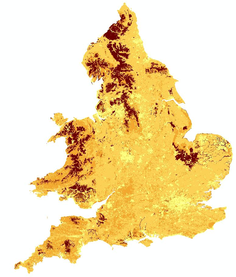
Soil Organic Carbon Map
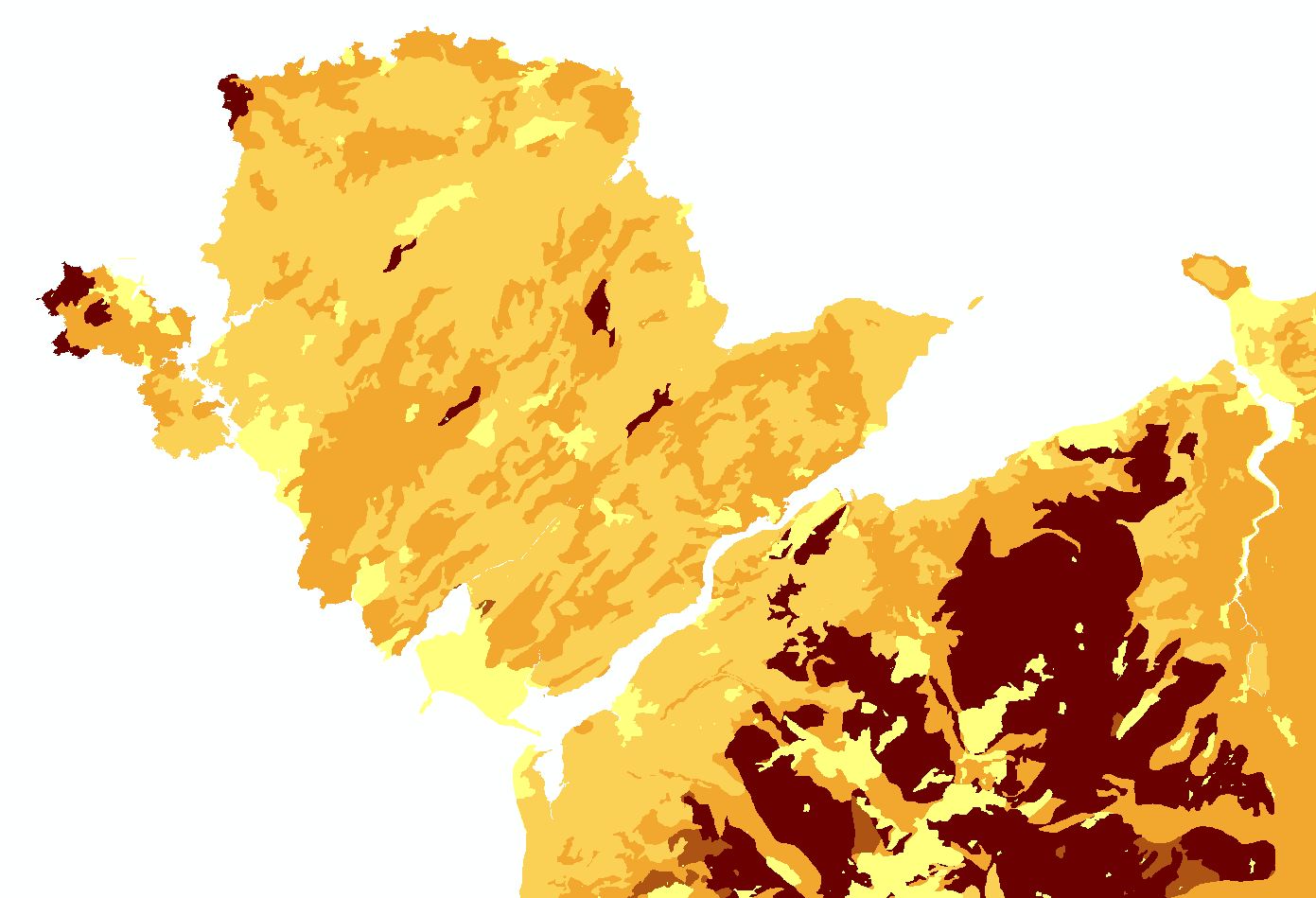
NATMAPcarbon is a new product derived from the National Soil Map. It provides users with a summary of the stock of carbon in the soils across England and Wales at three layer depths 0-30 cm, 30-100 cm and 100-150 cm.
Key Facts and Statistics about NATMAPcarbon
- Simplified rendition of the national soil map;
- Average Organic Carbon percentage in soils for 3 soil layers
- Organic carbon stock per unit area for 3 soil layers
Who and what is this useful for?
NATMAPcarbon is useful for anyone wanting information on the expected carbon stock in the soils of England and Wales. This data is used as part of the Greenhouse Gas Inventory
How was this map derived?
For each soil series represented on the National Soil Map the organic carbon data held in the HORIZONfundamentals dataset was averaged across each of the 3 layers, the total stock in each horizon was calculated from the organic carbon and bulk density data taken from HORIZONhydraulics.
The organic carbon data varies under different landuses and so the values for each soil series under arable, permanent grass and other landuses (mostly woodland or rough grazing) were seperated.
To interpret this on a soil association basis the mean carbon values for each component series was calculated, weighted by the proportion of each series in the soil association under the three landuses.
The National Soil Map was then intersected with a landuse map dissolved from the Corine land cover 2000 map to just the 3 landuse classes required. Each polygon on the map was then linked to the carbon data with the relevant map unit and landuse combination.
How much does this product cost?
- £250 per 1,000 km2.
- Significant discounts apply for larger areas.
For detailed pricing information, use our Quotation Advisor utility.
NATMAP Carbon data and description
The table below describes the various properties within this data product. Each polygon contains the information outlined below.
| Property | Example from data | Description |
|---|---|---|
| AV_OC_30 | 2.26 | Average Organic Carbon between 0 and 30cm depth (%) |
| MN_OC_30 | 2.12 | Minimum Organic Carbon between 0 and 30cm depth (%) |
| MX_OC_30 | 2.43 | Maximum Organic Carbon between 0 and 30cm depth (%) |
| AV_OC_100 | 0.86 | Average Organic Carbon between 30 and 100cm depth (%) |
| MN_OC_100 | 0.81 | Minimum Organic Carbon between 30 and 100cm depth (%) |
| MX_OC_100 | 0.93 | Maximum Organic Carbon between 30 and 100cm depth (%) |
| AV_OC_150 | 0.2 | Average Organic Carbon between 100 and 150cm depth (%) |
| MN_OC_150 | 0.16 | Minimum Organic Carbon between 100 and 150cm depth (%) |
| MX_OC_150 | 0.24 | Maximum Organic Carbon between 100 and 150cm depth (%) |
| AV_STK_30 | 8.29 | Average Stock of Organic Carbon between 0 and 30cm depth (Kg/m2) |
| MN_STK_30 | 7.93 | Minimum Stock of Organic Carbon between 0 and 30cm depth (Kg/m2) |
| MX_STK_30 | 8.75 | Maximum Stock of Organic Carbon between 0 and 30cm depth (Kg/m2) |
| AV_STK_100 | 8.17 | Average Stock of Organic Carbon between 30 and 100cm depth (Kg/m2) |
| MN_STK_100 | 7.82 | Minimum Stock of Organic Carbon between 30 and 100cm depth (Kg/m2) |
| MX_STK_100 | 8.6 | Maximum Stock of Organic Carbon between 30 and 100cm depth (Kg/m2) |
| AV_STK_150 | 1.41 | Average Stock of Organic Carbon between 100 and 150cm depth (Kg/m2) |
| MN_STK_150 | 1.07 | Minimum Stock of Organic Carbon between 100 and 150cm depth (Kg/m2) |
| MX_STK_150 | 1.68 | Maximum Stock of Organic Carbon between 100 and 150cm depth (Kg/m2) |
| AREAkm | 144.525 | Area of the polygon in km2 useful for calculating the total stock for the polygon by multiplying with the stock per unit area |
| SHAPE | 2 | Feature ID code which links with the spatial description of the data within a geodatabase |
