
Soil Associations
0343h ANDOVER 1
Soil and site characteristics
Shallow well drained calcareous silty soils over chalk on slopes and crests. Deep calcareous and non-calcareous fine silty soils in valley bottoms. Striped soil patterns locally.
Geology
Chalk
Cropping and Land Use
Winter cereals and short term grassland with dairying and stock rearing; cereals, sugar beet and potatoes in Lincolnshire and Yorkshire; some woodland.
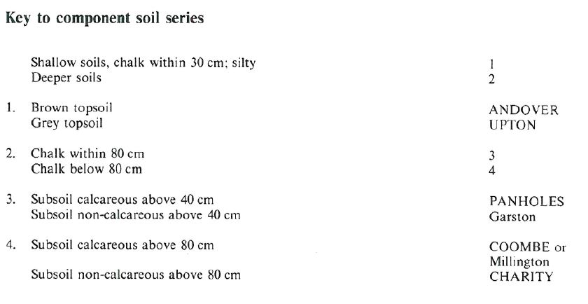
Component soil series
| Subgroup | Series name | Percentage | WRB 2006 link |
|---|---|---|---|
| 3.43 | ANDOVER | 55% | Calcaric Leptosols |
| 5.11 | PANHOLES | 15% | Calcaric Endoleptic Cambisols |
| 5.11 | COOMBE | 10% | Calcaric Cambisols |
| 3.42 | UPTON | 10% | Rendzic Leptosols |
| 5.71 | CHARITY | 10% | Chromic Luvisols |
Covers 3042 km2 in England and Wales
Soilscapes Classification
| 3 |
Shallow lime-rich soils over chalk or limestone |
0343h ANDOVER 1
Detailed Description
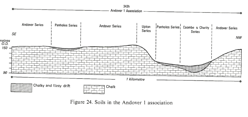
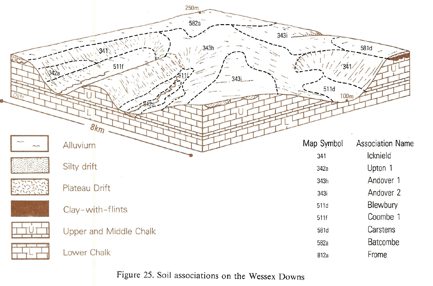
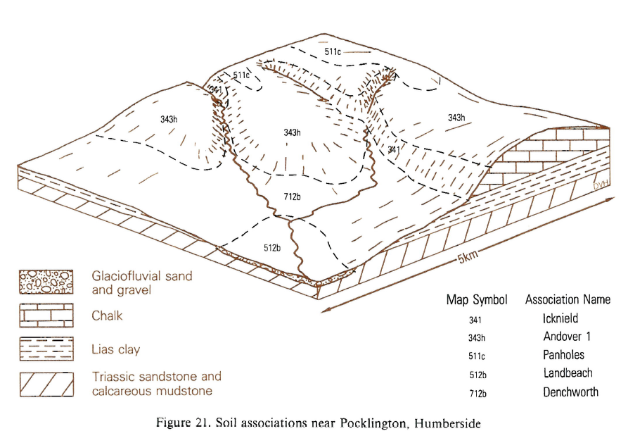
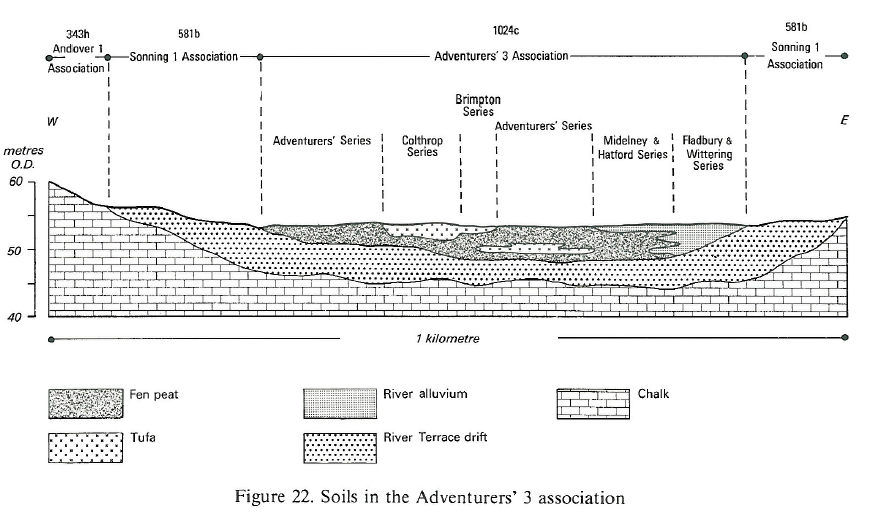
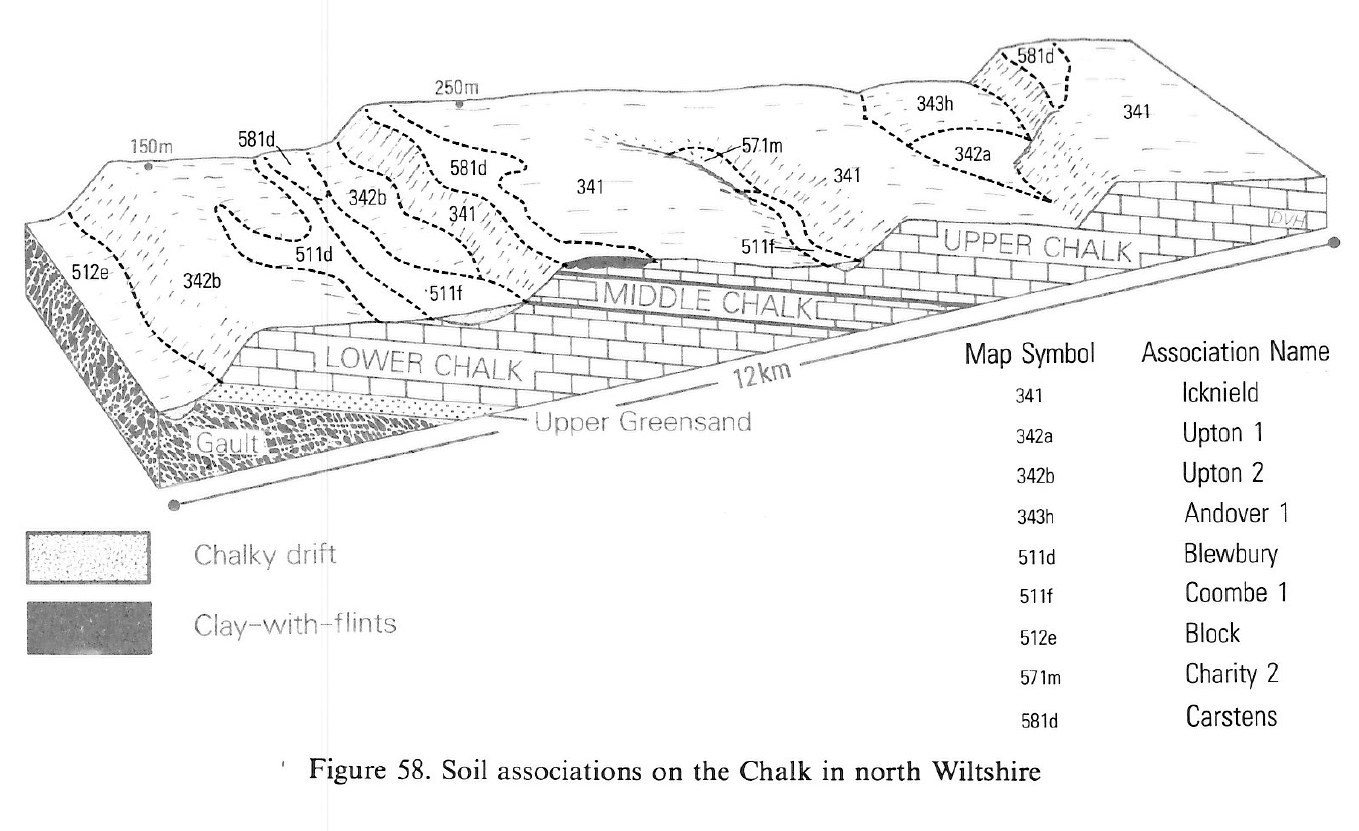
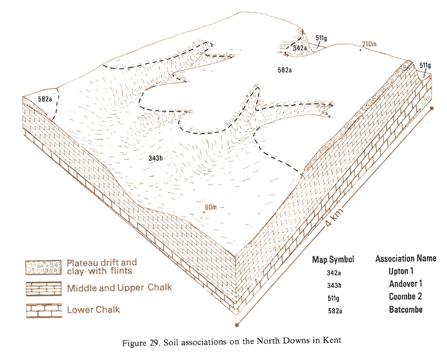
This association is found on undulating chalkland dissected by narrow dry valleys in the Wolds of Yorkshire and Lincolnshire, and on the Downs of southern England. The most common soils belong to Andover series, variably flinty and chalky fine silty brown rendzinas, over chalk. They are associated with Panholes and Coombe series, fine silty typical calcareous brown earths in rubbly chalk and chalky drift respectively on footslopes and valley floors. Upton soils, extremely calcareous loamy grey rendzinas, are restricted to the steeper slopes where cultivation and subsequent erosion have removed much of the original topsoil and incorporated some chalk into the plough layer. Fine silty typical argillic brown earths (Charity series) are developed locally in non-calcareous flinty drift on valley floors. In places striped patterns, shown by differences in soil colour or by differences in crop ripening, reflect the variable soil thickness over chalk.
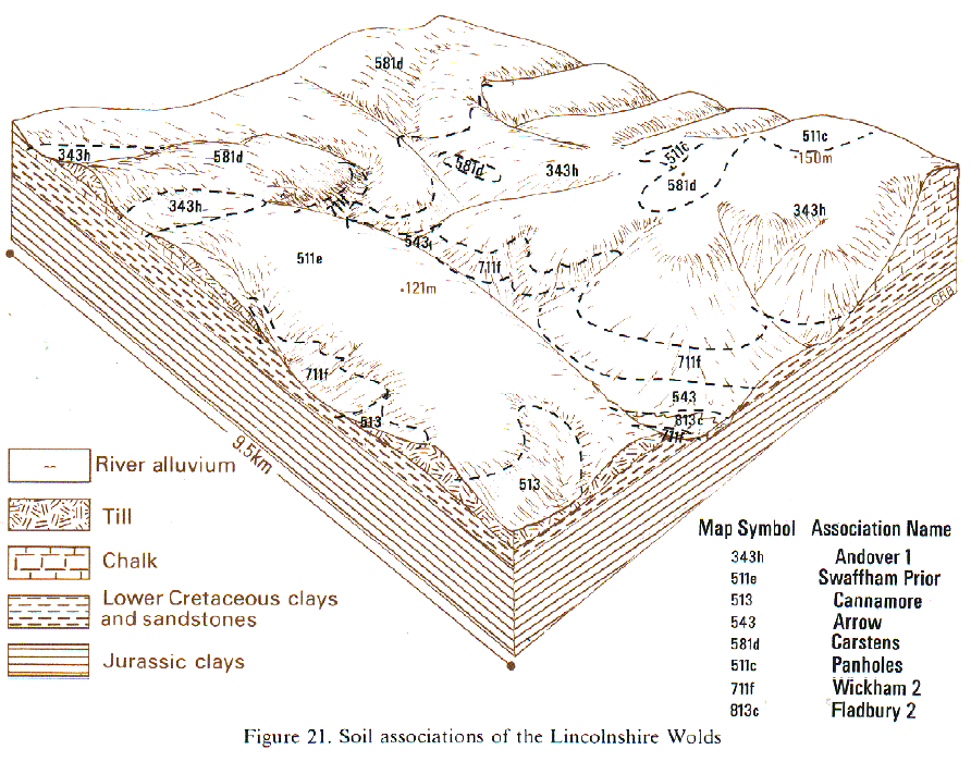
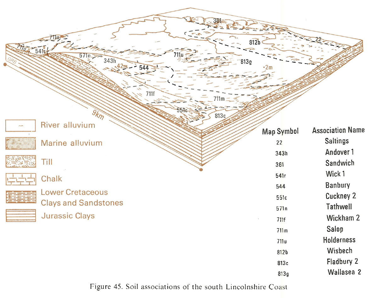
The association occurs on the chalk escarpment in Lincolnshire, on the upper part of the west-facing scarp slope and on the gently sloping dipslope. The proportion of Panholes series is largest near patches of very chalky till on higher ground. The dipslope is dissected by a complex network of steep-sided dry valleys floored mainly with Coombe series with Upton soils on their upper slopes, but locally in the east there are small areas of seasonally waterlogged Gayton soils where Head deposits overlie Devensian till. In Eastern England, Charity series is absent. Distinctive reddish Andover soils occur locally as narrow strips on valley sides on Lower Cretaceous Red Chalk. Near Burgh on Bain similar reddish soils cover appreciable areas on level ground.
In Dorset Andover soils are found on moderate and gentle slopes and though they may contain many chalk stones, the brown silty clay loam matrix is rarely highly calcareous. Flintiness varies greatly, often within a field, but the most flinty soils are generally on ridge tops. Within the association, very steep slopes or scarps are often under semi-natural grassland, scrub or woodland, and carry humose Icknield soils. Deeper Coombe and Charity soils are most extensive in valley bottoms where calcareous chalky drift and non-calcareous flinty silty drift is found. There are inextensive inclusions of Garston Winchester and Carstens series on some ridge crests. In Wiltshire, on Salisbury Plain, Charity soils are uncommon, but Icknield soils occur sporadically around the military ranges and Upton soils are common on convex brows, giving a more complex pattern of shallow soils than elsewhere. The widespread distribution of ancient field systems and lynchets in Dorset and Wiltshire gives a complex pattern of soil depth and stoniness.
On the gently undulating dipslope of the high Wolds, Andover soils are extensive wherever surface drift is thin but Panholes soils are more common on lower and flatter sites. Although Charity soils are rare the similar but shallow Garston series occurs on higher ground wherever there is non-calcareous drift. Striped patterns periodically appear in several localities, especially around Foxholes.
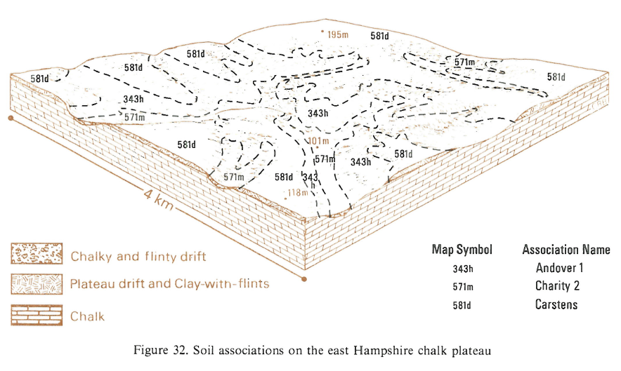
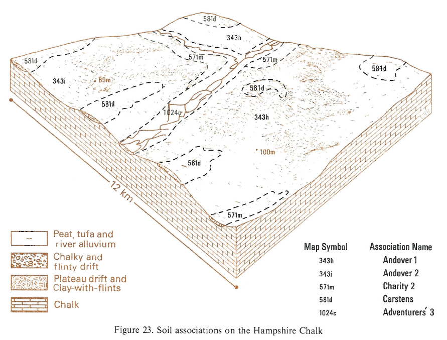
Large areas of land on the Hampshire Downs, Berkshire Downs and the South Downs dipslope are composed mainly of Andover soils with Panholes soils occurring on flatter sites or lower valley sides where drift has accumulated. Upton soils occur on valley sides and scarp slopes. Charity soils are developed either in decalcified drift in the larger valleys or in drift derived in part from the Clay-with-flints or Plateau Drift upslope. Millington and Notley soils are common in calcareous and non-calcareous colluvium on footslopes, in small dry valleys behind hedgebanks and on lynchets. In east Hampshire, on the Chiltern Hills and on the North Downs, where there is thick Plateau Drift or Clay-with-flints, the association is found only in dry valleys and here Andover soils occur on steep slopes with associated Upton and lcknield soils; Charity soils are dominant on valley floors in these districts and there are small inclusions of Winchester, Carstens and Garston soils on narrow ridges.
Soil Water Regime
All the soils are well drained (Wetness Class I) and rest on permeable chalk. Winter rain is readily absorbed and there is little run-off. The droughtiness of shallow chalk soils is difficult to estimate since crop performance suggests that plants extract more water than the amount available in the soil. Chalk itself holds water readily available to plants amounting to 15 to 35 per cent of its volume (Bunting and Elston 1966, Jarvis 1973) and there is evidence that, where the chalk subsoil is shattered, roots penetrate deeply and can extract water from such material. Shattered chalk is probably widespread though its extent and thickness are difficult to predict. Eroded soils (Upton series) and those over the harder chalk strata, generally have thinner layers of broken material and are likely to be more droughty. The Andover, Coombe and Panholes series are non-droughty soils in the Wolds for most crops although slightly droughty for grass. Shallow Upton soils are slightly droughty for most arable crops and moderately droughty for grass. Andover soils are permeable and well structured, making them easy to work even after rain. They dry rapidly in spring, are cultivable in all seasons and are well suited to minimum cultivation. Under grass, there is little likelihood of poaching and the outwintering of cattle is possible in sheltered fields. Although these soils have moderate levels of organic matter they are naturally deficient in available phosphorus, potassium and magnesium.
Cropping and Land Use
Shallow soils recently ploughed or reclaimed from permanent grassland or woodland are particularly deficient in potassium, and there is a risk of magnesium deficiency in barley. Most soils are neutral or alkaline in reaction. In cattle, magnesium, copper and cobalt deficiencies can occur. Much of the land is under continuous cereals or cereal and ley rotations; steeper slopes have permanent grass. Barley is the most common cereal crop, much of it being sent for malting. Good crops of sugar beet can be grown but potatoes are often preferred. Brussels sprouts and vining peas are grown near Grimsby. Sheep and beef cattle are grazed on steeper slopes although sheep are also folded on kale and turnips sown mainly for game cover.
Remnants of semi-natural grassland are restricted to sites on the Imber, Larkhill, Tidworth and Porton military training areas where herb-poor grassland occurs in various stages of reversion from arable use. Where ungrazed the vegetation is often rank and Arrhenatherum elatius-Festuca rubra-Helictotrichon pubescens grassland is dominant with few herbs present. Other coarse grasses, notably Dactylis glomerata, Zerna erecta and Agrostis stolonifera are also frequent. The rare Erucastrum gallicum is abundant along tracks through the Tidworth and Larkhill ranges. A small grassland area on Prescombe Down, Wiltshire contains herb-rich Carex humilis-Festuca ovina grassland.
In West Sussex and south Hampshire grass benefits from a flush of growth in the autumn. Other break crops include herbage seed, either undersown or re-seeded in autumn, harvested for one or two years and then grazed or used for silage or returned to cereals, oilseed rape, peas or beans.
In the South East Beech has been widely planted and grows well particularly on Andover soils on north and north-east facing slopes. Growth is slower however on Upton soils. Ash and sycamore are suited to the deeper calcareous Coombe and Panholes soils as is Western red cedar, although its shallow root system causes instability. Chlorosis restricts commercial plantings of Scots pine, larches and Douglas fir but Corsican pine which is lime-tolerant grows successfully in places and is also a suitable nurse crop to beech. Attack by the fungus Fames annosus leading to root death and butt rot is a serious risk for conifers. There are four National Nature Reserves on this association and seven key sites illustrating a range of chalkland habitats. Of these, Castle Hill, Sussex has typical herb-rich Festuca ovina-F. rubra grassland. Chalk heathland, with both acidophilous and calcicolous species, occurs notably at Martin Down and Lullington Heath, where ling (Calluna vulgaris), bell-heather (Erica cinerea) and Festuca ovina-F. rubra grassland occur in close association on Andover soils with acid surface horizons. Yew woodland is extensive at Kingley Vale along with herb-rich grassland and some chalk heath, and yew (Taxus baccata) is associated with juniper (Juniperus communis) and mixed scrub at Stockbridge Down, Hampshire. A varied complex of scrub with an old stand of juniper is found at Rushmoor Down, Hampshire. Aston Upthorpe Down in Oxfordshire also contains extensive juniper along with Festuca ovina grassland and mixed scrub.
Ash and field maple (Acer campestre) are typical of the semi-natural woodlands usually with coppiced hazel, although pedunculate oak and beech have been widely planted. Wych elm occurs on footslopes and with beech and ash on steeper slopes. Common calcicolous shrub species include spindle-tree (Euonymus europaeus), guelder rose (Viburnum opulus), wayfaring tree (V. lantana), dogwood (Cornus sanguinea) and privet (Ligustrum vulgare). Dog's mercury (Mercurialis perennis) often dominates the herb layer and can conceal moschatel (Adoxa moschatellina), goldilocks (Ranunculus auricomus) and pignut (Conopodium majus).
0343h ANDOVER 1
Distribution Map
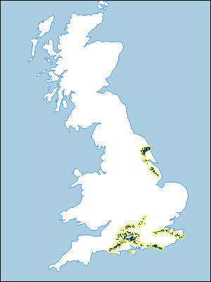 |
Note that the yellow shading represents a buffer to highlight the location of very small areas of the association.
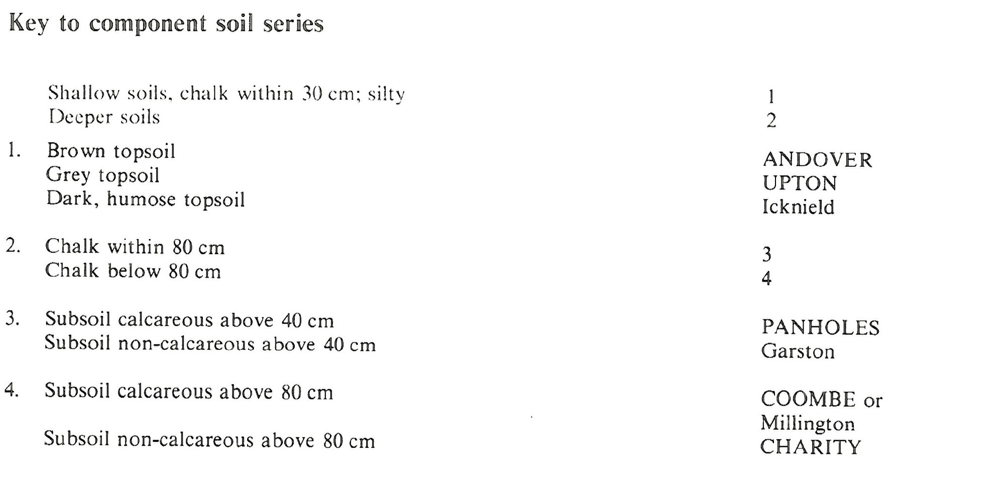
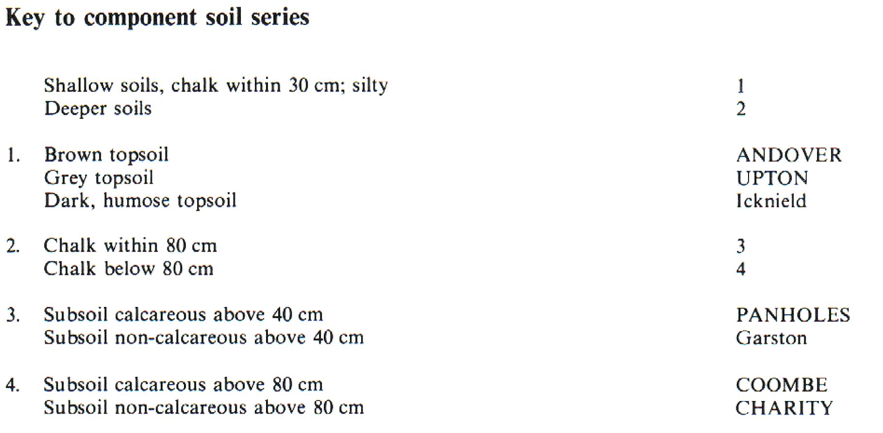
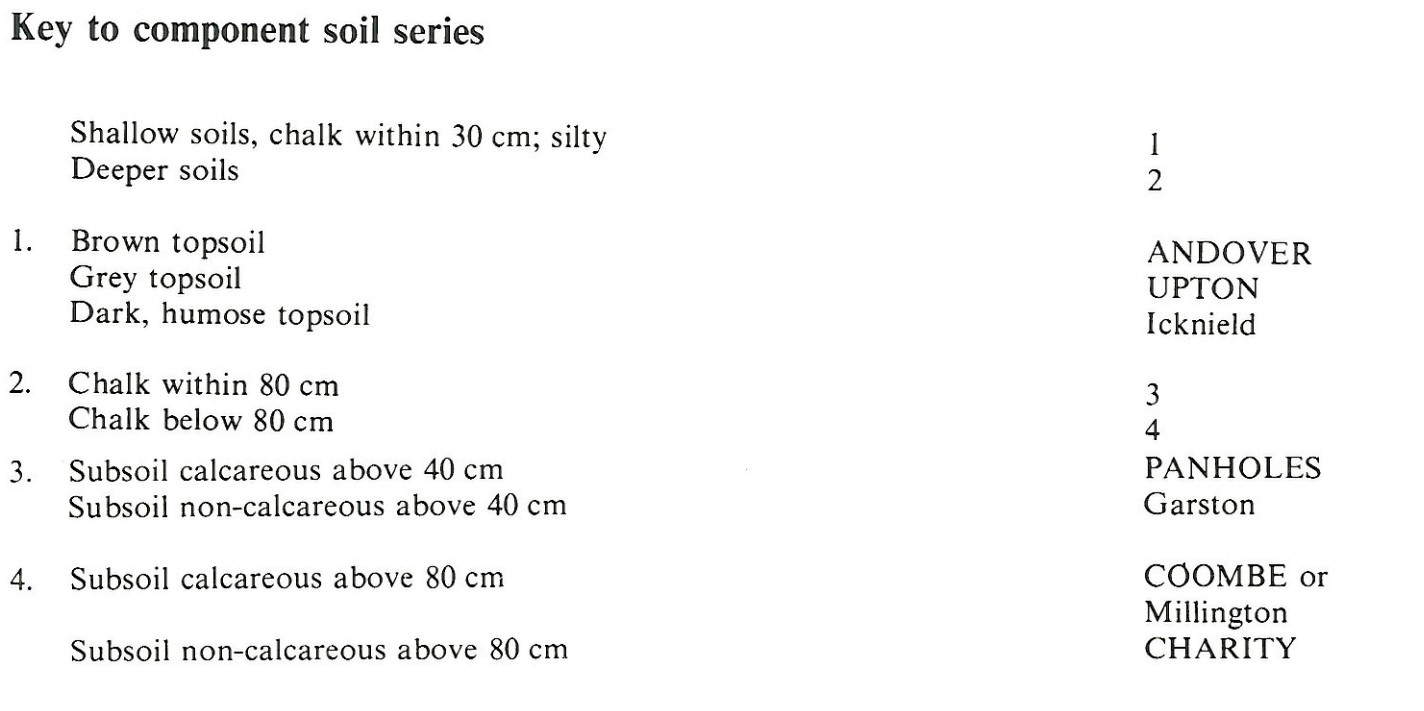
Keys to component soil series
South Eastern Region
 |
Eastern Region
 |
South Western Region
 |
Northern Region
 |
Typical Landscapes
South Eastern Region
 |
South Western Region
 |
South Western Region
 |
South Western Region
 |
Eastern Region
 |
Eastern Region
 |
Northern Region
 |
South Eastern Region
 |
South Western Region
 |
South Eastern Region
 |
South Eastern Region
 |
South Eastern Region
 |
All information Copyright, Cranfield University © 2024
Citation: To use information from this web resource in your work, please cite this as follows:
Cranfield University 2024. The Soils Guide. Available: www.landis.org.uk. Cranfield University, UK. Last accessed 20/04/2024
