
Soil Associations
0541h NEATH
Soil and site characteristics
Well drained fine loamy soils often over rock. Small patches of similar soils with slowly permeable subsoils and slight seasonal waterlogging.
Geology
Carboniferous sandstone and shale
Cropping and Land Use
Dairying and some cereals and stock rearing; some early potatoes in Dyfed.
Component soil series
| Subgroup | Series name | Percentage | WRB 2006 link |
|---|---|---|---|
| 5.41 | NEATH | 31% | Eutric Endoleptic Cambisols |
| 5.42 | NERCWYS | 29% | Eutric Stagnic Cambisols |
| 5.42 | CHERUBEER | 10% | Ruptic Endoclayic Stagnic Cambisols |
Covers 1607 km2 in England and Wales
Soilscapes Classification
| 6 |
Freely draining slightly acid loamy soils |
0541h NEATH
Detailed Description
Fine loamy brown soils over sandstone dominate the Neath association. It is extensive in South West England and Wales and is scattered throughout the Midlands. The Neath soils, typical brown earths, are permeable and well drained, with brown, clay loam upper horizons containing fine sandstone and siltstone fragments which increase in number downwards, as the soils pass into rubbly Head or fractured bedrock. The ancillary soils vary from district to district.
In the Midlands, the association covers about 70 km² and is confined mainly to Millstone Grit in Shropshire west of Oswestry, the Derwent valley in Derbyshire and the Churnet valley in Staffordshire. It is found on 3 to 20 degree slopes at elevations of 100 to 400 m O.D. In Derbyshire where it occurs on interbedded Carboniferous shale, sandstone and gritstone, Neath soils cover about half the land and the main subsidiary soil is Denbigh series. Nercwys, Rivington, and Brickfield soils) are present in most delineations in Derbyshire but are relatively inextensive components. In Shropshire, the association includes many East Keswick and some Rivington soils, with Brickfield series found in wetter places. In all districts brown podzolic soils such as Withnell and Manod series are found on steeper, unimproved sites.
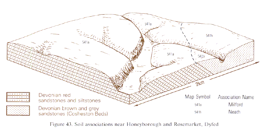
In south Wales and Clwyd, the Neath association is mapped principally on the Coal Measures, where it occupies gentle or moderate slopes below 170 m O.D. Although the well drained Neath series predominates, some wetter soils are present in patches of drift. In Clwyd these include Brickfield and Cegin series, but in most of south Wales Nercwys series is the principal ancillary soil. On the south Dyfed coalfield there are more wet soils in the association. Well drained brown earths, brown podzolic soils and locally rankers are also present. They differ from Neath series in texture, parent material or soil depth. Shales are interbedded with the standstones in south Dyfed and carry Denbigh, Barton and Powys series. In Clwyd deeper brown soils in drift, with rocky layers below 80 cm depth, notably the fine loamy East Keswick series, form an important element but shaly soils are largely absent. Typical brown podzolic soils are included on steep land. They are represented in Glamorgan mainly by the coarse loamy Withnell series , but in Clwyd also by the fine loamy Manod series. Small patches of Neath association are mapped over older rocks in south-west Dyfed near St David's, around St Ann's Head and near Pembroke. Here some coarse loamy brown-earths of the Rivington series are included, while wetter associate soils are rare.
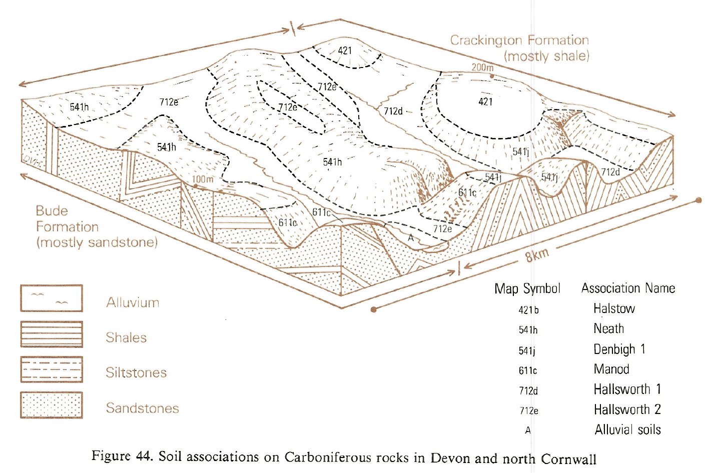
On the rolling hills over the Culm Measures of Devon and north Cornwall, where the association is most widespread, wetter soils of the Nercwys series are commonplace. These stagnogleyic brown earths, formerly mapped as Holsworthy series , are co-dominant with Neath soils, and are differentiated by mottled, less permeable, clay loam subsoils. Elsewhere, in parts of Wales, the southern Pennines, west Gloucestershire and the Bristol coalfield, wetter soils are less common.
In central Devon and north Cornwall Neath association is a complex mixture of soils. Soil texture and degree of gleying change rapidly over short distances, and a widespread observation among farmers is that no field lacks a wet spot. The association, mapped mainly over the Bude Formation with its thick sandstones, is also found on the shaly Crackington Formation west of Okehampton. Here, the clayey Halstow association, widespread over shale on ridge crests near Exeter, gives way to more mixed, loamy soils of this association, with Neath series being partly displaced by Denbigh series. This change probably reflects an increase in the proportion of sandstones and low grade metamorphic alteration of the shales which accordingly weather less easily to clay. In Devon and Cornwall the association interfingers closely with Hallsworth 2 association of surface-water gley soils. Boundaries, often abrupt, are oriented from east to west along the geological strike and south-east to north-west parallel to faults in the Culm Measures. The associations occupy broadly convex and concave landscape facets respectively. On steeper land the Neath association passes into the Manod association. Reddish soils occur sporadically in a wide fringe along the boundary to the Permo-Triassic red rocks.In the Bristol coalfield Neath soils, mapped originally as Swindon Bank, are on upper slopes and crests of ridges with Nercwys on shales and mudstones on the lower ground. In the Forest of Dean the association occurs on the Drybrook sandstone.
Soil Water Regime
Neath, Denbigh, Withnell and Manod soils are porous and overlie permeable substrata, so are rarely wet (Wetness Class I). Nercwys soils are seasonally waterlogged (Wetness Class III and IV). The soils readily absorb rainwater except on steep slopes and where there is a higher proportion of wetter land. Hydrological studies on surface-water gleys in similar parent material in Devon (Harrod 1981) indicate that the underlying rubbly Head is permeable. In average years moisture reserves in the main soils are adequate. Even in the driest districts the soils are only slightly droughty for grass and non-droughty for other crops.
Cropping and Land Use
Grassland farming dominates with permanent pastures usually more numerous than leys. With sufficient moisture reserves and favourable drainage, Neath series is well suited to grassland use, having little risk of damage by poaching or traffic. However local inclusions of wetter soils in flush sites limit use. Grassland improvement by cultivation and reseeding is commonly restricted by steep slopes so much of the steepest land is wooded. Unmanaged oak woods occupy some steep slopes, but coniferous forestry is inextensive, only Douglas fir (Pseudotsuga menziesii) plantations at Penllergaer near Swansea, being of any size.
In Devon and Cornwall closely spaced soil variation often makes crops patchy, particularly through wet spots. Due to sufficient moisture reserves and favourable drainage, Neath series is well-suited to grassland without much risk of damage by poaching or traffic, but where intermixed with wetter soils damage to pastures is more likely. Similarly in dry districts Neath series is workable for long periods even in wet autumns, but not in spring. However admixture with wetter soils, notably Nercwys series, curtails work time. Moderately high amounts of silt and fine sand mean that bare soil caps and slakes under rain impact.
0541h NEATH
Distribution Map
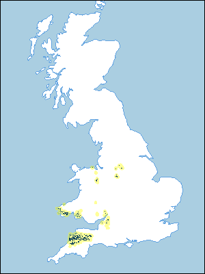 |
Note that the yellow shading represents a buffer to highlight the location of very small areas of the association.
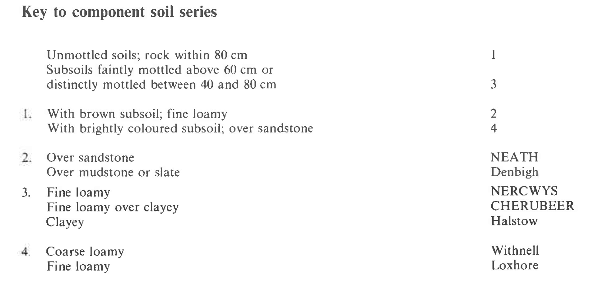
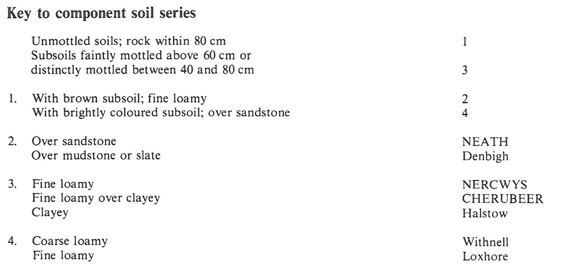
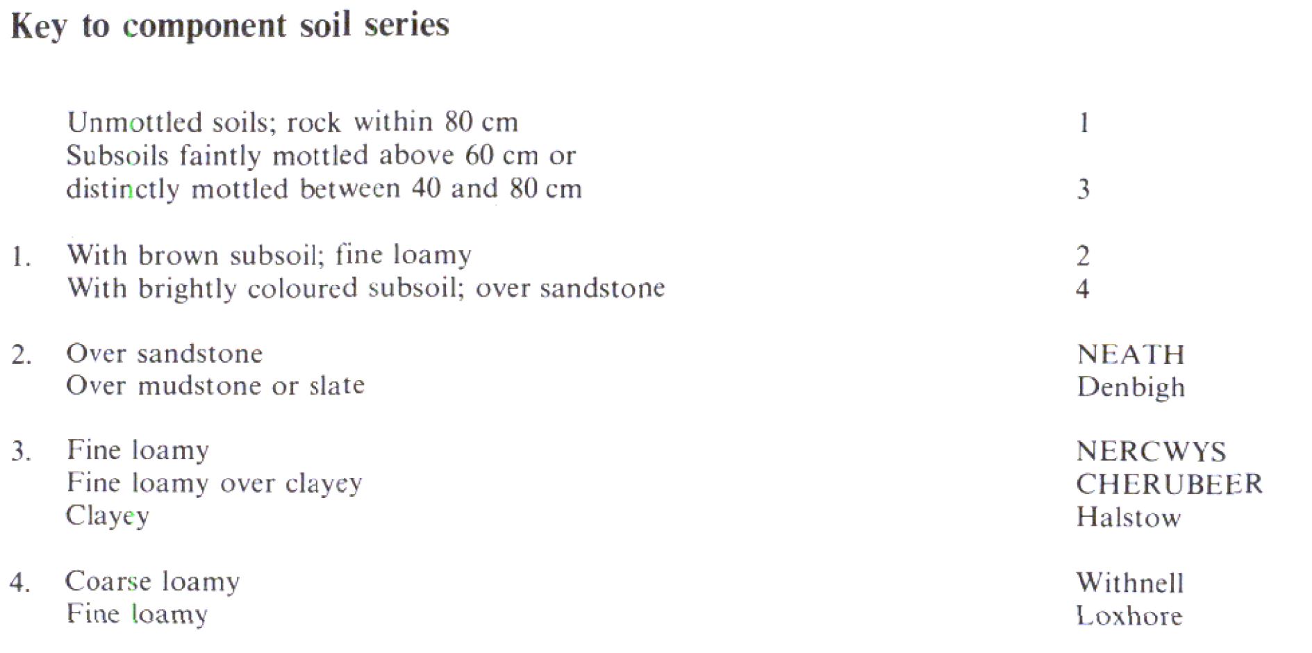
Keys to component soil series
Midlands
 |
South Western Region
 |
Wales
 |
Typical Landscapes
South Western Region
 |
Wales
 |
All information Copyright, Cranfield University © 2024
Citation: To use information from this web resource in your work, please cite this as follows:
Cranfield University 2024. The Soils Guide. Available: www.landis.org.uk. Cranfield University, UK. Last accessed 23/04/2024
