Soil Associations
0541u ELLERBECK
Soil and site characteristics
Very stony well drained loamy soils locally on hummocky ground. Some similar but less stony soils.
Geology
Glaciofluvial drift
Cropping and Land Use
Stock rearing on permanent grassland in moist lowlands; some cereals, sugar beet and potatoes in drier lowlands.
Component soil series
| Subgroup | Series name | Percentage | WRB 2006 link |
|---|---|---|---|
| 5.41 | ELLERBECK | 40% | Dystric Episkeletic Cambisols |
| 5.41 | HALL | 30% | Eutric Endoskeletic Cambisols |
| 6.11 | BASCHURCH | 20% | Episkeletic Entic Podzols |
Covers 267 km2 in England and Wales
Soilscapes Classification
| 6 |
Freely draining slightly acid loamy soils |
0541u ELLERBECK
Detailed Description
This association of dominantly free draining soils is developed on very stony glaciofluvial or river terrace drift in Northern England, the Midlands and Wales. It contains loamy-gravelly Ellerbeck and Baschurch soils and also the less stony, coarse loamy Hall series, which overlies gravel at between 40 and 80 cm depth. The terrain is undulating or hummocky on lower valley sides or bottoms, or almost level on outwash fans. The Ellerbeck series has a brown, slightly or moderately stony surface horizon changing abruptly at plough depth to a dull, very stony sandy loam or clay loam which overlies gravel containing little fine earth. The Baschurch series is similar but the subsoil is enriched with translocated iron and aluminium. The porous nature of all these soils allows roots to penetrate easily.
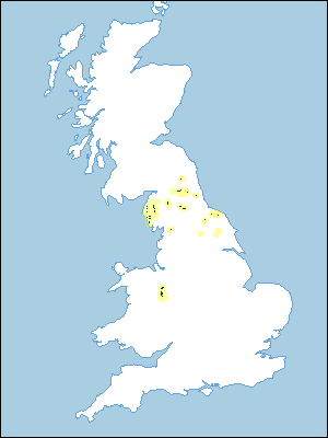
These soils cover 161 km², in the Tyne valley, the Eden valley near Penrith, Teesdale, some Lake District valleys and the North York Moors. In wetter western districts there is a larger proportion of podzolic soils than elsewhere, the Ellerbeck series, typical brown earths, giving way to typical brown podzolic soils of the Baschurch series. Stoniness and texture vary, and where the drift becomes less stony and deeper over the gravels, Ellerbeck soils are replaced first by the Hall series, typical brown earths, and then by the Wick series. Sandy and sandy-gravelly soils, represented by the Newport and Netherby series respectively, are also present in places. The stones are hard sandstone, greywacke or igneous rock. Low-lying places contain the seasonally waterlogged loamy-gravelly Greengill series. Small areas of alluvium, with the Eversley series, also occur. On the North York Moors, the gravelly Rushwick series is present.
Soil Water Regime
The principal soils are well drained (Wetness Class I) and permeable. Excess winter rainwater quickly soaks in and there is little surface run-off. Profile available water, which is variable and affected by stoniness, is less than 100 mm in Ellerbeck and Baschurch soils, and less than 150 mm in the Hall series. Except in the Lake District and Pennines, the soils are slightly to moderately droughty for grass, depending on the potential moisture deficit.
Cropping and Land Use
This is easily worked land suitable for cultivation except where the climate is too wet or the slope too steep. Land use varies from livestock production and dairying, in wetter districts, to some arable in the drier districts. Natural fertility is poor and the stony topsoil can severely wear farm implements and create difficulty with cultivations and harvesting. The chief restriction to grass growth is the small amount of available soil water, but in the wetter western districts this is ameliorated by the climate. The soils are resistant to poaching and can carry large numbers of stock. Where wet soils are extensive this association is especially valuable in winter, as the land may be used by stock with little damage to either soil structure or the grass sward. The soils are very suitable for slurry acceptance, except where very stony at the surface or where the ground slopes steeply. The association is under trees near Hexham, Northumberland where larch, Douglas fir and beech, ash and sycamore are the principal species planted.
0541u ELLERBECK
Distribution Map
 |
Note that the yellow shading represents a buffer to highlight the location of very small areas of the association.
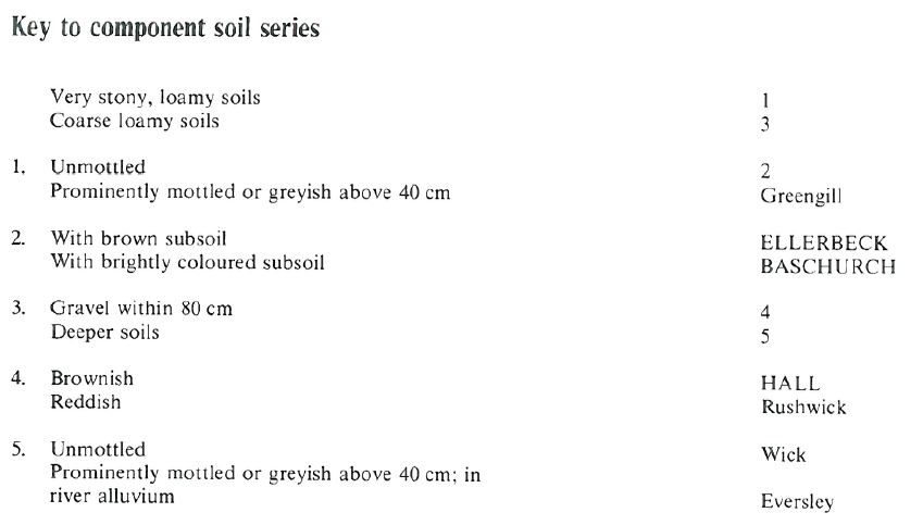
Keys to component soil series
Northern Region
 |
All information Copyright, Cranfield University © 2024
Citation: To use information from this web resource in your work, please cite this as follows:
Cranfield University 2024. The Soils Guide. Available: www.landis.org.uk. Cranfield University, UK. Last accessed 20/04/2024
