
Soil Associations
0541x EAST KESWICK 1
Soil and site characteristics
Deep well drained fine loamy soils and similar soils with slowly permeable subsoils and slight seasonal waterlogging. Some coarse loamy soils affected by groundwater.
Geology
Drift from Palaeozoic sandstone and shale
Cropping and Land Use
Cereals and grassland in the Northern Region; stock rearing on permanent grassland in Wales.
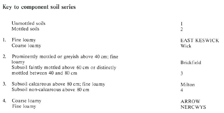
Component soil series
| Subgroup | Series name | Percentage | WRB 2006 link |
|---|---|---|---|
| 5.41 | EAST KESWICK | 45% | Eutric Cambisols |
| 5.42 | NERCWYS | 30% | Eutric Stagnic Cambisols |
| 5.43 | ARROW | 10% | Eutric Endogleyic Cambisols |
Covers 804 km2 in England and Wales
Soilscapes Classification
| 6 |
Freely draining slightly acid loamy soils |
0541x EAST KESWICK 1
Detailed Description
This association comprises deep fine loamy brown earths with some wetter soils in drift. It has been mapped in North Yorkshire and Wales on gently undulating land. The well drained East Keswick series, typical brown earths in drift with siliceous stones, occupies approximately two-thirds of the association. The seasonally waterlogged Nercwys series, fine loamy stagnogleyic brown earths, and Arrow series, coarse loamy gleyic brown earths, occupy most of the remainder. The association occurs throughout Anglesey and Lleyn where the soils were previously mapped as Gaerwen and Arfon series. The drift thickness varies considerably over short distances and there are isolated exposures of schist and gneissose granite. The soils are often stony, with hard metamorphic and igneous stones. The association is found in the Dwyfach valley and north of Pwllheli on low, hummocky, stony outwash deposits, often with fragipan. West of Llanbedrog, East Keswick soils occur in drift over igneous rocks which locally appear at the surface. Throughout north-west Wales the association occurs mostly below 50 m O.D. but reaches 200 m O.D. near Llanllyfni, where there are some Meline soils. Along the English border on the Severn and Vyrnwy at 60 to 80 m O.D. small areas of glaciofluvial drift underlain by gravel are included. In south Wales the association is most extensive on Gower, where there is only a slight predominance of the East Keswick series. Nercwys and occasionally Brickfield soils occur where the drift is more compact and less permeable. Some topsoils are silty, reflecting a probable loessial contribution. Small areas of the association are mapped elsewhere, in drift over limestone near Merthyr Tydfil and in morainic material north of Swansea. Milton soils are rarely associated with this map unit in Wales.
The association has been mapped in North Yorkshire over an area of 289 km², between the Tees and Nidd and extending into Swaledale and Wensleydale. Around Bedale there are several glaciofluvial mounds with Wick soils and, near Studley Roger, Escrick soils are in reddish till. Some of the soils are calcerous below 60 cm, and around Leyburn and Catterick there are small areas of calcareous Milton soils in drift containing Carboniferous and Magnesian Limestone.
Soil Water Regime
East Keswick soils are well drained (Wetness Class I), whereas seasonal waterlogging is a feature of lower horizons in Nercwys and Arrow soils. Natural drainage in the Nercwys is hampered by the slowly permeable subsoil. The land readily absorbs winter rainwater. Available water is adequate for arable crops in normal years in most places, but in Powys drought restricts grass growth in summer.
Cropping and Land Use
The association is predominantly under medium to long-term grassland with about one-fifth under cereals. There is a small acreage of potatoes for local sale and, on the Gower and Anglesey, some early potatoes and field vegetables. The soils are well suited to grassland; the large retained water capacity of topsoils leads to a slight poaching risk but this can be minimized by control of grazing during wet weather. Potential yields are large in west and south Wales and there is a long autumn flush. In average years, the soils will be fit for slurry spreading for a few days in most winter months as well as throughout summer. The field capacity period is mostly above 200 days and soil conditions for cultivation are best in autumn. The well developed structure, high organic matter content and free drainage of topsoils make cultivation possible for spells in winter and spring without damaging structure. Locally the hard stones cause machinery to wear rapidly and make harvesting root crops difficult. In normal years crops will not be affected by lack of moisture unless rooting depth is restricted by fragipan.
0541x EAST KESWICK 1
Distribution Map
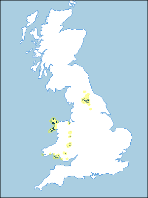 |
Note that the yellow shading represents a buffer to highlight the location of very small areas of the association.
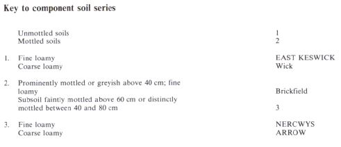
Keys to component soil series
Northern Region
 |
Wales
 |
All information Copyright, Cranfield University © 2024
Citation: To use information from this web resource in your work, please cite this as follows:
Cranfield University 2024. The Soils Guide. Available: www.landis.org.uk. Cranfield University, UK. Last accessed 19/04/2024
