
Soil Associations
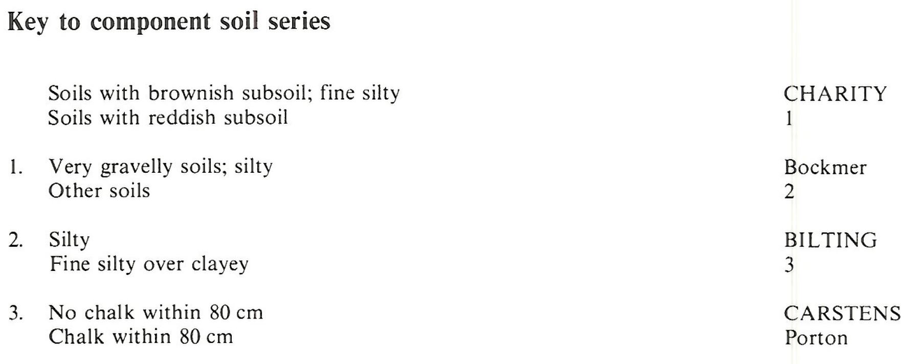
0571l CHARITY 1
Soil and site characteristics
Well drained fine silty and fine silty over clayey soils, locally very flinty some shallow over flint gravel.
Geology
Flinty silty drift
Cropping and Land Use
Continuous cereals and cereal and grassland rotations in Sussex and Hampshire; some dairying in Dorset and Devon.
Component soil series
| Subgroup | Series name | Percentage | WRB 2006 link |
|---|---|---|---|
| 5.71 | CHARITY | 60% | Chromic Luvisols |
| 5.81 | CARSTENS | 20% | Profundic Chromic Luvisols |
| 5.81 | BILTING | 20% | Siltic Chromic Luvisols |
Covers 176 km2 in England and Wales
Soilscapes Classification
| 6 |
Freely draining slightly acid loamy soils |
0571l CHARITY 1
Detailed Description
This association occurs in Southern England on deep flinty non-calcareous silty drift, which, in most places, overlies the Chalk on its gently sloping lower dipslopes. In parts of Dorset, Devon, Somerset and Wiltshire it is also found on higher ground over Upper Greensand. Charity soils, deep, brown, flinty fine silty typical argillic brown earths, are dominant. Intimately associated with these are Carstens and Bilting series, typical paleo¬argillic brown earths. Both are fine silty with reddish or reddish brown subsoils but Carstens soils are clayey at depth.
The association occurs mainly on the dipslope of the Chalk in Dorset, near Dorchester and Winterbourne Kingston, where aeolian silty drift covers river terrace deposits. Charity and Bilting soils are dominant although Carstens soils are found where Clay-with-flints is present on high-level terraces. Fine silty over clayey Porton soils occur on slopes where the Clay-with-flints thins over chalk and gravelly Bockmer soils are where the silty drift is thinner. In east Wiltshire, there is a small area around Ludgershall where stony silty material in the wide dry valleys and on low ridges gives Charity series, with shallow Porton series rather than the deeper Carstens series as the main subsidiary soil. The association also occurs around Chard, Somerset and on the Wiltshire-Somerset border between Warminster and Penselwood. In these places, stony silty drift mantles the Upper Greensand dipslope down to quite low elevations. Some soils have very stony subsoils and most have chert as well as flint stones.
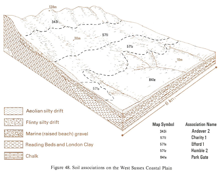
The association extends in a broad belt up to 3 km wide from Havant to Arundel at the foot of the South Downs dipslope in West Sussex. It comprises the land mapped as Charity and Strettington series, and is level or gently sloping. The flinty silty Head is particularly stony in places giving gravelly Bockmer soils. Well drained fine silty over clayey Porton soils are found occasionally where chalk occurs within the soil profile. In Hampshire, the association is sporadic in distribution, and confined to a few valley sides where Charity and Bilting as well as Carstens soils are developed in thick silty drift.
Soil Water Regime
The soils are naturally well drained (Wetness Class I) and there is little surface run-off. Where arable soils have been heavily compacted, pans can cause surface waterlogging, especially on level or gently sloping land. Comparison of the plant available water with crop-adjusted mean potential soil moisture deficits shows that the principal soils are slightly droughty for potatoes and grass and non-droughty for cereals in the drier east, whereas in the wetter west only grass is checked in an average year. The small areas of gravelly Bockmer soils are the most droughty.
Cropping and Land Use
All the principal soils are easy to work but because of their silty texture and weak soil structure they cap and pan easily and are unsuited for sequential direct drilling of cereals. Surface stones help to reduce the degree of capping, however. Crops growing in very stony soils suffer severe drought stress in summer and tyres and implements wear excessively. Seed-bed preparation, precision drilling and the harvesting of root crops are also hindered. In most years, there are long periods in the autumn when cultivation is possible, but opportunities are restricted in the spring, particularly in wet years. Favourable conditions for tillage continue in the drier east for about two weeks longer than in the wetter west. Arable soils require liming from time to time to correct natural acidity. Levels of magnesium, potassium and phosphorus are naturally low, but have been increased by fertilizer applications (Cope 1976). A wide range of crops are grown but locally stoniness precludes root crops. The effects of exposure also limit the choice of crop on the highest ground. In the wetter west, grass crops suffer little from drought and yields are usually large. There is a moderate risk of poaching in a normal year but the risk is considerable in a wet season. In the drier east, yields are limited by summer drought, but the land can be safely stocked in spring and autumn without risk of poaching. There is a useful autumn flush of grass in most districts and the land is suitable for light winter stocking.
0571l CHARITY 1
Distribution Map
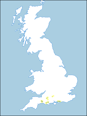 |
Note that the yellow shading represents a buffer to highlight the location of very small areas of the association.
Keys to component soil series
South Western Region
 |
South Eastern Region
 |
Typical Landscapes
South Eastern Region
 |
All information Copyright, Cranfield University © 2024
Citation: To use information from this web resource in your work, please cite this as follows:
Cranfield University 2024. The Soils Guide. Available: www.landis.org.uk. Cranfield University, UK. Last accessed 25/04/2024
