Soil Associations
0571p ESCRICK 1
Soil and site characteristics
Deep well drained reddish coarse loamy soils. Some similar soils with slowly permeable subsoils and slight seasonal waterlogging. Some slowly permeable seasonally waterlogged reddish fine silty soils.
Geology
Reddish till
Cropping and Land Use
Cereals and short term grassland; some fruit, potatoes and hops.
Component soil series
| Subgroup | Series name | Percentage | WRB 2006 link |
|---|---|---|---|
| 5.71 | ESCRICK | 40% | Chromic Luvisols |
| 5.72 | NUPEND | 14% | Chromic Endostagnic Luvisols |
| 7.11 | VERNOLDS | 10% | Chromic Eutric Albic Luvic Stagnosols |
Covers 514 km2 in England and Wales
Soilscapes Classification
| 6 |
Freely draining slightly acid loamy soils |
0571p ESCRICK 1
Detailed Description
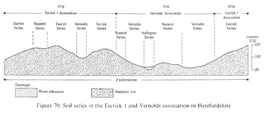
This association contains deep well drained coarse loamy soils developed in reddish till and Head deposits. It is extensive in Herefordshire and south Shropshire occupying 489 km² mainly in undulating topography below 275 m O.D. The till, deposited by a lobe of Devensian ice from the Wye valley, is often slightly calcareous at depth and composed of local Devonian and Silurian rocks with a few far-travelled Welsh erratics. Many of the stones are soft siltstones and fine sandstones which readily weather into a reddish micaceous coarse loamy matrix with a large proportion of silt. The Head deposits which are very similar to the till in composition, are found particularly in the Church Stretton district at the foot of Silurian scarps overlooking adjacent Devonian rocks. The coarse loamy Escrick soils, typical argillic brown earths, formerly described as Wootton series (Hodgson 1972) are predominant but fine loamy Newbiggin soils are locally extensive. Stagnogleyic argillic brown earths, Nupend series, with their faintly mottled slightly porous subsoils are common on level or gently sloping ground often associated with typical stagnogleys, Vernolds series, on lower slopes and in depressions in the landscape. The till and Head deposits are generally thick but the underlying Devonian rocks occasionally protrude to give fine silty Bromyard soils developed in Devonian silty shale and siltstone. The typically undulating topography is crossed by several smooth, flat-topped ridges which formed as terminal moraines notably at Staunton-on-Wye, Orleton and Dorstone. These are generally composed of stoneless outwash silts and sands giving silty soils described as Dore series by Palmer (1972). More commonly profiles are slightly stony throughout but moderately stony soils are extensive around Moccas and elsewhere where upper layers of the drift deposits have been water sorted during and after the retreat of Devensian ice. Where kettle moraine is well developed, as around Shobdon and Bredwardine, typical stagnogley soils (Vernolds series) often fringe water filled hollows. Outwash gravels, mainly derived from Devonian argillaceous limestones and calcareous sandstones, form low knolls and narrow ridges within the ground moraine on which fine loamy typical argillic brown earths (Peaton series, Palmer 1972) and coarse loamy typical brown calcareous earths (Little Hereford series, Palmer 1972) are usually developed. On the southern and western flanks of the Clee Hills in Shropshire Newbiggin soils predominate. These are fine loamy soils, developed in Head derived from dolerite, Devonian silty shale and Carboniferous sandstone, and were originally described as Greete and Haymore series by Hodgson (1972). They occur on crests and narrow interfluves and on terrace-like features within the valleys radiating from the hills .
Soil Water Regime
While the Escrick series is mainly well drained (Wetness Class I) it can suffer slight waterlogging locally (Wetness Class II). Nupend series with slowly permeable subsoil horizons is seasonally waterlogged (Wetness Class II and III) but with underdrainage is Wetness Class II. The slowly permeable Vernolds series is waterlogged for long periods during the winter (Wetness Class IV and V) although with underdrainage it is seasonally waterlogged (Wetness Class III). Escrick association readily absorbs winter rainfall except on steep slopes or on compacted arable land where there is some surface run-off when rain is heavy.
Cropping and Land Use
These deep valuable soils are used for a wide range of crops and under good management large yields can be obtained. Mixed farming is usual with cereals the most important arable crop, though some root and horticultural crops and soft fruit are grown. Hop-yards and commercial orchards, especially dessert and cider apples, are also found. Cultivations are easy and give a good tilth but heavy rain causes surface slaking because the soils contain large amounts of silt and fine sand. Recently ploughed or sparsely vegetated fields on moderate slopes are susceptible to rill and gully erosion especially where surfaces are slaked. Small retained water capacities of surface horizons and rapid permeability allow cultivations during rain-free periods in the winter and early spring. Autumn usually provides ample opportunity for landwork, but there is also a useful period in spring for necessary work except in wet years. Cereals and sugar beet can be grown with little risk of drought but potatoes are moderately droughty. Approximately half the land is under ley or permanent grassland which yields well for much of the year but the three main soils are moderately droughty for grass and growth is restricted in dry summer months. Nevertheless good crops of hay can be obtained. The small amounts of water held in the topsoils ensure that bearing strengths on long term pastures are sufficient to allow grazing throughout most of the year. Only during the wettest winter periods therefore is there any risk of poaching. New leys are more at risk and increased care in the timing of grazings and stocking densities is then necessary. Although these soils are mainly farmed there are small estate woodlands and game coverts dotted throughout the landscape. Many tree species show excellent growth on Bromyard and Escrick soils and specimen trees, in old parkland at Oakley Park, Ludlow measured by Mitchell (1963) were the tallest of their kind in Britain. They include Scots pine (Pinus silvestris) 36.6 m, Corsican fir (Abies nordmaniana) 40.2 m and small-leaved lime (Tilia cordata) 34.4 m. On Escrick soils at Easthampton, near Shobdon Herefordshire a sessile oak (Quercus sessiliflora) held the record for the largest girth (8.9 m).
0571p ESCRICK 1
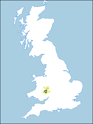
Distribution Map
 |
Note that the yellow shading represents a buffer to highlight the location of very small areas of the association.
Typical Landscapes
Midlands
 |
All information Copyright, Cranfield University © 2024
Citation: To use information from this web resource in your work, please cite this as follows:
Cranfield University 2024. The Soils Guide. Available: www.landis.org.uk. Cranfield University, UK. Last accessed 25/04/2024
