
Soil Associations
0572b MIDDLETON
Soil and site characteristics
Reddish fine silty soils with slowly permeable subsoils and slight seasonal waterlogging over shale and siltstone. Some similar fine loamy soils slowly permeable seasonally waterlogged fine silty soils in places.
Geology
Devonian reddish silty shale and siltstone
Cropping and Land Use
Stock rearing on permanent and short term grassland; some cereals.
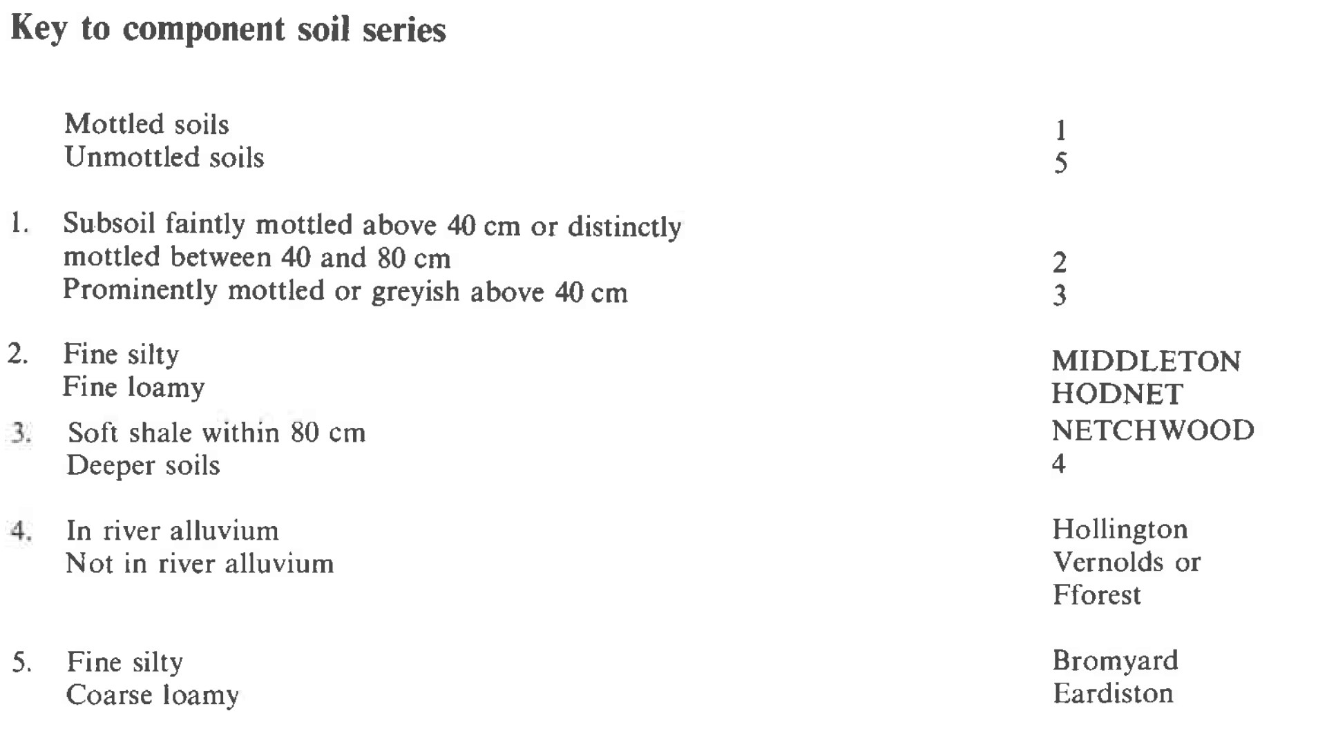
Component soil series
| Subgroup | Series name | Percentage | WRB 2006 link |
|---|---|---|---|
| 5.72 | MIDDLETON | 55% | Chromic Endostagnic Luvisols |
| 5.72 | HODNET | 18% | Chromic Endostagnic Luvisols |
| 7.11 | NETCHWOOD | 12% | Siltic Eutric Luvic Stagnosols |
Covers 112 km2 in England and Wales
Soilscapes Classification
| 8 |
Slightly acid loamy and clayey soils with impeded drainage |
0572b MIDDLETON
Detailed Description
Reddish fine silty and fine loamy soils on soft red Devonian silty shales and siltstones, are grouped as the Middleton association. The shales are micaceous and slightly calcareous where unweathered and contain a few thin interbedded argillaceous limestone bands and nodules. There are greenish grey blotches and streaks throughout and thin impersistent lenses of micaceous sandstone are common. Surface wetness, typical of this association, is often exacerbated by water seepage from these sandstones. The association occupies 112 km² in the Welsh Borderland and in small areas of sout-east Wales, mainly on broad flat ridge crests or on gentle slopes in basin-like receiving sites often around the heads of small valleys. Stagnogleyic argillic brown earths are dominant, the Middleton series developed in material weathered from silty shale being more widespread than the similar but fine loamy Hodnet series, which is formed from interbedded sandstone and shale. Wet often rush infested patches contain Netchwood soils classified as typical stagnogley soils. Also included are coarse loamy, well drained soils over hard sandstone, the Eardiston series with Vernolds series in deep silty drift in flush sites. The proportion of Netchwood soils is greatest on the flanks of the Clee Hills on Dittonian strata which contain more mudstones than elsewhere in the Devonian succession. Clayey soils similar to the Netchwood series are often present here together with the Bromyard and Eardiston series. In valley heads and on other gentle concave slopes the proportion of soils developed in deep drift and silty alluvium increases and Vernolds, Fforest and Hollington series are identified. These drift soils often form a narrow strip between the alluvial gley soils, mainly Hollington series, along the streams and Middleton or Hodnet series upslope.
Two small occurrences of 2 km² are mapped in Gloucestershire near Kempley where valley footslopes along the Kempley and Preston brooks have predominantly Middleton series, with silty typical alluvial gleys, Hollington series, along the narrow floodplains. Bromyard seriesoccurs on steeper slopes and there are localized patches of calcareous gravels giving typical argillic brown earths, Peaton series
Soil Water Regime
Middleton and Hodnet series are seasonally waterlogged (Wetness Class III) but respond well to artificial drainage. Netchwood series is waterlogged for long periods during the winter (Wetness Class IV) and, in districts where the field capacity period is greater than 200 days, waterlogging continues into the growing season on sites without underdrainage (Wetness Class V). Surface wetness is caused by the slow permeability of subsoil horizons. Mole drains do not persist in these silty subsoils so expensive tile drainage with backfill is often needed. However, interception of springs can be a simple and cheaper alternative often offering substantial improvement. Where slope allows excess winter rainwater moves horizontally above the dense subsoil horizons.
Cropping and Land Use
Land use is restricted to grassland and occasional cereal crops which on underdrained Middleton and Hodnet soils produce good yields. Substantial patches of wetter Netchwood soils within a field inhibit ploughing and such fields often contain rushes and other moisture loving plants. Around Hereford both Middleton and Hodnet series are moderately droughty for grass and growth is checked during dry summers. Further north around the Clee Hills there is no drought limitation but poaching and compaction are a problem when grazing early and late in the season. There is negligible poaching risk around Hereford except for the wet Netchwood soils. Thus careful management is necessary in districts with more than 175 field capacity days. Cultivations are relatively easy and a good tilth can be obtained with normal machinery. Water retentive topsoils and slow subsoil permeability make working between December and March unadvisable. With care spring tillage is possible around Hereford on Middleton and Hodnet soils but autumn working is more flexible and allows safe cultivation even in wet years. On the flanks of the Clee Hills opportunities for spring tillage are negligible and the period for autumn working is still short and cultivations are likely to cause structural damage in at least one year in four.
0572b MIDDLETON
Distribution Map
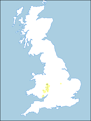 |
Note that the yellow shading represents a buffer to highlight the location of very small areas of the association.
Keys to component soil series
Midlands
 |
All information Copyright, Cranfield University © 2024
Citation: To use information from this web resource in your work, please cite this as follows:
Cranfield University 2024. The Soils Guide. Available: www.landis.org.uk. Cranfield University, UK. Last accessed 18/04/2024
