
Soil Associations
0634 SOUTHAMPTON
Soil and site characteristics
Well drained very acid, very flinty sandy soils with bleached subsurface horizon. Some very acid sandy over clayey soils with slowly permeable subsoils and slight seasonal waterlogging.
Geology
Plateau gravel and river terrace drift
Cropping and Land Use
Lowland heath habitats, coniferous and deciduous woodland; some improved grassland; gravel extraction; military use.
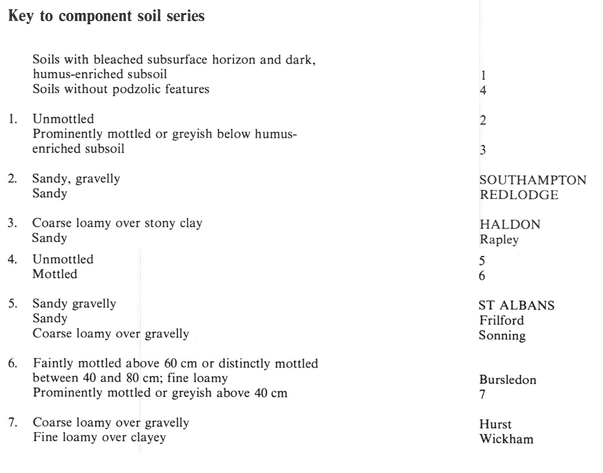
Component soil series
| Subgroup | Series name | Percentage | WRB 2006 link |
|---|---|---|---|
| 6.34 | SOUTHAMPTON | 45% | Episkeletic Ruptic Umbric Albic Podzols |
| 6.31 | REDLODGE | 12% | Albic Podzols |
| 6.43 | HALDON | 10% | Ruptic Endostagnic Albic Podzols |
| 5.54 | ST ALBANS | 10% | Chromic Skeletic Luvisols |
Covers 191 km2 in England and Wales
Soilscapes Classification
| 14 |
Freely draining very acid sandy and loamy soils |
0634 SOUTHAMPTON
Detailed Description
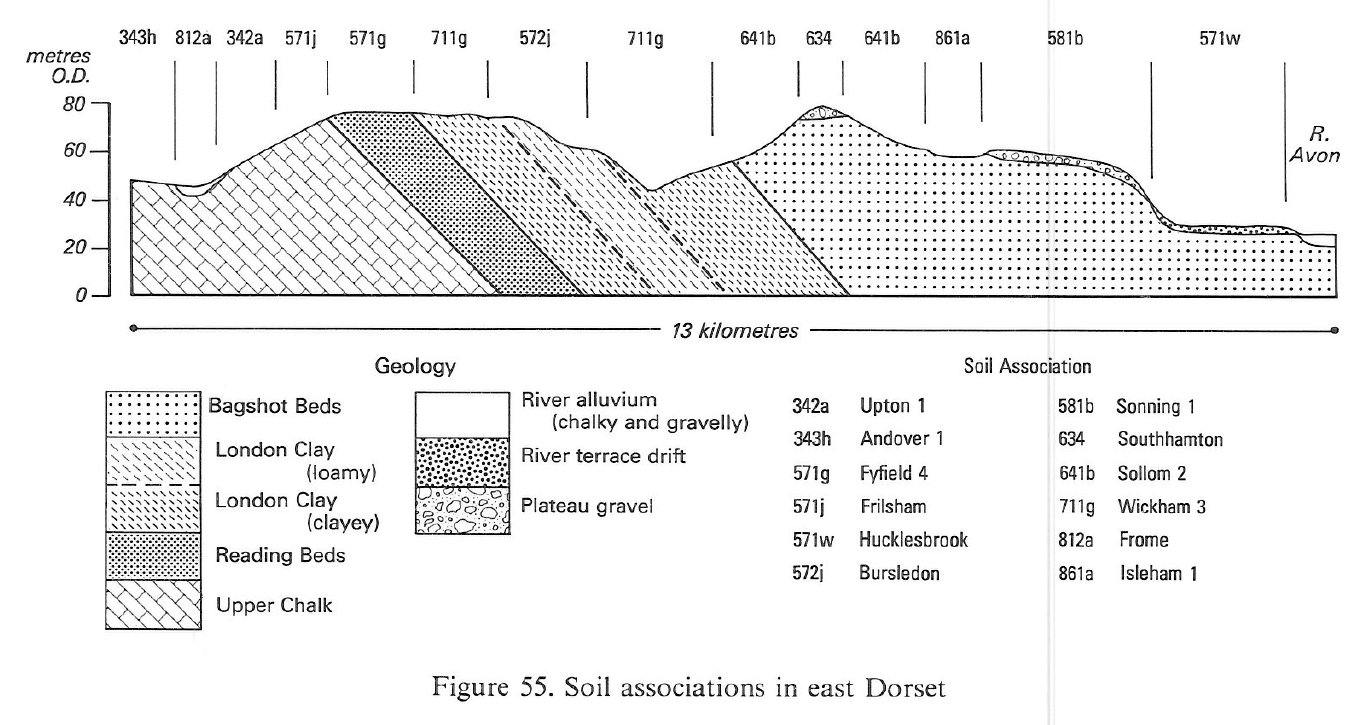
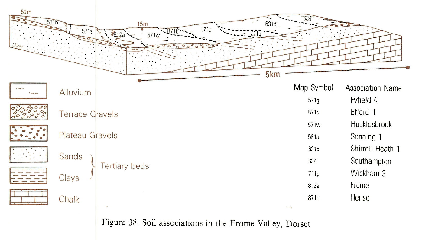
These very stony, very acid, sandy soils developed in Plateau gravels and river terrace drift are mainly under heath and coniferous woodland. They are found in Berkshire, Surrey and Hampshire and also in Dorset, where they cap high ground between the rivers Avon, Stour, Piddle and Frome. A small area is mapped in the Bovey Basin in Devon. Most land is level or gently sloping and rises to over 200 m O.D. at Caesar's Camp near Farnham and to 237 m O.D. on Black Down west of Dorchester. The gravels, which rest on Tertiary deposits are thick and periglacially disturbed giving festoons and infilled ice wedges. Sandy gravelly Southampton soils, paleo-argillic podzols, predominate on level ground. Stony, sandy Redlodge soils, humo-ferric podzols in Head, and flinty coarse loamy over clayey Haldon soils, stagnogley podzols, in gravelly material mixed with the underlying Tertiary deposits, are found mainly near plateau and ridge margins. The included gravelly St Albans soils, argillic brown sands, are usually on farmed land.
In Dorset, the Plateau gravels form flat terraces between 30 m and 200 m O.D. They include bands of sand and clay, and have been extensively worked for gravel and the Tertiary sand below. Southampton soils are most common but they often pass laterally into similar soils with thin, undulating ironpans. Clayey bands within the gravels give the wetter Haldon, Oak, Essendon and locally stoneless silty Bolderwood soils. On some lower terraces there are well drained coarse loamy over gravelly Hucklesbrook soils.
In west Berkshire, Bursledon and Wickham soilsare included on the sides of valleys which cut through the river terrace gravels to the underlying London Clay. North of Fleet, Rapley and Redlodge soils are present. Wetter sandy Blackwood and Isleham soils affected by groundwater are developed on narrow valley floors. Sandy Frilford soils occur, fringing the gravelly heathland between Yateley and Hawley. Most of the land in Berkshire was included in the Southampton association.
Soil Water Regime
Cropping and Land Use
Much of the land under heath and some coniferous woodland has public access. There are extensive sand and gravel workings. Many heaths are designated Sites of Special Scientific Interest (Ratcliffe 1977). Dry heath is most common with ling dominant but there are small amounts of humid and wet heath on valley sides. On Canford and Holt Heaths, gorse, once cut for bedding, has spread since cutting ceased. The vegetation is partly controlled by burning, and bell heather is commonly associated with ling in burnt areas. Patches of scrub woodland chiefly of Scots pine with birch and oak are locally common.
Because the soils are stony, droughty, very acid and poor in nutrients the choice of trees is restricted to Scots, Corsican or Lodgepole pine. Before afforestation, heathland soils are usually ploughed to break up pans and destroy the heather which inhibits nitrate production by mycorrhiza (Handley 1963) and so restricts the growth of young trees. Nitrogen and particularly phosphorus fertilizers are needed to promote the vigorous early growth that competes with weeds and encourages better rooting.
The small amount of farmland is principally pasture and rough grazing, though cereals and, with irrigation, vegetables, are grown on Sonning soils in Berkshire.
0634 SOUTHAMPTON
Distribution Map
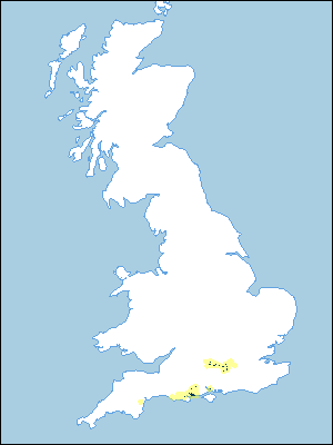 |
Note that the yellow shading represents a buffer to highlight the location of very small areas of the association.
Keys to component soil series
South Western Region
 |
South Eastern Region
 |
Typical Landscapes
South Western Region
 |
South Western Region
 |
All information Copyright, Cranfield University © 2024
Citation: To use information from this web resource in your work, please cite this as follows:
Cranfield University 2024. The Soils Guide. Available: www.landis.org.uk. Cranfield University, UK. Last accessed 16/04/2024
