
Soil Associations
0712h FOGGATHORPE 1
Soil and site characteristics
Slowly permeable seasonally waterlogged clayey and fine loamy over clayey soils, often stoneless.
Geology
Glaciolacustrine drift and till
Cropping and Land Use
Grassland and cereals in Northumberland; dairying on permanent grassland in Wales.
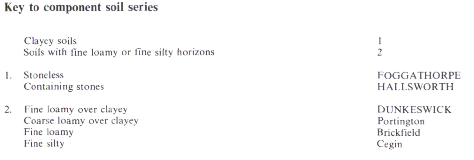
Component soil series
| Subgroup | Series name | Percentage | WRB 2006 link |
|---|---|---|---|
| 7.12 | FOGGATHORPE | 50% | Clayic Eutric Stagnosols |
| 7.12 | HALLSWORTH | 30% | Clayic Eutric Stagnosols |
| 7.11 | DUNKESWICK | 20% | Eutric Albic Luvic Stagnosols |
Covers 289 km2 in England and Wales
Soilscapes Classification
| 18 |
Slowly permeable seasonally wet slightly acid but base-rich loamy and clayey soils |
0712h FOGGATHORPE 1
Detailed Description
This association is dominated by seasonally waterlogged clayey, often stoneless soils in till and glaciolacustrine clay. It occurs on flat or gently sloping ground, and is restricted to south-east Northumberland, Tyne and Wear, and Durham with smaller areas in basin sites in south-west Wales and near Clitheroe in Lancashire. The principal soils are the slowly permeable, stoneless Foggathorpe series on glaciolacustrine clay, and the Hallsworth series on clayey till. Slowly permeable fine loamy over clayey soils, Dunkeswick series, also occur but are usually of secondary importance. In Wales the association is dominated by poorly drained clayey stoneless soils on glaciolacustrine clay and slightly stony soils on till. It occurs mainly in flat or gently sloping basin sites around Cardigan and Whitland, between 15 and 120 m O.D. Some areas of more accentuated relief are the remains of pingos. These were ice-cored mounds formed in permafrost during the last glaciation, which collapsed on melting to leave basins surrounded by arcuate ridges. The soil pattern is locally complex although most of the ground is taken up by the two main series. The Hallsworth series, pelo-stagnogley soils, dominates in slightly undulating country where soils are on slightly stony till. The Foggathorpe series, pelo-stagnogley soils, is more widespread in the flatter areas where lacustrine clay overlies the till. The Dunkeswick series, typical stagnogley soils, occurs sporadically where fine loamy material more than 30 cm thick overlies the clay. It is most common where the association adjoins the Cegin association. Elsewhere, particularly around the pingo ridges near Cardigan, occasional profiles of the fine silty Cegin series and coarse loamy over clayey Portington series also occur. Locally sandy strata have been recorded giving Blackwood series.
Although till and glaciolacustrine clay are predominant, the association also occurs on laminated flow till, Pelaw Clay around Blyth, Northumberland, and in Tyne and Wear. Altitude varies from around 6 m O.D. at the coast to 150 m O.D. near Rothbury. The land near the coast is somewhat exposed. The soil pattern is very simple, with most ground being taken up by the two main series. The Foggathorpe series, pelo-stagnogley soils, is on the widespread flat land where lacustrine clay overlies the till. The Hallsworth series, pelo-stagnogley soils, predominates in gently undulating country where soils are on slightly stony till. The Dunkeswick series, typical stagnogley soils, occurs where fine loamy material more than 30 cm thick overlies the clay. It can occur randomly but is more prevalent where the association adjoins the slightly coarser soils of the Brickfield 3 association. In places, profiles of the fine loamy Brickfield series occur. Many soils have been modified by the tipping of fly-ash and, near towns, domestic rubbish; others have been replaced following opencast coal mining.
Soil Water Regime
Nearly all the soils are slowly permeable so they suffer seasonal, sometimes severe, waterlogging. Drainage is essential, especially in Foggathorpe and Hallsworth soils (Wetness Class IV) if they are to be used other than in summer. Although the Dunkeswick series is less frequently waterlogged it is also in Wetness Class IV and land drainage is essential. Because of the slow permeability, excess winter rain runs off rapidly or remains.
Cropping and Land Use
The clayey texture and surface wetness of the Foggathorpe and Hallsworth series restrict cropping to grass and, here and there a little barley. Much of the land is in rough grazing, particularly on wetter ground where reseeding is difficult. Here the dense root mat, characteristic of old pastureland, reduces the risk of poaching. Potatoes and root crops can be grown but yield well in exceptional years only. Present farming reflects these limitations. Where there are more Dunkeswick soils the deeper fine loamy topsoil gives greater cropping flexibility.
In south-west Wales there are few opportunities to work this land in suitable conditions in either spring or autumn. Cultivations for pasture reseeding are best done during summer, but care is needed to minimize structural damage which will inhibit germination. Although the soils are best suited to grassland they poach easily when wet. The land is not suited to repeated slurry applications as it is rarely dry enough to prevent severe wheel rutting and the rapid run-off would cause pollution of streams. The soils are only moderately fertile as they can be deficient in phosphorus; they are acid unless limed regularly. Unless drained, the slowly permeable clayey soils are poorly-suited to trees which tend to root shallowly and are thus vulnerable to the wind.
In Durham and Northumberland there has been much opencast coal extraction. The large clay content of the soils means that great care is needed, particularly to preserve the topsoil and, at restoration, to avoid compaction and install adequate drainage systems. Although the land is almost entirely farmed the soils are suited to most coniferous species, but drainage is necessary to encourage rooting for secure anchorage against the wind.
0712h FOGGATHORPE 1
Distribution Map
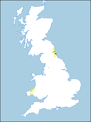 |
Note that the yellow shading represents a buffer to highlight the location of very small areas of the association.
Keys to component soil series
Wales
 |
Northern Region
 |
All information Copyright, Cranfield University © 2024
Citation: To use information from this web resource in your work, please cite this as follows:
Cranfield University 2024. The Soils Guide. Available: www.landis.org.uk. Cranfield University, UK. Last accessed 20/04/2024
