
Soil Associations
0813c FLADBURY 2
Soil and site characteristics
Stoneless clayey soils variably affected by groundwater some with sandy subsoils. Some similar fine loamy soils. Flat land. Risk of flooding.
Geology
River alluvium
Cropping and Land Use
Stock rearing on permanent grassland; cereals where flood risk low.
Component soil series
| Subgroup | Series name | Percentage | WRB 2006 link |
|---|---|---|---|
| 8.13 | FLADBURY | 40% | Clayic Fluvic Eutric Gleysols |
| 8.13 | STIXWOULD | 25% | Fluvic Clayic Eutric Gleysols |
| 5.62 | TRENT | 20% | Eutric Fluvic Endogleyic Cambisols |
Covers 303 km2 in England and Wales
Soilscapes Classification
| 20 |
Loamy and clayey floodplain soils with naturally high groundwater |
0813c FLADBURY 2
Detailed Description
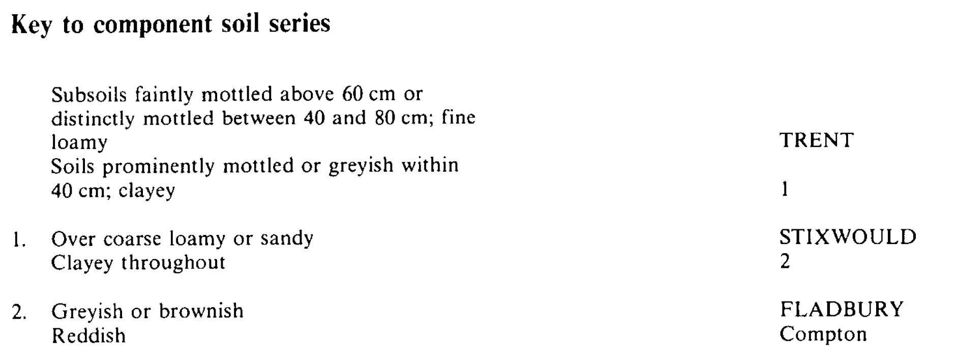
This association, developed in greyish and brownish alluvium, consists of mottled clayey soils, Fladbury and Stixwould series, and subsidiary loamy soils, Trent series. It occurs on the flat floodplains of the River Trent and its tributaries and along several smaller rivers and streams in Lincolnshire. Fladbury series belongs to the pelo-alluvial gley soils and has a mottled, slowly permeable, clayey subsoil. Stixwould soils are similar but pass into coarse loamy or sandy glaciofluvial material within 80 cm depth. Trent series (gleyic brown alluvial soils) is fine loamy, relatively permeable and has no grey mottling in the upper 40 cm. It is found on slightly raised parts of the Trent floodplain.
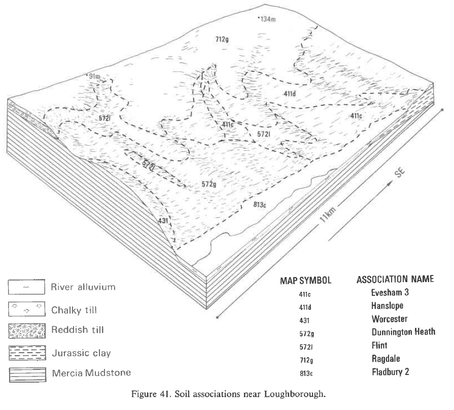
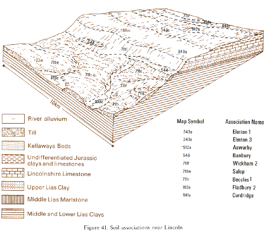
These soils are mapped along the Trent from Gainsborough upstream as far as Rugeley, along the Dove to Uttoxeter, the Tame to Tamworth and the Soar to Leicester. In total they cover 178 km². From Newark upstream as far as Alrewas and along the Dove and Tame there are few Stixwould but many Trent soils and occasional Alun or Wharfe soils on levees. Between Burton upon Trent and Tamworth on low terraces within the floodplain, soils similar to Trent series, but over gravel, are common. Downstream from Newark there are few Trent soils but occasionally on low terraces some Arrow soils are included. Stockwith soils (Reeve and Thomasson 1981) occur near Gainsborough where the clayey alluvium has a thin superficial silty layer of marine alluvium. Trent soils are also rare on the Soar floodplain and along the Trent north-west of Alrewas. In the latter area, Stixwould soils and similar soils over gravel are dominant locally. In the Idle valley north of East Retford most soils are Stixwould series, many having coarse material within 40 cm of the surface. Small fans of reddish Compton soils occur locally where streams draining adjacent Triassic lowlands join the main floodplain.
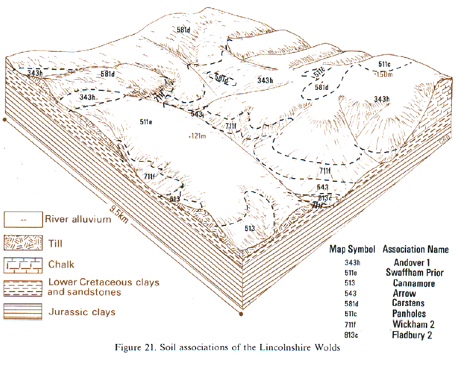
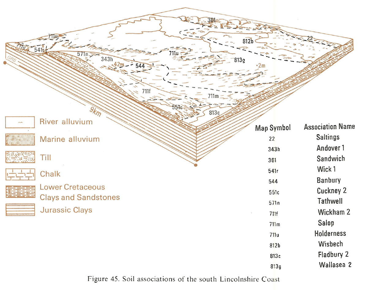
In Lincolnshire the association consists almost entirely of Fladbury and Stixwould series and covers 117 km². Fladbury soils dominate the Trent floodplain between Dunham Bridge and Gainsborough and the Witham alluvium from Grantham to Lincoln. Near Claypole, many Fladbury soils contain buried topsoils and there are local inclusions of Midelney and Thames series. Along the small streams draining into the River Witham, east of Lincoln, Stixwould series is dominant. The association is found in the Till valley north-west of Lincoln, the Bain valley and along the middle and upper reaches of the Great Eau and Steeping River. Where the Bain valley narrows upstream, Conway and Kettlebottom soils are common.
Soil Water Regime
Most soils of the Fladbury series have slowly permeable subsoils and Stixwould soils have slowly permeable upper horizons, but in both cases the primary source of waterlogging is groundwater. Both soils are waterlogged for long periods of the winter (Wetness Class IV) and waterlogging can occur during the growing season (Wetness Class V) in low-lying sites. Because of the permeable substratum, however, groundwater levels in Stixwould series respond more rapidly to changes in river level than those in Fladbury soils. Stixwould soils also respond better to drainage, but in both soils underdrainage is only effective where satisfactory outfalls can be achieved above river level. Trent soils are only waterlogged for short periods in winter (Wetness Class II or III) because they are on slightly higher ground. Along the Trent and its tributaries winter flooding is common, though usually of short duration. Locally the floodplain is protected from minor flooding by low banks. Other parts of the floodplain, such as Beckingham Marshes, are allowed to flood when the river is unusually high, thus easing the flood risk elsewhere. Flooding on Beckingham Marshes is infrequent but can last several weeks. Stixwould soils also respond better to drainage, but in both soils underdrainage is only effective where satisfactory outfalls can be achieved above river level or where pumping, as into the embanked River Witham, is provided. Flooding is infrequent but parts of the Trent floodplain are designated as flood storage areas, as at Lea Marshes near Gainsborough.
Cropping and Land Use
Land use is a mixture of permanent grassland, long leys and cereals. The distribution of cereal growing depends on the local flood risk, climate and presence of Trent soils. There is a gradual change from mainly arable farming east of Nottingham to almost exclusively grassland on the Trent floodplain above Alrewas and in the Dove and Tame valleys. Fladbury and Stixwould soils have a large retained water capacity and a low bearing strength when wet, so under grass there is a serious risk of poaching in winter and grazing is restricted to summer. Nevertheless, they provide useful mowing grass and good summer fattening pastures. Growth is maintained during all but the very driest periods by the reserves of available soil water. Cereal crops are sown in spring into autumn-cultivated ground where there is an appreciable risk of winter flooding but are autumn-sown where there is little flood risk. Cultivations on these soils need careful timing because of soil wetness. Trent soils are relatively easy to work and are less frequently flooded, so where they are extensive within the association they offer greater flexibility in cropping and root crops are occasionally grown. Fladbury, Stixwould and Trent soils are naturally acid and require occasional dressings of lime. They have good reserves of potassium but phosphorus levels depend on recent fertilizer use. Manganese deficiencies in herbage are common on Fladbury and Stixwould soils.
0813c FLADBURY 2
Distribution Map
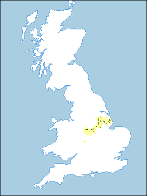 |
Note that the yellow shading represents a buffer to highlight the location of very small areas of the association.
Keys to component soil series
Midlands
 |
Eastern Region
 |
Typical Landscapes
Midlands
 |
Midlands
 |
Eastern Region
 |
Eastern Region
 |
Eastern Region
 |
All information Copyright, Cranfield University © 2024
Citation: To use information from this web resource in your work, please cite this as follows:
Cranfield University 2024. The Soils Guide. Available: www.landis.org.uk. Cranfield University, UK. Last accessed 19/04/2024
