Soil Associations
0815 NORMOOR
Soil and site characteristics
Deep stoneless clayey soils in places with humose surface horizon, often very acid. Flat land crossed by low ridges with deep calcareous silty soils. Groundwater controlled by ditches and pumps. Slight risk of wind erosion.
Geology
Marine alluvium
Cropping and Land Use
Cereals, potatoes and sugar beet.
Component soil series
| Subgroup | Series name | Percentage | WRB 2006 link |
|---|---|---|---|
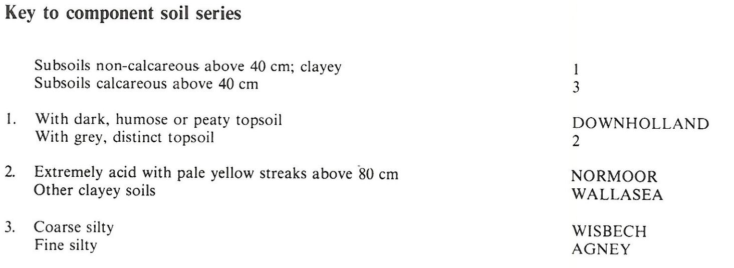
| 8.15 | NORMOOR | 30% | Clayic Fluvic Thionic Gleysols |
| 8.13 | WALLASEA | 25% | Clayic Fluvic Eutric Gleysols |
| 8.51 | DOWNHOLLAND | 20% | Clayic Fluvic Mollic Gleysols |
| 8.12 | WISBECH | 10% | Fluvic Calcaric Gleysols |
| 8.12 | AGNEY | 10% | Fluvic Calcaric Gleysols |
Covers 57 km2 in England and Wales
Soilscapes Classification
| 21 |
Loamy and clayey soils of coastal flats with naturally high groundwater |
0815 NORMOOR
Detailed Description
The Normoor association covers 60 km² near sea level in north Cambridgeshire on clayey marine alluvium. These deposits rest on the Fen Clay (Barroway Drove Beds). There is usually a clear break between the two clays, in places marked by a thin peat band. The upper clayey alluvium was once covered by peat which has largely disappeared through wastage since large scale drainage in the seventeenth century. The landscape is flat without hedges or trees and the fields are bounded by a rectilinear network of ditches which feed into major channels. The association is named after the clayey Normoor series, sulphuric alluvial gley soils, but Downholland series, humic alluvial gley soils, and Wallasea series, pelo-alluvial gley soils, occupy about half the area. Normoor soils have pale yellow mottles of the mineral jarosite on ped faces and around voids which are associated with pH values below 4. The acidity is caused, following drainage, by oxidation of iron sulphides present in the clayey deposits. At first the acidity is neutralized by calcium carbonate occurring naturally in the clay. The acidifying effects of the continuing oxidation of the pyrites are partly counteracted by the natural leaching of sulphates and can be ameliorated by the application of lime.
Although the ground is flat there is a dense network of small ridges 10 to 25 m wide rising up to a metre above the general land surface. These outline a former creek system, now silted up. They form a dendritic pattern clearly visible on aerial photographs. The ridges carry silty calcareous soils of Wisbech and Agney series, both calcareous alluvial gley soils, and occupy up to one-fifth of the land.
The distribution of the Normoor series is patchy, depending on the vertical and horizontal distribution of pyrites in the parent material. Sulphuric Normoor soils can be identified in the field by the presence of pale yellow jarosite mottles, and pH values below 4. Some soils containing jarosite are less acid and similar to "pseudo-acid-sulphate soils" (Brinkman and Pons 1973). These do not suffer from soluble-aluminium toxicity, and where they are identified by measurement of pH values, are classed as Wallasea series. The distribution of Downholland series is also patchy as it depends on variations in the thickness of the remnants of the former peat cover. The proportion of Downholland soils will decrease with time as the organic content of the topsoils wastes further under cultivation.
Soil Water Regime
In most places the water-table is lowered by a system of ditches, arterial drains and pumps so the clayey soils develop strong vertical cracking during summer and this, combined with the coarse vertical pores formerly occupied by reed stems, makes the soils more permeable than their clayey texture would suggest. They are occasionally or seasonally waterlogged (Wetness Class II or III) in this low rainfall area. Soils with the wettest regimes tend to be in hollows between the former creek ridges, the raised sites of which carry permeable well-drained Wisbech and Agney soils (Wetness Class I). These silty soils have sufficient available water for all crops so are non-droughty, but the component clayey soils are moderately droughty for grass and potatoes, although this may be alleviated to some extent by capillary rise from the ground-water where it remains within 1.5 m depth during the summer. Acid layers in Normoor series restrict rooting and thus the water available to crops.
Cropping and Land Use
Cultivation is possible during most of the autumn and again from late March, with only wet hollows likely to sustain structural damage from early working. Downholland series, with its large organic matter content in the topsoil, has fewer workability limitations than Wallasea and Normoor soils. Capping of the seedbed can occur, mainly on the silty Wisbech and Agney soils on the ridges. Root development may be restricted by the severe acidity and aluminium toxicity of the sulphuric horizons, with an ensuing yield reduction. Like the distribution of the acid soils, however, these effects are likely to be patchy. The association is almost entirely arable, growing cereals, sugar beet and potatoes.
0815 NORMOOR
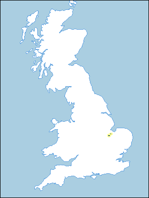
Distribution Map
 |
Note that the yellow shading represents a buffer to highlight the location of very small areas of the association.
Keys to component soil series
Eastern Region
 |
All information Copyright, Cranfield University © 2024
Citation: To use information from this web resource in your work, please cite this as follows:
Cranfield University 2024. The Soils Guide. Available: www.landis.org.uk. Cranfield University, UK. Last accessed 25/04/2024
