
Soil Associations
0841a Curdridge
Soil and site characteristics
Deep stoneless permeable coarse loamy soils with groundwater controlled by ditches. Some slowly permeable seasonally waterlogged clayey soils.
Geology
Jurassic sand and clay
Cropping and Land Use
Cereals, sugar beet and potatoes, some field vegetables.
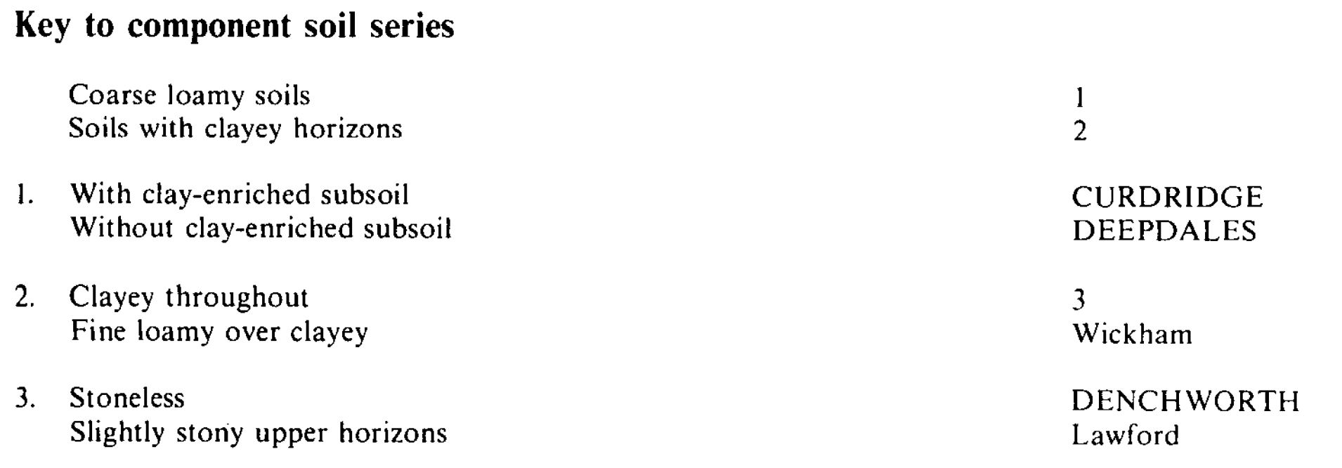
Component soil series
| Subgroup | Series name | Percentage | WRB 2006 link |
|---|---|---|---|
| 8.41 | CURDRIDGE | 35% | Luvic Gleysols |
| 8.31 | DEEPDALES | 25% | Eutric Gleysols |
| 7.12 | DENCHWORTH | 15% | Eutric Vertic Stagnosols |
Covers 59 km2 in England and Wales
Soilscapes Classification
| 22 |
Loamy soils with naturally high groundwater |
0841a Curdridge
Detailed Description
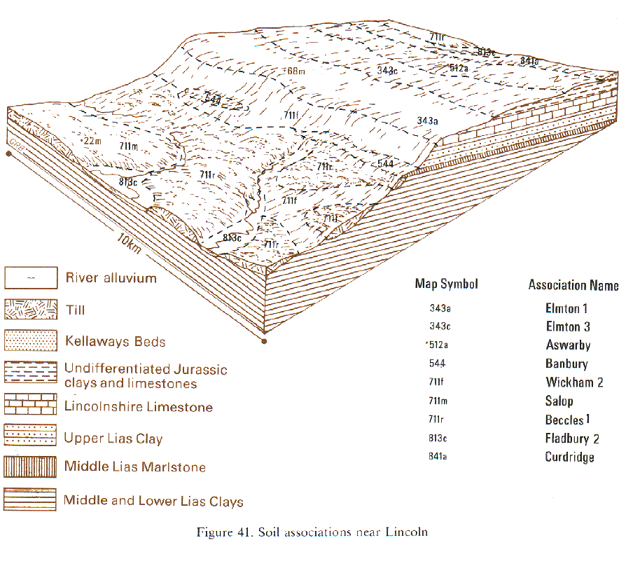
Curdridge and Deepdale series are deep, permeable coarse loamy soils on fine-grained Jurassic sand and sandstone but Denchworth soils are slowly permeable clayey soils on clay-shale. The association occurs on level to gently rolling land on the narrow outcrop of Kellaways sand, sandstone and clay beds extending the length of Lincolnshire into Humberside. Included are Wickham, Lawford and fine sandy Paradise (Clayden and Hollis 1984) soils. Curdridge and Deepdales series are co-dominant in central Lincolnshire. In north Lincolnshire there are more sand and sandstone beds than elsewhere and here fine sandy soils are present. Patches of blown sand also occur in north Lincolnshire giving sandy topsoils. In south Lincolnshire the association adjoins areas of chalky till and locally has inclusions of Lawford and Wickham series where thin Head overlies clay-shale. Many Curdridge soils become finer-textured with depth owing to the presence of interbedded clay and sandstone bands. Many areas have thick clay-shale bands below 1 metre depth.
Soil Water Regime
Curdridge and Deepdales soils are affected by groundwater and are occasionally waterlogged (Wetness Class II). Denchworth soils, even when drained, are seasonally waterlogged for longer periods (Wetness Class III). The soils respond well to drainage but pipe drains in the loamy soils become blocked with fine sand. There is local seepage on some slopes. The main soils are water retentive and are slightly or non-droughty for the main arable crops but moderately droughty for grass. Denchworth soils are more droughty and are very droughty for grass.
Cropping and Land Use
Curdridge and Deepdales soils are easy to cultivate and there are ample opportunities for autumn and spring landwork. The large fine sand content gives rise to surface capping which delays seedling emergence. When worked at unsuitable times, subsurface compaction occurs which reduces infiltration and causes surface wetness. This can be remedied easily by shallow subsoiling. Denchworth soils are more intractable than the other soils and less time is available for cultivation especially in wet springs. The common occurrence of loamy and clayey soils in the same field makes it difficult to time cultivations correctly.
The land is mainly arable. Cereals, sugar beet and potatoes are the main crops but field vegetables, mainly onions, are grown on Curdridge and Deepdales soils. The little grassland is mainly on Denchworth soils which have low potential yield due to droughtiness, poach easily and are not trafficable when wet. With direct drilling the yield of winter cereals is similar to that from conventionally cultivated soils but the yield of spring crops is appreciably reduced. Available phosphorus and potassium levels are moderate. Liming is required periodically on Denchworth soils.
0841a Curdridge
Distribution Map
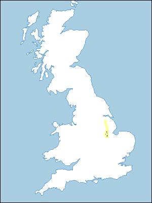 |
Note that the yellow shading represents a buffer to highlight the location of very small areas of the association.
Keys to component soil series
Eastern Region
 |
Typical Landscapes
Eastern Region
 |
All information Copyright, Cranfield University © 2024
Citation: To use information from this web resource in your work, please cite this as follows:
Cranfield University 2024. The Soils Guide. Available: www.landis.org.uk. Cranfield University, UK. Last accessed 18/04/2024
