National Soils Inventory - NSI
NSI Profile Information - NSI Profile

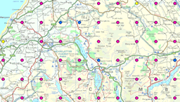
The National Soil Inventory (NSI) profile data is a spatial, point dataset with 6,127 points, located in a 5km grid across England and Wales.
NSI profile provides a very detailed description of the soil profile at the NSI point. From the texture of the soil to the mottle size and colour, many observations are recorded within this fundamental dataset.
Because of the detail of this survey, it is easy to get a good understanding of the soils at the NSI points. Combining this data with chemical NSI data from the NSI topsoil datasets may reveal otherwise hidden trends in the soils of England and Wales.
The fields in the data table, shown below, are repeated for each horizon, or layer, in the soil. This is particularly useful as it allows for easy comparison of the layers as you move down the profile. NSI profile is in essence, a detailed profile description.
How much does this product cost?
- £15 per point, all data for that point (discounted for more than 50 points);
- £6,250 for the whole dataset.
For detailed pricing information, use our Quotation Advisor utility.
NSI Site data and description
The table below describes the various properties within this data product. Each point contains the information outlined below.
| Property | Example from data | Description |
|---|---|---|
| EAST_NSI | 381000 | National Grid reference easting at 5km resolution with 1km offset from true grid |
| NORTH_NSI | 601000 | National Grid reference northing at 5km resolution with 1km offset from true grid |
| UPPER_DEPTH | 15 | Horizon upper depth in cm (<0 indicated litter layer) |
| LOWER_DEPTH | 27 | Horizon lower depth in cm (999 implies depth below bottom of profile) |
| TEXTURE | sandy loam | Soil texture class (includes particle size class and peat codes) |
| VON_POST | Modified version of the Von Post scale for assessing the degree of decomposition of peat | |
| ESTIMATED_CLAY | 17 | Clay content (%) estimated in the field |
| ESTIMATED_SILT | 20 | Silt content (%) estimated in the field |
| MATRIX_COLOUR | 75YR3/2 | Colour of soil matrix following the Munsell colour notation |
| MOTTLE_ABUND | common | Abundance of mottles ranging from none to very many |
| MOTTLE_SIZE | medium | Classification of the size of the mottles ranging from extremely fine to coarse |
| MOTTLE_COLOUR | 10YR3/3 | Colour of the mottles following the Munsell colour notation |
| SUB_MOTTLE_ABUND | few | Abundance of subsidiary mottles ranging from none to very many |
| SUB_MOTTLE_SIZE | medium | Classification of the size of the subsidiary mottles ranging from extremely fine to coarse |
| SUB_MOTTLE_COLOUR | 75YR3/2 | Colour of the subsidiary mottles following the Munsell colour notation |
| STRUCTURE | medium moderately developed subangular structure | The shape, size and degree of development of the aggregation, if any, of the primary soil particles into naturally or artificially formed structural units (peds, clods etc) |
| STONE_ABUND | few | Class of stone abundance (per cent by volume) |
| STONE_SIZE | medium | Size class by diameter (cm) of stones |
| STONE_TYPE | sandstone stones | Classification of stone based on recent Geological Survey and other modern publications |
| CARBONATE | non-calcareous | Calcium Carbonate level of soil estimated in the field by observing when a few drops of 10 per cent hydrochloric acid are applied |
| COATING | no coatings | Clay coats are concentrations of clay around voids, mineral grains or peds. These are classified by the proportion of the area coated using the scale Few (< 10%)< Common (10-50%) and Many (> 50%) |
| NODULES | The shape, size, nature and composition of nodules and other concretions | |
| POROSITY | very porous | Classification based on the percentage of macropores (>60um) per unit soil volume |
| ROOTS | common fine woody roots | The abundance, size and nature of roots |
| SOIL_WATER | moist | Soil water state (DRY, MOIST or WET) |
| BOUNDARY | sharp irregular boundary | The degree and distinctness of an horizon boundary depending partly on the contrast between adjacent horizons and partly on the thickness of any transitional zone. |
