Soil Associations
0571k MOULTON
Soil and site characteristics
Well drained coarse and fine loamy soils with similar shallow calcareous coarse loamy soils over chalk or chalk rubble in places. Patterned ground of stripes and polygons gives very variable soil depth. Slight risk of water erosion.
Geology
Drift over chalk
Cropping and Land Use
Cereals, sugar beet and other arable crops; some permanent grassland.
Component soil series
| Subgroup | Series name | Percentage | WRB 2006 link |
|---|---|---|---|
| 5.71 | MOULTON | 35% | Chromic Luvisols |
| 5.71 | MAPLESTEAD | 15% | Haplic Luvisols |
| 5.11 | SWAFFHAM PRIOR | 15% | Calcaric Endoleptic Cambisols |
| 5.11 | SOHAM | 15% | Calcaric Endoskeletic Cambisols |
| 5.71 | FRILSHAM | 10% | Chromic Endoleptic Luvisols |
| 3.43 | NEWMARKET | 5% | Calcaric Leptosols |
| 3.43 | SACREWELL | 5% | Calcaric Skeletic Cambisols |
Covers 149 km2 in England and Wales
Soilscapes Classification
| 7 |
Freely draining slightly acid but base-rich soils |
0571k MOULTON
Detailed Description
Moulton association occurs on 130 km² of gently rolling open chalkland in Hertfordshire, Cambridgeshire, Essex and Suffolk, between Stevenage and Newmarket. It occupies flat-topped hills, dry valley floors or gentle slopes and is known as Redlands in Cambridgeshire. The soils are formed in thin loamy chalky drift lying on chalk. Many are now leached of calcium carbonate but these occur in a complex pattern with calcareous soils. About one-third of the land is occupied by Moulton soils, coarse loamy argillic brown earths, with reddish brown or strong brown subsoils over extremely calcareous chalky drift or chalk. The similar deeper Maplestead series and moderately deep Frilsham series, fine loamy over chalk, form a further one-third of the association. The other component soils include the moderately deep, coarse loamy Swaffham Prior series and fine loamy Soham series, both brown calcareous earths, and shallow brown rendzinas belonging to Newmarket and Sacrewell series over chalk and chalky gravel respectively. All the soils are slightly flinty throughout and subsoils in chalky drift have few to abundant chalk stones.
The moulton association occurs in three kinds of drift deposits. Firstly on Head occupying level and gently sloping valley floors that cross the larger Swaffham Prior association. Here Moulton series occurs with a high proportion of Swaffham Prior soils and locally Sacrewell series with some Sutton and Badsey soils in a complex pattern. Occasional Maplestead soils occur in deep pockets in the underlying drift. The complex soil pattern and the slightly hummocky surface found locally was formed in a periglacial environment. Secondly, on chalky gravels along the Cam and Granta where Maplestead soils generally predominate. Thirdly, capping flat-topped hills on flinty glaciofluvial gravels and on middle slopes in the chalk landscape where Moulton series occurs mainly with inclusions of Barrow series. Here patterned ground of polygons on flat land and solifluction stripes on spurs and gentle slopes occurs, the regular undulations of the chalky substrata being shown by soil or crop marks. Moulton series is found where the chalky material dips to form troughs with shallower Swaffham Prior and Newmarket soils in the rises between. Throughout the association the subsoils vary from little-disturbed chalk, through chalk rubble and extremely calcareous flinty sandy loam to chalk gravel. Most Moulton profiles are now calcareous as a result of liming and mixing by cultivation.
Soil Water Regime
Because of their loamy texture and permeable chalky substrate, these soils are well drained (Wetness Class I). The soil water available to crops is moderate. Plant roots can often penetrate the well-fissured drift beneath the shallower soils and some moisture is available from the finely porous chalk. In average years the soils are slightly droughty for cereals, oilseed rape and sugar beet, moderately droughty for potatoes and very droughty for grass. In wet years soils are slightly droughty for grass.
Cropping and Land Use
The land is mostly cultivated for cereals and sugar beet. There is some permanent grassland on stud farms around Newmarket where shelter belts with beech and larch commonly enclose the paddocks. The soils present few problems for cultivation or trafficking and conditions are often suitable for landwork until the end of the year. There are ample opportunities for spring cultivations except in the wettest years.
0571k MOULTON
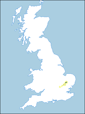
Distribution Map
 |
Note that the yellow shading represents a buffer to highlight the location of very small areas of the association.
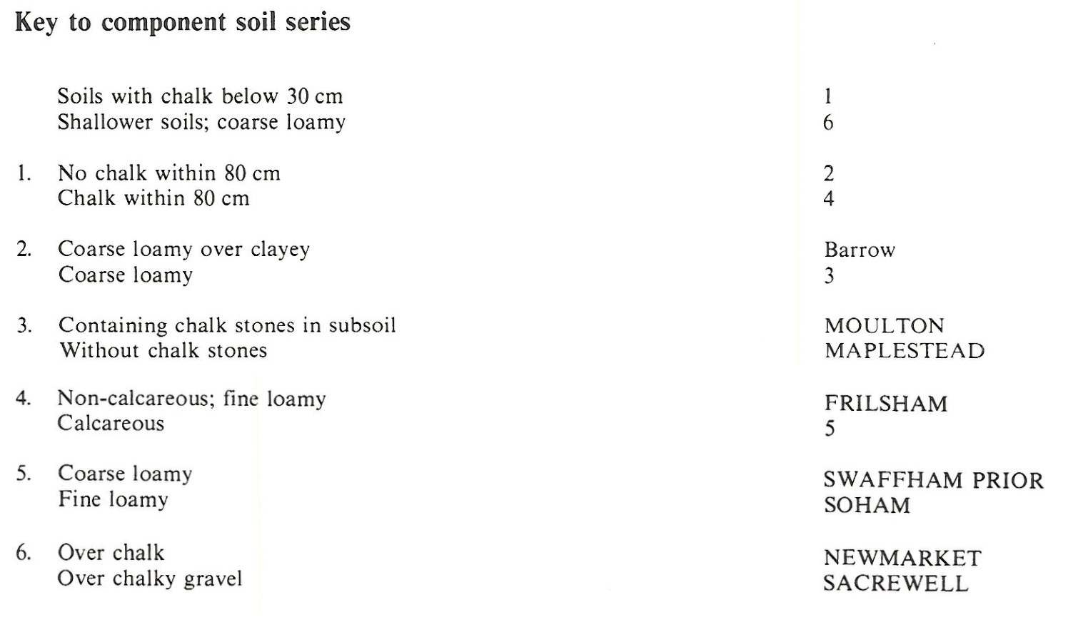
Keys to component soil series
Eastern Region
 |
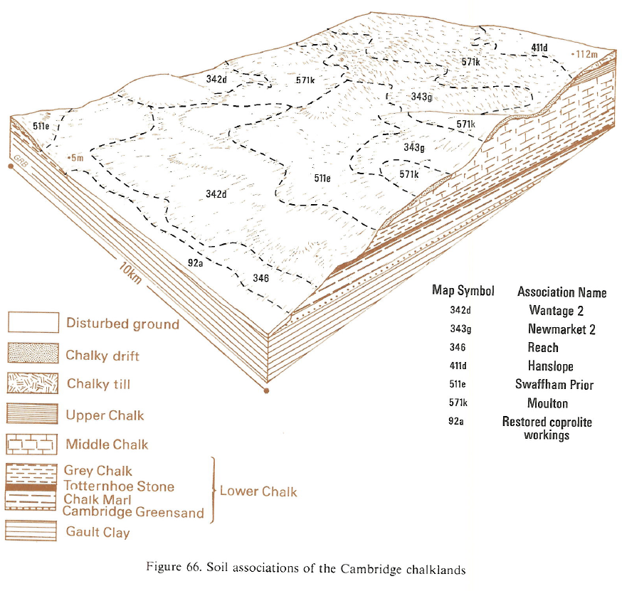
Typical Landscapes
Eastern Region
 |
All information Copyright, Cranfield University © 2024
Citation: To use information from this web resource in your work, please cite this as follows:
Cranfield University 2024. The Soils Guide. Available: www.landis.org.uk. Cranfield University, UK. Last accessed 26/04/2024
