
Interpretations of the National Soil Map of England and Wales
NATMAP HOST
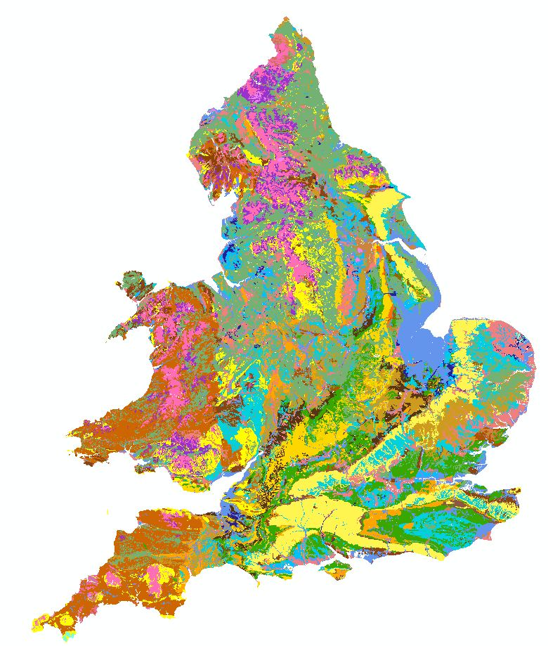
Hydrology of Soil Types (HOST) Map
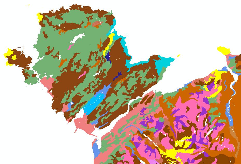
NATMAP HOST is a new product derived from the National Soil Map. It provides users with a useful, concise, easily interpreted and applicable description of the range of soil hydrological responses typical across England and Wales.
Key Facts and Statistics about NATMAP HOST
- Simplified rendition of the national soil map;
- 29 distinct classes
- The HOST Classification was defined jointly by NSRI, CEH and The James Hutton Institute
- Details of the model are published in Hydrology of Soil Types: a hydrologically-based classification of the soils of the United Kingdom - IH Report 126
Who and what is this useful for?
NATMAP host is useful for anyone wanting generalised and simple-to-understand information on soil hydrological properties at a 1:250,000 scale.
How was this map derived?
A hydrologically-based classification of the soils of the United Kingdom that describes both the soils and their distribution, and the hydrological response of catchments. The classification is based on conceptual models of the processes that occur in the soil and, where appropriate, the substrate. The resulting scheme has 29 classes, based on eleven response models; Soils are assigned to classes on the basis of their physical properties, and with reference to the hydrogeology of the substrate.
For this map the host classes of each of the component soil series in a soil association was derived and the percentage of each host class was calculated within each polygon. The dominant host classification was also identified.
How much does this product cost?
- £250 per 1,000 km2.
- Significant discounts apply for larger areas.
For detailed pricing information, use our Quotation Advisor utility.
NATMAP Host data and description
The table below describes the various properties within this data product. Each polygon contains the information outlined below.
| Property | Example from data | Description |
|---|---|---|
| HOST | 24 | The dominant HOST Class in the polygon |
| HOST1 | 0 | Percentage of the polygon in HOST Class 1 Free draining permeable soils on chalk and chalky substrates with relatively high permeability and moderate storage capacity. |
| HOST2 | 0 | Percentage of the polygon in HOST Class 2 Free draining permeable soils on 'brashy' or dolomitic limestone substrates with high permeability and moderate storage capacity. |
| HOST3 | 0 | Percentage of the polygon in HOST Class 3 Free draining permeable soils on soft sandstone substrates with relatively high permeability and high storage capacity. |
| HOST4 | 0 | Percentage of the polygon in HOST Class 4 Free draining permeable soils on hard but fissured rocks with high permeability but low to moderate storage capacity. |
| HOST5 | 0 | Percentage of the polygon in HOST Class 5 Free draining permeable soils in unconsolidated sands or gravels with relatively high permeability and high storage capacity. |
| HOST6 | 0 | Percentage of the polygon in HOST Class 6 Free draining permeable soils in unconsolidated loams or clays with low permeability and storage capacity. |
| HOST7 | 0 | Percentage of the polygon in HOST Class 7 Free draining permeable soils in unconsolidated sands or gravels with groundwater at less than 2m from the surface. |
| HOST8 | 0 | Percentage of the polygon in HOST Class 8 Free draining permeable soils in unconsolidated loams or clays with groundwater at less than 2m from the surface. |
| HOST9 | 0 | Percentage of the polygon in HOST Class 9 Soils seasonally waterlogged by fluctuating groundwater and with relatively slow lateral saturated conductivity. |
| HOST10 | 0 | Percentage of the polygon in HOST Class 10 Soils seasonally waterlogged by fluctuating groundwater and with relatively rapid lateral saturated conductivity. |
| HOST11 | 0 | Percentage of the polygon in HOST Class 11 Drained lowland peaty soils with groundwater controlled by pumping. |
| HOST12 | 0 | Percentage of the polygon in HOST Class 12 Undrained lowland peaty soils waterlogged by groundwater. |
| HOST13 | 0 | Percentage of the polygon in HOST Class 13 Soils with slight seasonal waterlogging from transient perched water tables caused by slowly permeable subsoil or substrate layers. |
| HOST14 | 0 | Percentage of the polygon in HOST Class 14 Soils seasonally waterlogged by perched water tables caused by impermeable subsoil or substrate layers. |
| HOST15 | 0 | Percentage of the polygon in HOST Class 15 Permanently wet, peaty topped upland soils over relatively free draining permeable rocks. |
| HOST16 | 0 | Percentage of the polygon in HOST Class 16 Relatively free draining soils with a moderate storage capacity over slowly permeable substrates with negligible storage capacity. |
| HOST17 | 10 | Percentage of the polygon in HOST Class 17 Relatively free draining soils with a large storage capacity over hard impermeable rocks with no storage capacity. |
| HOST18 | 10 | Percentage of the polygon in HOST Class 18 Slowly permeable soils with slight seasonal waterlogging and moderate storage capacity over slowly permeable substrates with negligible storage. |
| HOST19 | 0 | Percentage of the polygon in HOST Class 19 Relatively free draining soils with a moderate storage capacity over hard impermeable rocks with no storage capacity. |
| HOST20 | 0 | Percentage of the polygon in HOST Class 20 Slowly permeable soils with slight seasonal waterlogging and moderate storage capacity over impermeable clay substrates with no storage capacity. |
| HOST21 | 0 | Percentage of the polygon in HOST Class 21 Slowly permeable soils with slight seasonal waterlogging and low storage capacity over slowly permeable substrates with negligible storage capacity. |
| HOST22 | 0 | Percentage of the polygon in HOST Class 22 Relatively free draining soils with low storage capacity over hard impermeable rocks with no storage capacity. |
| HOST23 | 0 | Percentage of the polygon in HOST Class 23 Slowly permeable soils with slight seasonal waterlogging and low storage capacity over impermeable clay substrates with no storage capacity. |
| HOST24 | 65 | Percentage of the polygon in HOST Class 24 Slowly permeable, seasonally waterlogged soils over slowly permeable substrates with negligible storage capacity. |
| HOST25 | 0 | Percentage of the polygon in HOST Class 25 Slowly permeable, seasonally waterlogged soils over impermeable clay substrates with no storage capacity. |
| HOST26 | 0 | Percentage of the polygon in HOST Class 26 Permanently wet, peaty topped upland soils over slowly permeable substrates with negligible storage capacity. |
| HOST27 | 0 | Percentage of the polygon in HOST Class 27 Permanently wet, peaty topped upland soils over hard impermeable rocks with no storage capacity. |
| HOST28 | 0 | Percentage of the polygon in HOST Class 28 This soils type, eroded peat, is not mapped separately in England and Wales. |
| HOST29 | 0 | Percentage of the polygon in HOST Class 29 Permanently wet upland blanket peat. |
| SHAPE | 2 | Feature ID code which links with the spatial description of the data within a geodatabase |
