Auger Bores
Auger Bore Information
Soil Data surveyed by Auger Bore
To purchase Auger bore site and horizon data for your area please visit the Cranfield Mapshop
The Soil Survey of England and Wales surveyed many sites during its active years between 1939 and 1987. Much of the legacy of this work can be found electronically in LandIS and also in the original records, publications and maps in the soil survey archive at Cranfield University.
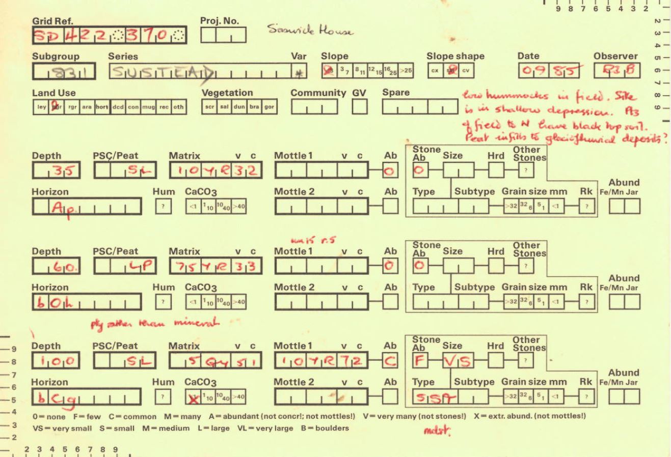
During the National Soil mapping programme a large number of auger borings were taken and a standardised form was devised to capture this information. The field description cards (Ragg User Friendly Forms, or RUFFs) were designed to cater for semi-detailed, detailed and ad hoc surveys.
The RUFF form was updated after the National Map programme and subsequent mapping was carried out using the new form. The ID number of the records indicates which card was used (A1 or A2 respectively).
LandIS contains more than 150,000 auger bores (representing >450,000 horizons) made during various mapping projects.
Instructions for filling in the Auger cards (known as 'RUFFS' cards) are available online here
The information derived from the auger bores was used by soil surveyors in the field to validate their conceptual model of how the soils varied in the landscape during the various mapping projects.
Auger Bore Site Data
| Attributes | Description |
| AUGERID | Identification code created to uniquely identify auger bores: Ax-SQen/eeennn-yy where x = 1 for auger bores collected as part of the National Map and x=2 for auger bores collected on the revised form. 'yy' is a number added to uniquely identify auger bores collected within 10m of each other |
| EASTING | National Grid reference easting (metres) |
| NORTHING | National Grid reference northing (metres) |
| SURVEY_DAT | Date of auger bore was sampled |
| SERIES_NAME | The name of the soil series, the basic unit of soil taxonomic classification, named after the place where they were first described |
| VARIANT | Code to indicate that the profile is a variation of the defined soil series classification |
| SUBGROUP | Number used to define a subgroup incorporating the major group, group and subgroup i.e.3.11, being the third level of soil taxonomic classification based on features which further define the inherent characteristics of the soil material |
| LANDUSE | Classification of Land use in to 17 classes |
| SLOPE | Slope in degrees |
| SLOPE_FORM | Slope form along the direction of the true slope (concave, straight or convex) |
| EROSION | Classification of surface features formed by erosion of soil material |
| DEPOSITION | Classification of surface features formed by the accumulation of soil material |
| ROCKTYPE | Classification of rock based on recent Geological Survey and other modern publications |
Auger Bore Horizon Data
| Attributes | Description |
| AUGERID | Identification code created to uniquely identify auger bores: Ax-SQen/eeennn-yy where x = 1 for auger bores collected as part of the National Map and x=2 for auger bores collected on the revised form. 'yy' is a number added to uniquely identify auger bores collected within 10m of each other |
| EASTING | National Grid reference easting |
| NORTHING | National Grid reference northing |
| UPPER_DEPT | Horizon upper depth in cm (<0 indicated litter layer) |
| LOWER_DEPT | Horizon lower depth in cm (999 implies depth below bottom of profile) |
| TEXTURE | Horizon Designation - At a basic level A (Topsoil) B (subsoil) C (Parent Material) E (Elluvial) O (Organic) |
| VON_POST | Modified version of the Von Post scale for assessing the degree of decomposition of peat |
| MATRIX_COL | Colour of soil matrix following the Munsell colour notation |
| MOTTLE_ABU | Abundance code for mottles ranging from none to very many |
| MOTTLE_COL | Colour of mottles following the Munsell colour notation |
| SUB_MOTTLE | Abundance code for subsidiary mottles ranging from none to very many |
| SUB_MOTT_1 | Colour of subsidiary mottles following the Munsell colour notation |
| STONE_ABUN | Abundance code for stones |
| STONE_SIZE | Size classification for stones |
| STONE_TYPE | Classification of stone based on recent Geological Survey and other modern publications |
| CARBONATE | Calcium Carbonate level of soil estimated in the field by observing when a few drops of 10 per cent hydrochloric acid are applied |
| TOP_BOTTOM | Indicator of whether an horizon is either the Top (T) or Bottom (B) horizon |
