National Soils Inventory - NSI
NSI Features

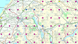
The National Soil Inventory (NSI) features data is a spatial, point dataset with 6,127 points, located in a 5km grid across England and Wales.
NSI features derives many parameters beneficial for modelling soils. These parameters, derived from readings and measurements taken at the NSI site include the depth from the surface to various layers, as well as providing information on the amount of risk that is posed to this soil by erosion and flooding. This dataset will prove important for those wanting a good understanding of the depths of the various layers in the soil profile, and those interested in mapping risks.
NSI features was used in the creation of the DEFRA Agricultural Land Classification (ALC).
How much does this product cost?
- £1000 for each individual property across England and Wales;
- £24 per point, all data for that point (discounted for more than 50 points);
- £9,550 for the whole dataset.
For detailed pricing information, use our Quotation Advisor utility.
NSI Site data and description
The table below describes the various properties within this data product. Each point contains the information outlined below.
| Property | Example from data | Description |
|---|---|---|
| EAST_NSI | 91000 | National Grid reference easting at 5km x 5km resolution with 1km offset from true grid |
| NORTH_NSI | 11000 | National Grid reference northing at 5km x 5km resolution with 1km offset from true grid |
| DTOP | Depth (cm) of topsoil | |
| DGLEY | Depth to gleyed horizon (cm). A value of '999' implies there was NO gleyed horizon present. | |
| DSGLEY | Depth to slightly gleyed horizon (cm). A value of '999' implies there was NO slightly gleyed horizon | |
| DSKL | Depth (cm) to skeletal horizon. A value of '999' implies there was NO skeletal horizon | |
| DROCK | Depth (cm) to rock. A value of '999' implies there was NO rock | |
| DSPL | Depth (cm) to slowly permeable layer, i.e. in which effectively there is no downward percolation of water. A value of '999' implies there was NO slowly permeable layer | |
| CALCAREOUS_TOPSOIL | Yes / No, indicating if the topsoil is calcareous or not (where Y= Greater than 1% CaCO3) | |
| ORGANIC_TOPSOIL | Indicates Carbon >12% in the top 25cm | |
| DISTURBED | Soil disturbed indicator (Y/N) | |
| EROSION_RISK | Indication of the erosion risk: Y (erosion risk), N (no risk), I (indeterminate) | |
| FLOOD_RISK | Susceptibility to flooding indicator Y/N | |
| MARINE_ALLUVIUM | Marine alluvium indication: possible (Y), not possible (N) or could be possible (M) |
