
Soil Associations
1013b CROWDY 2
Soil and site characteristics
Thick very acid amorphous raw peat soils. Perennially wet. Hagged and eroded in places.
Geology
Blanket and basin peat
Cropping and Land Use
Wet moorland and wetland habitats of poor and moderate grazing value; military use.
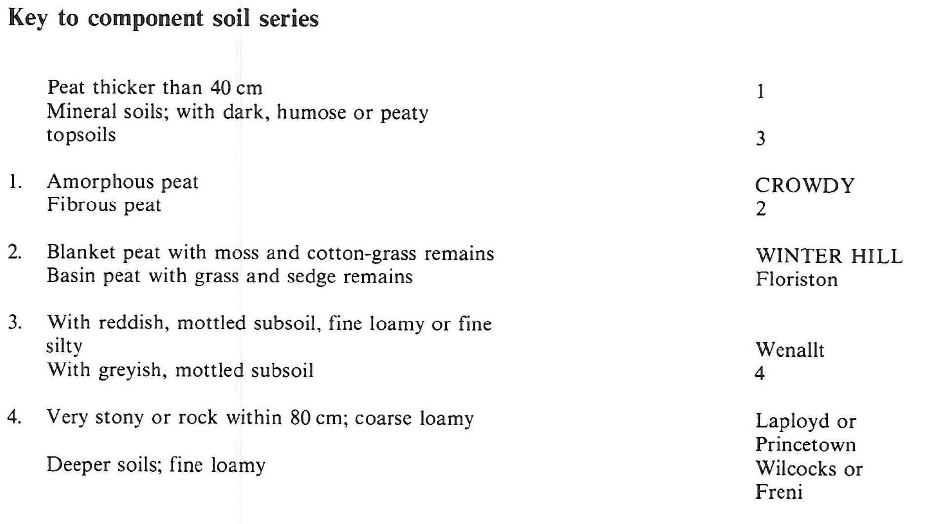
Component soil series
| Subgroup | Series name | Percentage | WRB 2006 link |
|---|---|---|---|
| 10.13 | CROWDY | 50% | Ombric Sapric Histosols |
| 10.11 | WINTER HILL | 35% | Ombric Fibric Histosols |
Covers 609 km2 in England and Wales
Soilscapes Classification
| 25 |
Blanket bog peat soils |
1013b CROWDY 2
Detailed Description
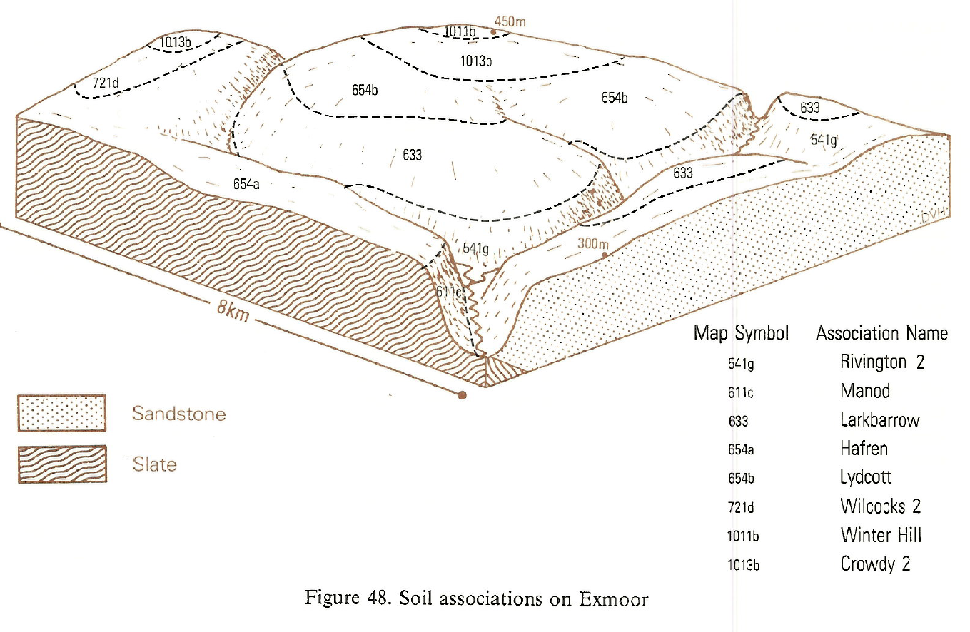
Raw acid peat soils dominate this association which occupies wide upland tracts of blanket bog and scattered peat-filled basins in Wales and South West England. A small area on the Black Mountains extends into Herefordshire. Well humified peats of the Crowdy series are most extensive while the chief associate is the more fibrous Winter Hill series with visible Eriophorum-Sphagnum remains. Altitudes range from sea-level in west Wales to more than 600 m in the east. The famous lowland raised bogs at Borth and Tregaron are included. These have floristic and pedological affinities with blanket bogs, the peat having both amorphous and semi-fibrous layers unlike the dominantly fibrous peats of raised bogs elsewhere. The association also includes some grass-sedge peats of the Floriston series in valley bottoms. Shallower soils, either peaty topped or mineral, are rare.
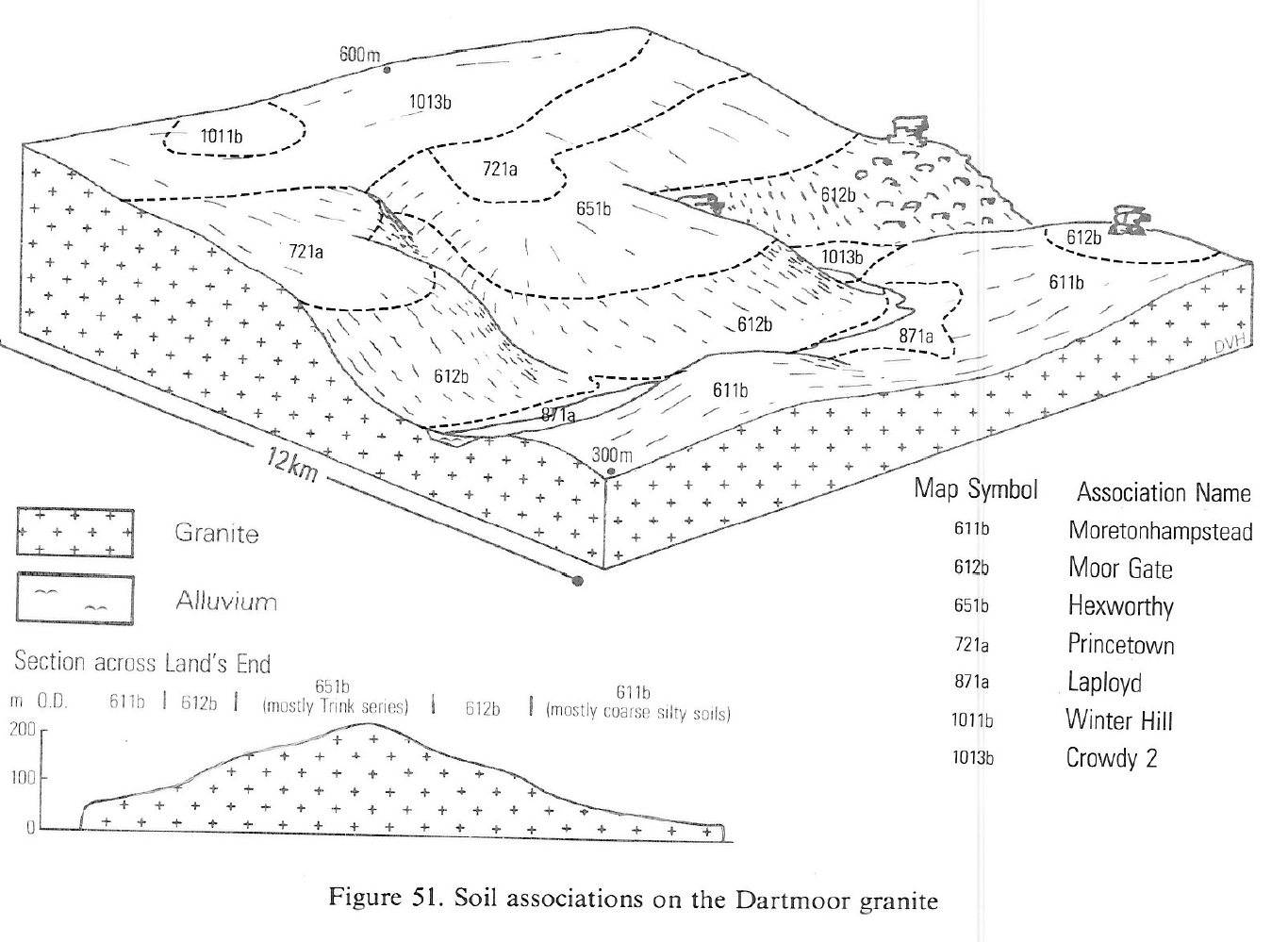
The association is extensive on the blanket bogs of Dartmoor, with smaller patches on Exmoor and in the valley bogs of Bodmin Moor. On Dartmoor, Princetown soils occur where the peat thins on moderate slopes or where surface peat has been removed by cutting or erosion. Fibrous peat soils of the Winter Hill series occupy perennially waterlogged hillside flushes and basins where peat is often still growing. Humic gley soils, Laployd series occur along streams and near the margins of flushes and basins.
Soil Water Regime
The soils are more or less permanently wet (Wetness Class VI) and this usually prevents their economic improvement. The watersheds are important gathering grounds for reservoirs as at Lake Vyrnwy. The available water capacity of peat soils is about twice that of mineral soils (Rudeforth and Thomasson 1970) and the peats store large amounts of water which is released slowly into the reservoirs, sustaining flow in dry periods. During protracted dry spells the peat contracts so that heavy subsequent rains pass rapidly through cracks to the streams and rivers and locally form dendritic erosion channels in the peat itself. In winter when the peat has swollen and the cracks have closed, excess rainwater flows rapidly from the saturated surface.
The climate of the blanket bogs on Dartmoor and Exmoor is severe above 400 m O.D. where the average annual rainfall is about 2,000 mm. The basin peats are mainly on Bodmin Moor below 300 m O.D. and kept wet by high groundwater. Much of the winter rain runs rapidly to the streams.
Cropping and Land Use
The climate of the blanket peat land is cold, wet and exposed. Average annual rainfall is typically around 2000mm. Relative humidity remains high throughout the year, with the prevailing moist winds from the south-west or west moderating the severity of the winter. Winter snowfalls are usual and often deep. By contrast the climate of the lowland bogs such as those at Borth and Tregaron is warmer, drier and more oceanic (Bendelow and Hartnup 1980). The climate and soil wetness restrict land use to poor grazing, mainly by sheep, and most of the land remains unenclosed and carries a semi-natural vegetation. The nutrient status of the soils is very poor. The vegetation is blanket bog dominated by cotton-grasses or purple moor-grass, the latter being more common in basins where the nutrient status is higher. Bog heather moor occurs locally, particularly on the lowland bogs. Valley bogs usually contain more nutrients and this encourages tree growth to form acid carr vegetation with willows and alders. The semi-natural vegetation communities of the rough grazings provide valuable refuges for wildlife. In particular heather moorland is now relatively rare and the ecosystems of the National Nature Reserves on Borth and Tregaron bogs are considered by conservationists to be of international importance for their assemblages of plants and animals, and for the evidence of past environments which is available in the form of pollen and other plant remains in the peat. Recreational use is limited because it is difficult to walk or ride over the soft wet land with its uneven sometimes thick heathery vegetation, though the areas provide a retreat for those seeking solitude in a relatively natural environment, and the Offa's Dyke path crosses the association on the English border near Hay Bluff. Some moors are traditionally used for grouse shooting, but this is much less common than on similar ground in Northern England and Scotland.
Though the blanket bogs support only limited wildlife they contribute much to the upland scenery of Dartmoor and Exmoor. The valley bogs provide contrast and variety in flora and fauna with adjacent heather moors and grasslands or, at lower altitude, with enclosed farmland. Much of the land has been set aside for conservation, notably on northern Dartmoor (Ratcliffe 1977) and on central Exmoor where it forms part of the area recommended by Porchester (1977) to remain permanently in moorland. The blanket bogs of Dartmoor and Exmoor are important regulators of run-off despite large areas of erosion, notably on northern Dartmoor. Summer and autumn rainfall are stored and slowly released at the headwaters of many rivers, some of which, on Dartmoor, have been dammed for reservoirs. On Bodmin Moor several of the valley bogs have been flooded for the same purpose.
1013b CROWDY 2
Distribution Map
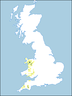 |
Note that the yellow shading represents a buffer to highlight the location of very small areas of the association.
Keys to component soil series
South Western Region
 |
Wales
 |
Typical Landscapes
South Western Region
 |
South Western Region
 |
Wales
Wales
 |
Wales
 |
All information Copyright, Cranfield University © 2025
Citation: To use information from this web resource in your work, please cite this as follows:
Cranfield University 2025. The Soils Guide. Available: www.landis.org.uk. Cranfield University, UK. Last accessed 25/04/2025
