
Soil Associations
1024b ADVENTURERS' 2
Soil and site characteristics
Deep peat soils over variable subsoils, usually sandy sometimes gravelly. Sandy soils with a peaty or humose surface horizon. Complex soil patterns locally. Flat land. Groundwater levels controlled by ditches and pumps. Risk of wind erosion.
Geology
Fen peat over glaciofluvial drift Tertiary and Cretaceous sand
Cropping and Land Use
Cereals, potatoes, sugar beet and field vegetables in the Fens; grassland in Surrey.
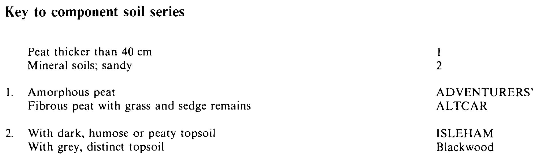
Component soil series
| Subgroup | Series name | Percentage | WRB 2006 link |
|---|---|---|---|
| 10.24 | ADVENTURERS' | 60% | Drainic Rheic Sapric Histosols |
| 8.61 | ISLEHAM | 20% | Arenic Mollic Gleysols |
| 10.22 | ALTCAR | 20% | Drainic Rheic Fibric Histosols |
Covers 113 km2 in England and Wales
Soilscapes Classification
| 27 |
Fen peat soils |
1024b ADVENTURERS' 2
Detailed Description
Amorphous and semi-fibrous lowland peat soils, together with some sandy soils with peaty topsoils, form this association. It is widely distributed and covers 112 km² nationally, mainly in the Fens of Eastern England-along their eastern margin from near Soham in Cambridgeshire to King's Lynn in Norfolk, and at their western edge near Bourne, Lincolnshire, and east of Lincoln. Elsewhere the association is found in valleys, often at the wider parts where streams converge. There are small areas near Norwich and at Gainsborough in Lincolnshire and in the undulating glaciated landscape of Cheshire and Shropshire near Warrington, Whitchurch and Wem. The association also occurs around Chobham in Surrey and near Fleet in Hampshire.
The Adventurers' series, earthy eutro-amorphous peat soils, is generally dominant, covering half to three-quarters of most parcels of land. It is commonly associated with the less humified Altcar series, earthy eu-fibrous peat soils, which in some areas, principally in Lincolnshire, is dominant. Both Adventurers' and Altcar series are formed in fen and carr peat. In Eastern England and the Midlands, glaciofluvial sands in part underlie the peat and where this has wasted, Isleham series, typical humic sandy gley soils, and less commonly the non-humose but sandy Blackwood series occur. In South East England, the underlying sands are mainly derived from the Bagshot Beds but the soils also overlie river terrace deposits.
As the Fens are at or a little below sea level the association occurs mostly within internal drainage districts where the water level is closely controlled by means of ditches and pumps, and, being now largely well-drained, the land is mainly arable. Most parcels elsewhere are grassland, drained, often ineffectively, by gravity. Patterned hummocky ground is found where the Fens adjoin the Breckland.
In Lincolnshire the peat mainly overlies river terrace sands, but near Bourne, marine clays and silts are common below the peat and Downholland soils are included on the seaward side of the association. Near Downham Market in Norfolk, the peat rests locally on clays giving Duckpit soils. Brimpton series is found on the sites of former small pools, now marked by thin beds of shell marl. These pools or meres were most common near Hockwold and Lakenheath where shell marl bands, brought to the surface through wastage, have sometimes been ploughed in giving calcareous topsoils to both the Adventurers' and Isleham series. The land here has a hummock and hollow micro-relief in which peat-filled hollows with Adventurers' series alternate with ridges or knolls of sand a metre or so higher than the general level carrying Isleham and Blackwood series. The Chalk outcrop is close by and chalky Reach and Wilbraham series form up to a fifth of these parcels. Further south, near Soham, the strongly acid Mendham series occurs locally.
In South East England it occurs mainly in Surrey, at between 20 and 60 m O.D. in the broad basin of the Bourne around Chobham, flanking the tributary streams and also in Hampshire, north-east of Fleet.
Soil Water Regime
The soils are permeable and, apart from a few places where there is a clay subsoil, the land can be drained by ditches alone. With efficient arterial drainage as in much of the Fens, the soils are well-drained (Wetness Class I). The Adventurers' and Altcar soils are water-retentive and crops other than grass do not normally suffer from drought. Isleham soils, where well-drained, have less water available to plants. They are slightly droughty for cereals, moderately to very droughty for potatoes and very droughty for grass. Because they are not humose, Blackwood soils are correspondingly droughtier. The effect of drought is well shown by patchy crop growth on land with hummock and hollow microrelief, as groundwater is relatively lower in raised sandy soils than in the peaty hollows.
Cropping and Land Use
Where well-drained, the soils are easily worked, especially Isleham and Blackwood series which are accessible shortly after rain. There are thus few restrictions to cultivating the land and harvesting crops. These are mainly cereals, but sugar beet, potatoes and field vegetables are grown, and carrots and celery are characteristic on the peat soils. Cereals do not always finish well and sugar beet, although yielding heavily, has a low sugar content. Manganese deficiency occurs where the soils are calcareous. Wind erosion is a hazard especially in dry springs and care must be taken not to start fires as a burning peat subsoil is difficult to extinguish.
1024b ADVENTURERS' 2
Distribution Map
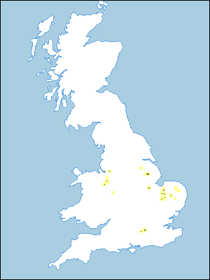 |
Note that the yellow shading represents a buffer to highlight the location of very small areas of the association.
Keys to component soil series
Eastern Region
 |
All information Copyright, Cranfield University © 2025
Citation: To use information from this web resource in your work, please cite this as follows:
Cranfield University 2025. The Soils Guide. Available: www.landis.org.uk. Cranfield University, UK. Last accessed 25/04/2025
