
Soil Associations
0372 Willingham
Soil and site characteristics
Extremely calcareous silty and clayey soils, in places humose, and often over peat. Some patches of deep peat. Flat land. Groundwater usually controlled by ditches and pumps. Risk of wind erosion.
Geology
Lake marl tufa and peat
Cropping and Land Use
Cereals, potatoes, sugar beet and other arable crops; vegetables locally.
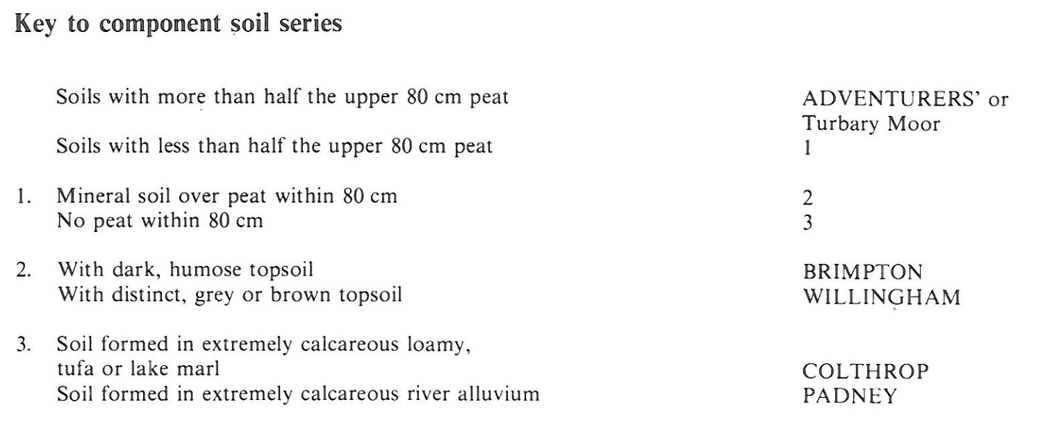
Component soil series
| Subgroup | Series name | Percentage | WRB 2006 link |
|---|---|---|---|
| 3.72 | PADNEY | 25% | Drainic Calcaric Fluvic Gelysols |
| 3.72 | WILLINGHAM | 23% | Epigleyic Rendzic Phaeozems |
| 3.73 | BRIMPTON | 22% | Thaptohistic Limnic Calcaric Mollic Gleyic Fluvisols |
| 3.72 | COLTHROP | 15% | Limnic Calcaric Gleyic Mollic Fluvisols |
| 10.24 | ADVENTURERS' | 15% | Drainic Rheic Sapric Histosols |
Covers 47 km2 in England and Wales
Soilscapes Classification
| 27 |
Fen peat soils |
0372 Willingham
Detailed Description
This association comprises mainly permeable or moderately permeable, stoneless, extremely calcareous, loamy or clayey soils formed in lake marl, tufa or peat. It occurs on the beds of former meres or pools mainly in the fens of Cambridgeshire, Norfolk and Suffolk but also locally on the wide floodplain of the River Test outside Southampton. Small areas are found in the Idle valley in Nottinghamshire and in the lower Test valley near Southampton. Although covering only 43 km² it is a distinctive association as the cultivated topsoil dries white and contrasts with dark-coloured surrounding soils that are commonly humose or peaty. The contrast is so great that the largest occurrence, the bed of Redmere in Suffolk, can be seen in satellite imagery. The main soils belong to the Willingham series, gleyic rendzina-like alluvial soils. The topsoil and upper subsoil, porous and of low bulk density, are formed in a finely divided mixture of small shells and algal marl, or tufa. The calcium carbonate content is usually greater than 60 per cent. The deep subsoil is humified peat, but the similar and commonly occurring Colthrop series, also gleyic rendzina-like alluvial soils, is in thick shell marl. Brimpton series, humic gleyic rendzina-like alluvial soils, with a darker topsoil and higher organic matter content are common especially towards the margins of the former meres. Where shell marl is mixed with alluvium, clayey but less calcareous Padney, gleyic rendzina-like alluvial soils, are found and are locally dominant. In contrast, the Adventurers' series, earthy eutro-amorphous peat soils, occurs in patches in very variable proportions in the different parcels of the association. The land is flat, ditched, and generally open and treeless but may be raised a metre or so above the general level because of wastage of the surrounding peat. Most of the land is within internal drainage districts which provide adequate flood protection and water levels are controlled by pumping so that the soils are generally well drained.
The mere deposits vary considerably. At Redmere, which covers 11 km², Willingham and Colthrop series in almost equal proportions are the most extensive soils with Brimpton series around the edges where the lake marl passes laterally into peat. There is only a small patch of Adventurers' series. Near the northern end of the Bedford Rivers, the soil distribution is very patchy, being mainly Brimpton series with subordinate Willingham series, both with thin layers of shell marl over peat interspersed with Adventurers' series. At Soham Mere, the marl deposits are more clayey and contain 40-50 per cent calcium carbonate. Overlapping the peat, they lie in part directly on a mineral substratum. Here Padney soils are dominant with subordinate Adventurers' soils. Whittlesey Mere is intermediate in character between Redmere and Soham Mere, the most common soil being the clayey Padney series but loamy Colthrop, Willingham and Brimpton series are also extensive. The peat soils included here are mainly Turbary Moor series on thin Sphagnum-Eriophorum peat. The sites of other, mostly small, meres in the Fens have a large proportion of soils with humose topsoils.
Soil Water Regime
Willingham, Colthrop and Brimpton soils with their permeable topsoils and mineral subsoils overlying humified peat at greater depth are well-drained (Wetness Class I) where there is efficient pumped drainage. Adventurers' and Turbary Moor soils are well-drained. The Padney with its larger clay content is occasionally waterlogged (Wetness Class II). The main soils, except Padney series, are water retentive and non-droughty for arable crops.
Cropping and Land Use
The soils are mostly fine silty, humose or peaty and, with water levels kept low by pumps in winter, they are easy to cultivate and there is ample time for autumn and spring landwork. Padney soils require more careful management as they become sticky when wet and compaction or capping causes surface wetness. The land is intensively farmed and cereals, cash root crops and field vegetables are grown. Manganese deficiency induced by the high calcium carbonate content of the soils is a limitation and there is a slight risk of wind erosion on the more silty soils
0372 Willingham
Distribution Map
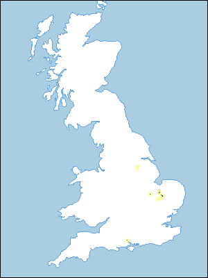 |
Note that the yellow shading represents a buffer to highlight the location of very small areas of the association.
Keys to component soil series
Eastern Region
 |
Typical Landscapes
Eastern Region
 |
All information Copyright, Cranfield University © 2025
Citation: To use information from this web resource in your work, please cite this as follows:
Cranfield University 2025. The Soils Guide. Available: www.landis.org.uk. Cranfield University, UK. Last accessed 25/04/2025
