
Soil Associations
0511f COOMBE 1
Soil and site characteristics
Well drained calcareous fine silty soils deep in valley bottoms, shallow to chalk on valley sides in places. Slight risk of water erosion
Geology
Chalky drift and chalk
Cropping and Land Use
Winter cereals, cereal and grassland rotations with dairying; some horticultural crops.
Component soil series
| Subgroup | Series name | Percentage | WRB 2006 link |
|---|---|---|---|
| 5.11 | COOMBE | 40% | Calcaric Cambisols |
| 5.11 | PANHOLES | 20% | Calcaric Endoleptic Cambisols |
| 3.43 | ANDOVER | 10% | Calcaric Leptosols |
| 5.71 | CHARITY | 10% | Chromic Luvisols |
| 5.14 | MILLINGTON | 10% | Colluvic Calcaric Cambisols |
Covers 778 km2 in England and Wales
Soilscapes Classification
| 5 |
Freely draining lime-rich loamy soils |
0511f COOMBE 1
Detailed Description
The soils of this association are developed in flinty, chalky drift in broad valleys and on the lower dipslope of the Chalk in southern England. There are small areas in dry valleys on the Yorkshire Wolds. The soils are well drained, calcareous, fine silty, and often very stony. They are often deep in the valley bottoms, but there are shallow soils on the valley sides. Soil variation is related to the thickness of drift over the chalk. In the Coombe series, typical brown calcareous earths, the subsoil merges downwards into thick, flinty chalky drift. The similar Millington series, typically found in narrow valleys, has a thicker subsoil with an abrupt contact with chalk, chalky drift or a buried soil beneath. Panholes series, typical brown calcareous earths, and Andover series, brown rendzinas, occur extensively in thin drift on valley sides. Charity series), typical argillic brown earths, occur in non-calcareous fine silty drift. In Eastern England these soils are found on the steeper-sided dipslope valleys of the Chiltern Hills near Hemel Hempstead. The dominant Coombe soils contain much aeolian silt, but on slopes chalk or chalky rubble is at shallow depth and the steepest west and south-facing slopes carry Andover and Panholes soils as well as very shallow Upton soils on chalk. Shallow, clayey Wallop soils directly on chalk are found on spurs and upper slopes. Deeper, non-calcareous flinty, Charity and stoneless silty Hamble soils are most frequent near the centres of the wider valleys. Occasional loamy Soham and Frilsham soils are found on patches of drift.
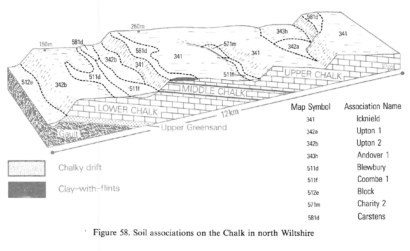
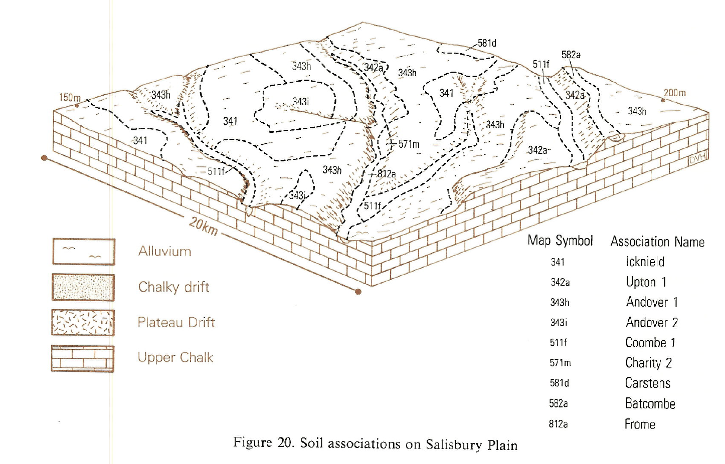
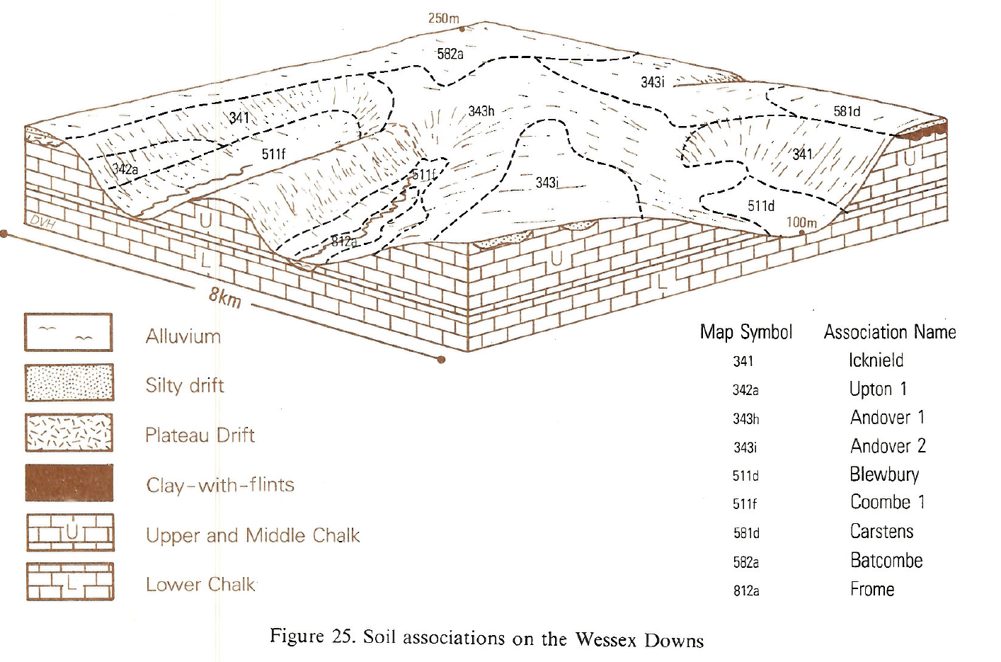
The association is found in Wiltshire in the broader valleys on the Marlborough Downs and Salisbury Plain, in dry valleys joining the Stour valley in Dorset, and locally around Beer in east Devon. Millington soils are found on the floors of narrow tributary valleys and Gore soils on footslopes in the Wylye valley, where Upton association occurs upslope. Charity soils are associates in valleys near Avebury, on the south side of the Vale of Pewsey and in the Bourne valley north of Salisbury. In east Dorset and north Wiltshire, inclusions of Frilsham and Soham soils are found on the valley floors below Tertiary and Plateau Drift deposits. Panholes soils are found on a patch of high-level drift on West Down Ranges. Wylye and Racton soils are confined to small patches of alluvium in the river valleys, like the head waters of the Avon.
Colluvial Millington soils occupy Wold valley floors. Coarse loamy Swaffham Prior soils are present where the drift contains blown sand. In the Great Wold Valley, between Weaverthorpe and Rudston, the land is undulating and Panholes and Andover soils are extensive. Adventurers' and Wylye soils are found alongside the Gypsey Race.
The association occurs in two main chalkland locations: on valley floors in Oxfordshire, Kent, Sussex, Berkshire and Hampshire; and on the gently undulating lower dipslope in east Kent, where it was mapped as the Coombe-Andover association. This broader tract has more Panholes and Andover soils than elsewhere and Charity soils occur below Clay-with-flints and Plateau Drift deposits. Frilsham, Swaffham Prior and Soham soils are found on slopes below Tertiary outcrops. Wet soils of the Wylye and Racton series are confined to narrow alluvial tracts of streams or intermittent bournes draining to the Thames.
Soil Water Regime
The soils are well drained (Wetness Class 1) and surplus winter rain passes easily downwards through the soil and the underlying chalk. Rooting depth is generally adequate and most component soils are only slightly droughty for arable crops except over harder chalk beds such as the Chalk Rock and Melbourne Rock.
Cropping and Land Use
The dominant crops are cereals and leys. Top fruit suffers from iron deficiency, but other trace element deficiencies are rare. Though otherwise sheltered, sensitive crops in valley floors are vulnerable to frost. There are ample opportunities for autumn landwork and a shorter though adequate period in spring. These soils may be compacted by badly timed cultivations but are easy to work and recover fairly easily from damage. In the South West cropping is influenced by the farming system on adjacent shallow soils. Cereals and leys are the main crops, with root crops, fruit and vegetables locally. Top fruit suffers from iron deficiency but other trace element deficiencies are rare.
Where the association is in dry valleys, cropping is influenced by the farming system on adjacent shallow soils. Cereals and grass leys are the main crops, with root crops, fruit and vegetables locally, especially in east Kent. Top fruit suffers from iron deficiency but other trace element deficiencies are rare. Valley bottoms are frost-hollows but are less exposed than many slopes.
Woodland and old grassland includes many calcicolous plant species. Larkey Valley Wood in Kent has hornbeam and hazel coppice below oak and ash standards with a ground flora dominated by bluebell (Hyacinthoides non-scripta) and dog's mercury (Mercurialis perennis). Sanicle (Sanicula europaea) and sweet woodruff (Galium odoratum) occur below beech high forest on Andover soils together with a variety of orchids, for example, the bird's-nest orchid (Neottia nidus-avis) and the lesser butterfly orchid (Platanthera bifolia).
0511f COOMBE 1
Distribution Map
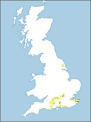 |
Note that the yellow shading represents a buffer to highlight the location of very small areas of the association.
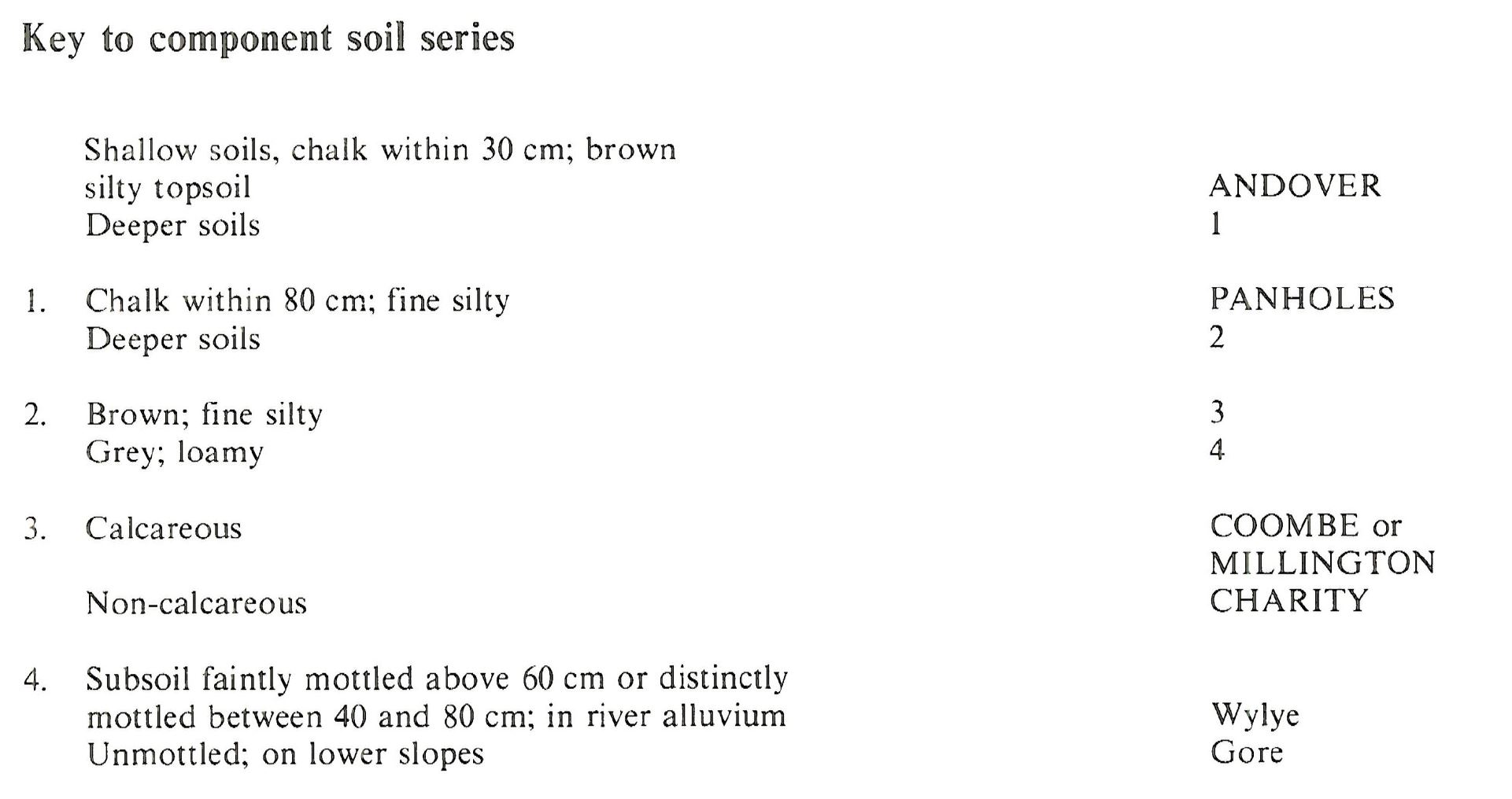
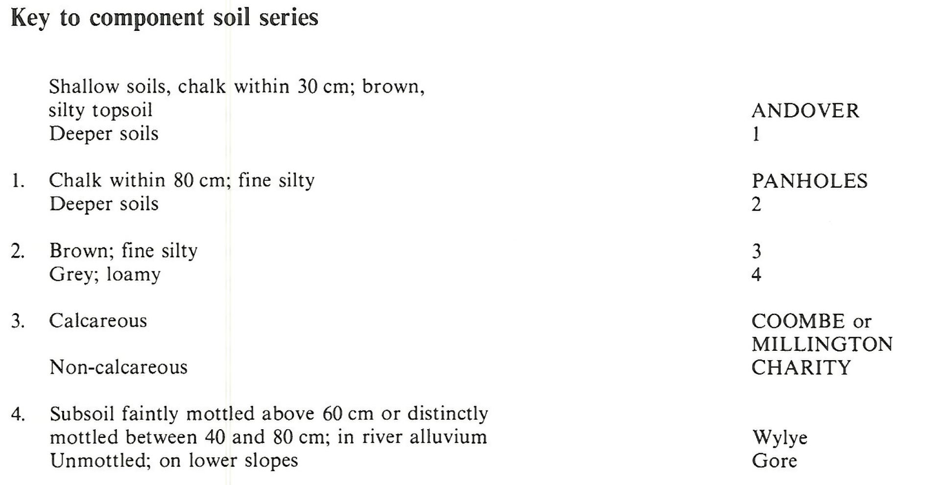
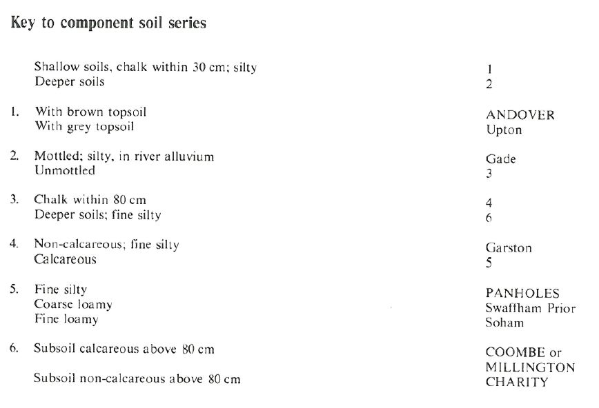
Keys to component soil series
South Eastern Region
 |
South Western Region
 |
Northern Region
 |
Typical Landscapes
South Western Region
 |
South Western Region
 |
South Western Region
 |
All information Copyright, Cranfield University © 2025
Citation: To use information from this web resource in your work, please cite this as follows:
Cranfield University 2025. The Soils Guide. Available: www.landis.org.uk. Cranfield University, UK. Last accessed 25/04/2025
