Soil Associations
0511g COOMBE 2
Soil and site characteristics
Well drained calcareous fine silty soils over chalk or chalk rubble. Shallow soils in places especially on brows and steeper slopes.
Geology
Chalky drift and chalk
Cropping and Land Use
Cereals and short term grassland with dairying; some potatoes and field vegetables.
Component soil series
| Subgroup | Series name | Percentage | WRB 2006 link |
|---|---|---|---|
| 5.11 | COOMBE | 21% | Calcaric Cambisols |
| 3.42 | WANTAGE | 19% | Rendzic Leptosols |
| 5.11 | PANHOLES | 15% | Calcaric Endoleptic Cambisols |
| 3.42 | UPTON | 10% | Rendzic Leptosols |
Covers 249 km2 in England and Wales
Soilscapes Classification
| 5 |
Freely draining lime-rich loamy soils |
0511g COOMBE 2
Detailed Description
This is the main soil association on chalky drift and chalk at the foot of the Chalk scarps of the North and South Downs of Kent, Surrey and Sussex. It also occurs along the Chilterns between the Goring and Wendover gaps. The most characteristic soil is the Coombe series, typical brown calcareous earths, with a dark brown or yellowish brown fine silty subsoil merging into variably flinty chalky drift. The similar Panholes series in thinner drift is a constant associate occurring where hard chalk is encountered within moderate depth. Shallow or very shallow extremely calcareous Wantage and Upton soils, grey rendzinas, occur where the Chalk is drift free. Small amounts of Charity, Frilsham and Soham soils are also present, and Gore and Millington soils in colluvium are frequent but minor inclusions.
The gently or moderately sloping footslopes of the escarpment form a largely drift-covered bench up to 2 km wide. It stretches from Folkestone to Guildford on the North Downs, and from Eastbourne to Petersfield at the foot of the South Downs, with interruptions at major river valleys. Coombe soils are mostly on the lower gentle slopes with Charity soils on level facets and Gore soils near the scarp. Frilsham and Soham soils occur where there is a source of loamy material in drift deposits upslope. Panholes and Wantage soils are found on steeper scarp footslopes. More rarely, Upton soils are present on harder beds near the top of the Lower Chalk. East of Guildford, seasonally waterlogged loamy Block soils and clayey Evesham soils are included where chalky drift spreads over the narrow Gault outcrop. Similar soils with humose tops are particularly common around springs. The somewhat broader spreads of the association at the foot of the Chilterns scarp have a similar composition to those at the foot of the Downs.
Soil Water Regime
The main soils of the association are permeable and well drained (Wetness Class I). Surplus winter rain passes easily downwards through the soil and the chalk below. There are large reserves of soil available water in deep Coombe soils and moderate amounts in Upton, Wantage and Panholes soils. Exploitation of this water is very dependent, however, on the compactness of the chalky drift or on the degree of shattering of underlying chalk and its effects on rooting depth. Coombe and Wantage soils are non-droughty for cereals, but Panholes and Upton soils can be slightly droughty. In most places soils are slightly droughty for potatoes and moderately droughty for grass.
Cropping and Land Use
All the soils are easy to work. Below the North Downs and the Chilterns, where return to field capacity is towards the end of November, there are long periods in autumn and spring when the soils can be cultivated safely. But return to field capacity is almost a month earlier below the South Downs, and landwork opportunities are curtailed in both autumn and spring. Intensive use of grassland is possible as there is very little risk of poaching but in drier districts there is moderate summer drought and limited autumn growth. On the South Downs, west of Brighton, grass grows well in most autumns and the potential yields of grass are large. The main crops grown are cereals and grass leys with some root crops, vegetables and maize, except on the flintiest land. There is a little soft fruit, but the large calcium carbonate content of most soils causes iron deficiency in top fruit so it cannot be grown satisfactorily.
0511g COOMBE 2
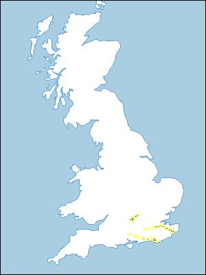
Distribution Map
 |
Note that the yellow shading represents a buffer to highlight the location of very small areas of the association.
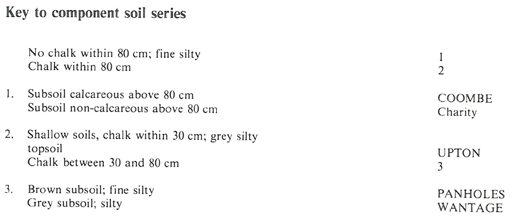
Keys to component soil series
South Eastern Region
 |
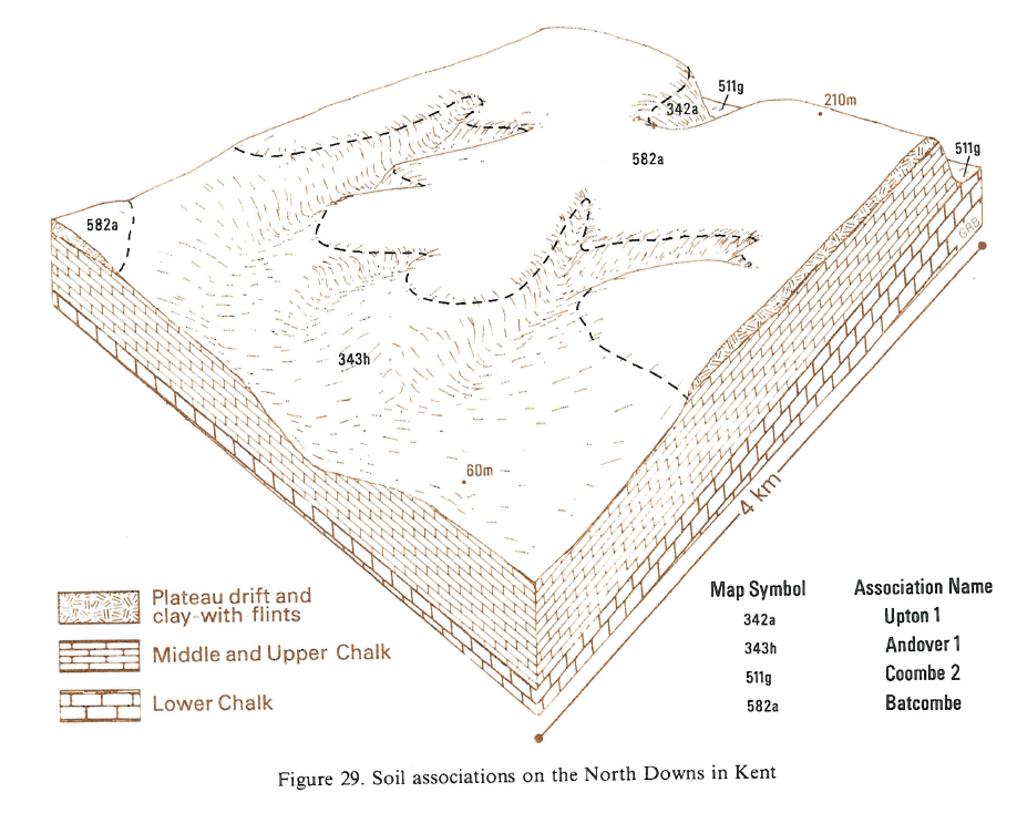
Typical Landscapes
South Eastern Region
 |
All information Copyright, Cranfield University © 2025
Citation: To use information from this web resource in your work, please cite this as follows:
Cranfield University 2025. The Soils Guide. Available: www.landis.org.uk. Cranfield University, UK. Last accessed 25/04/2025
