
Soil Associations
0511i BADSEY 2
Soil and site characteristics
Well drained calcareous fine loamy soils over limestone gravel. Some similar soils affected by groundwater.
Geology
River terrace and lacustrine gravel
Cropping and Land Use
Grassland and cereals with stock rearing in the Northern Region; cereals, sugar beet, potatoes and field vegetables in the Midlands.
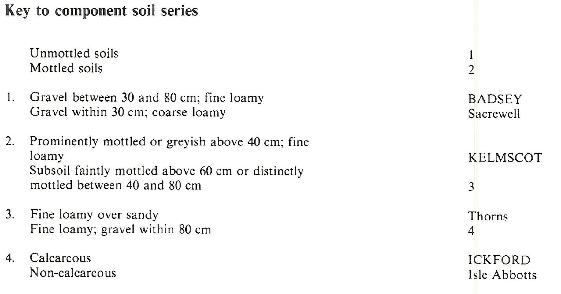
Component soil series
| Subgroup | Series name | Percentage | WRB 2006 link |
|---|---|---|---|
| 5.11 | BADSEY | 75% | Calcaric Endoskeletic Cambisols |
| 5.12 | ICKFORD | 10% | Calcaric Endogleyic Endoskeletic Cambisols |
| 8.32 | KELMSCOT | 10% | Endoskeletic Calcaric Mollic Gleysols |
Covers 233 km2 in England and Wales
Soilscapes Classification
| 5 |
Freely draining lime-rich loamy soils |
0511i BADSEY 2
Detailed Description
This association has been reported from the margins of the Cambridgeshire and Lincolnshire Fens, on the Avon and upper Thames terraces, some Yorkshire dales and the Vale of Pickering. It is composed mainly of fine loamy soils over calcareous gravel. Most soils belong to the well drained Badsey series, typical brown calcareous earths, but the occasionally waterlogged Ickford series, gleyic brown calcareous earths, and the seasonally waterlogged Kelmscot series, calcaro-cambic gley soils, reflect the influence of high groundwater levels.
In Lincolnshire and Cambridgeshire the association occurs on 97 km² of flat or gently sloping terraces in a narrow tract between Horbling and Peterborough. The terrace deposits were formed as coalescing fans of bedded gravels up to 7 m thick, deposited by rivers debouching from the limestone and clay country to the west onto lower ground. The main component soil series are all formed in relatively stone-free loamy material overlying sands and gravels in which about half the stones are limestones. Badsey series and some similar but coarse loamy soils occupy about three-quarters of the land east of Stamford where the Welland valley widens (Burton 1981). Flooding by the Welland near Maxey has added clayey alluvial material to some Badsey soils and in places low mounds carry the shallow Sacrewell series. Kelmscot and Ickford series together cover a fifth of the land, mainly beside streams, in hollows, or on the fringes of the valleys where water drains from higher ground.
As the land surface falls generally eastwards from 20 m to 3 m O.D. the proportion of more waterlogged soils increases, Ickford series to nearly a half and Kelmscot series to a fifth, but there is much local variability. Badsey soils occurs mainly on low mounds. Adjacent to the Fenland there are inclusions of Clayhythe series with humose topsoils. There are minor occurrences of Newsleaford, Ruskington and Landbeach series.
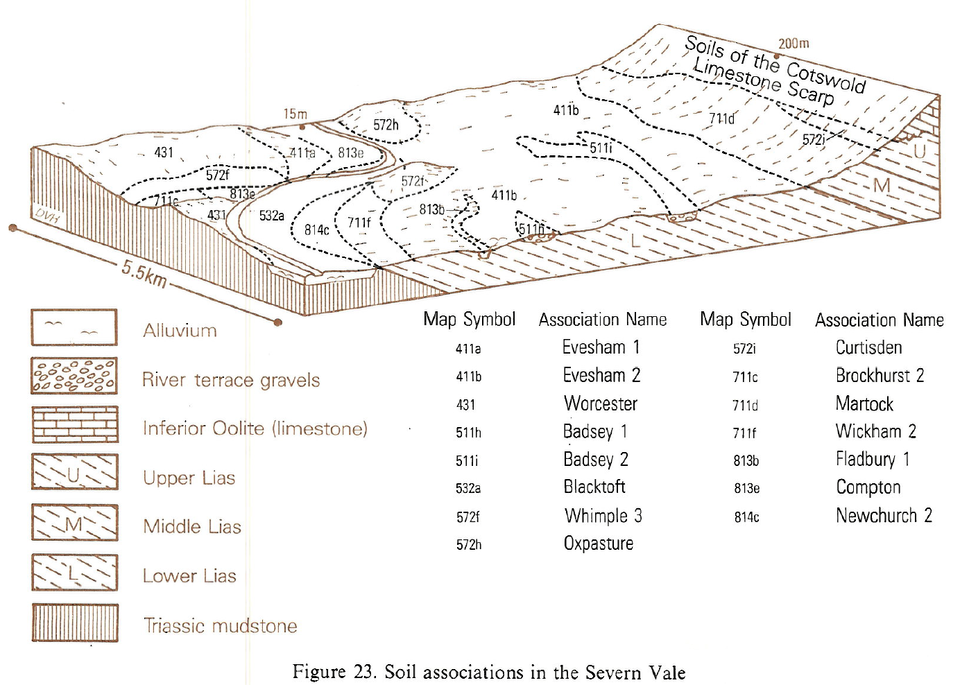
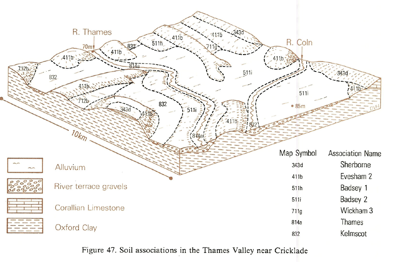
The association occurs on the lowest terraces of the river Thames between Lechlade, Marston Meysey and Pool Keynes where there are significant areas of Ickford soils and patches of Kelmscot and Thames soils. Shallow Sacrewell soils occur on higher land around South Cerney and Kempsford. Badsey soils are common on the low terraces of the Wiltshire Avon between Sutton Benger and Melksham, and on low hill tops and valley floors in the Severn Vale around Cheltenham but there are significant proportions of wetter Ickford and Isle Abbotts soils. Thorns series occurs sporadically on less gravelly deposits.
The association, which covers 39 km², is on gently or moderately sloping terraces along the rivers Wharfe and Skirfare at 200 to 275 m O.D. and on more hummocky terraces near the Ribble at Hellifield at 120 to 150 m O.D. It is also found in the Vale of Pickering at about 25 m O.D. on the gentle slopes of a former lake delta. The proportion of Ickford series varies, this being partly governed by the occasional occurrence of less gravelly Thorns series. The very shallow Sacrewell series is occasionally found, or the Carswell series, which has clayey surface horizons Non-calcareous equivalents of the chief soils are found, but soils with argillic horizons are relatively rare.
Soil Water Regime
The soils are moderately to very porous over extremely porous gravelly subsoils and are largely well drained (Wetness Class I). Winter rainwater is readily absorbed. Kelmscot soils can have some waterlogging in winter (Wetness Class II) or for longer periods in low-lying sites (Wetness Class III). Fields are drained by perimeter ditches which are linked to an arterial system which transports water to the Wash. Where there is suitable groundwater control, Ickford and Thorns (Clayden and Hollis 1984) series are well-drained, with profile gleying a relic feature. With rooting depth restricted to the loamy part above the gravels, the available water capacity of the component soils is only about 100 mm, though in places this is supplemented by groundwater. Some Kelmscot soils have carbonate-cemented pans in the zone of groundwater fluctuation which restrict rooting. The soils are moderately droughty for most crops but very droughty for grass. On some farms large pits have been excavated from which groundwater is pumped to irrigate root crops.
Cropping and Land Use
The soils are easy to cultivate with adequate days for spring and autumn cultivation in most years. They are mainly under arable cultivation for cereals, with sugar beet and potatoes. . In the Upper Thames valley around Pool Keynes large areas of flooded gravel workings are used for recreation as part of the Cotswold Water Park. The soils are easy working but cultivations need to be carefully timed when working early or late in the year to avoid compaction. Because of the relative dryness underfoot, there is little risk of poaching except alongside the main river floodplain. In the Yorkshire Dales, the association is almost entirely in permanent grass and forms some of the best land in the district. Droughtiness can be a limitation in the drier Vale of Pickering, where a wide variety of farm and horticultural crops are produced.
0511i BADSEY 2
Distribution Map
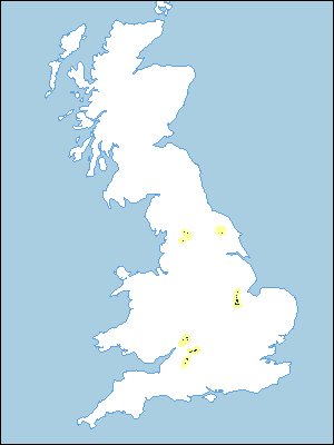 |
Note that the yellow shading represents a buffer to highlight the location of very small areas of the association.
Keys to component soil series
South Western Region
 |
Eastern Region
 |
Typical Landscapes
South Western Region
 |
South Western Region
 |
All information Copyright, Cranfield University © 2025
Citation: To use information from this web resource in your work, please cite this as follows:
Cranfield University 2025. The Soils Guide. Available: www.landis.org.uk. Cranfield University, UK. Last accessed 25/04/2025
