Soil Associations
0512e BLOCK
Soil and site characteristics
Moderately permeable calcareous loamy soils over chalky gravel variably affected by groundwater.
Geology
Chalky drift
Cropping and Land Use
Cereals, some dairying on short term and permanent grassland.
Component soil series
| Subgroup | Series name | Percentage | WRB 2006 link |
|---|---|---|---|
| 5.12 | BLOCK | 26% | Calcaric Endogleyic Cambisols |
| 5.12 | ICKFORD | 25% | Calcaric Endogleyic Endoskeletic Cambisols |
| 3.45 | FORD END | 24% | Calcaric Gleysols |
| 3.45 | BURWELL | 10% | Calcaric Gleyic Endoleptic Regosols |
Covers 104 km2 in England and Wales
Soilscapes Classification
| 5 |
Freely draining lime-rich loamy soils |
0512e BLOCK
Detailed Description
This association consists of permeable calcareous soils developed in chalky and gravelly Head and colluvium which are seasonally affected by groundwater. It is located chiefly on level or slightly sloping land below the chalk scarps of the Chiltern Hills and the Berkshire and Marlborough Downs. The Head and colluvium is derived from nearby chalk slopes and valleys and thickly mantles Lower Chalk, Upper Greensand and Gault Clay at the foot of the chalk escarpment. Most of the land is low-lying and crossed by streams rising from scarp-foot springs, but in places the soils occur on a scarp-foot bench. Block soils, gleyic brown calcareous earths, are usually dominant. They are fine loamy and calcareous with brownish subsurface horizons and have distinct greyish and ochreous mottling in the subsoil. The associated loamy Ford End and Burwell soils are extremely calcareous gleyic rendzinas. Ickford soils, also gleyic brown calcareous earths, are commonly associated with Block soils.
The association is mapped in Bedfordshire in the Vale of Aylesbury between Edlesborough and Houghton Regis. Some of the land now identified as Block association was mapped by King (1969) with the then Burwell association. In front of the Chilterns escarpment, Block and Burwell soils occur on high land, the latter series passing to soft chalk. Ford End soils are restricted to thick drift in narrow strips near springs and streams. West of Houghton Regis, Burwell soils are dominant on lower ground. Block series is common on steeper slopes and Ickford soils are found where there are gravel lenses composed of flints and chalk rubble in the subsoil. Well-drained Coombe soils are present locally and there are some Wantage soils on ridge crests.
The association extends westwards from the Vale of the White Horse to Swindon and Devizes and occurs again near Pewsey and Westbury at the foot of the Marlborough Downs. Block soils predominate with subordinate Burwell soils near the escarpment and Ford End soils on the lowest land near streams. Ickford soils are present locally and have a gravelly subsoil of soft chalk stones with occasional flint and Upper Greensand sandstone.
The soil distribution is different in the Vale of the White Horse which was mapped in detail by Jarvis (1973). Here the Block association consists mainly of soils distinguished by Jarvis as the Ford End series. The soils are mostly in thick chalky drift and on low ground extending some distance across the vale from the Chalk scarp. Ford End soils predominate, with Block and similar silty soils subordinate and on the highest land. Ickford and Gubblecote soils, with gravelly subsoils containing flint and malmstone, are locally common, as are the grey siliceous Grove soils in loamy drift over calcareous gravel. Burwell soils are rare. Fine loamy over clayey Wickham soils and calcareous St Lawrence soils occur locally.
In Kent, Ford End soils predominate and the associated Burwell soils are common around Brook and south of Burham. Near Brook, narrow strips of wet, calcareous clayey Thames soils occur along streams. North of Allington where seams of chalky, flint gravel are extensive, Ickford soils are locally co-dominant with Block series.
Soil Water Regime
Block, Ickford and Burwell soils are occasionally waterlogged (Wetness Class II). Ford End soils are wetter (Wetness Class III) and are occasionally flooded in winter. Where there is sufficient fall this land can be successfully drained using open ditches and tile drains and the duration of waterlogging can be substantially reduced (Wetness Class I or II).
Cropping and Land Use
On drained land, there are long periods in autumn and spring when Block, Ickford and Burwell soils are fit to cultivate though topsoil structure is easily damaged when the soils are wet. There are fewer opportunities to cultivate Ford End soils, especially on low-lying land, and timeliness is essential. Seedbeds are difficult to consolidate where old pasture is ploughed. Cereals, especially winter wheat, and grass are the main crops; old pasture for summer grazing is retained on much of the low-lying land. In most years, production of cereals and oilseed rape is unlikely to be restricted by drought on any of the soils but grass yields are slightly reduced. Manganese deficiency occurs in cereals, and sensitive crops commonly show iron deficiency symptoms on the very calcareous soils. Jarvis and Batey (1973) have noted that there is usually little potassium available in Ford End soils.
0512e BLOCK
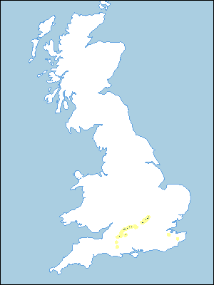
Distribution Map
 |
Note that the yellow shading represents a buffer to highlight the location of very small areas of the association.
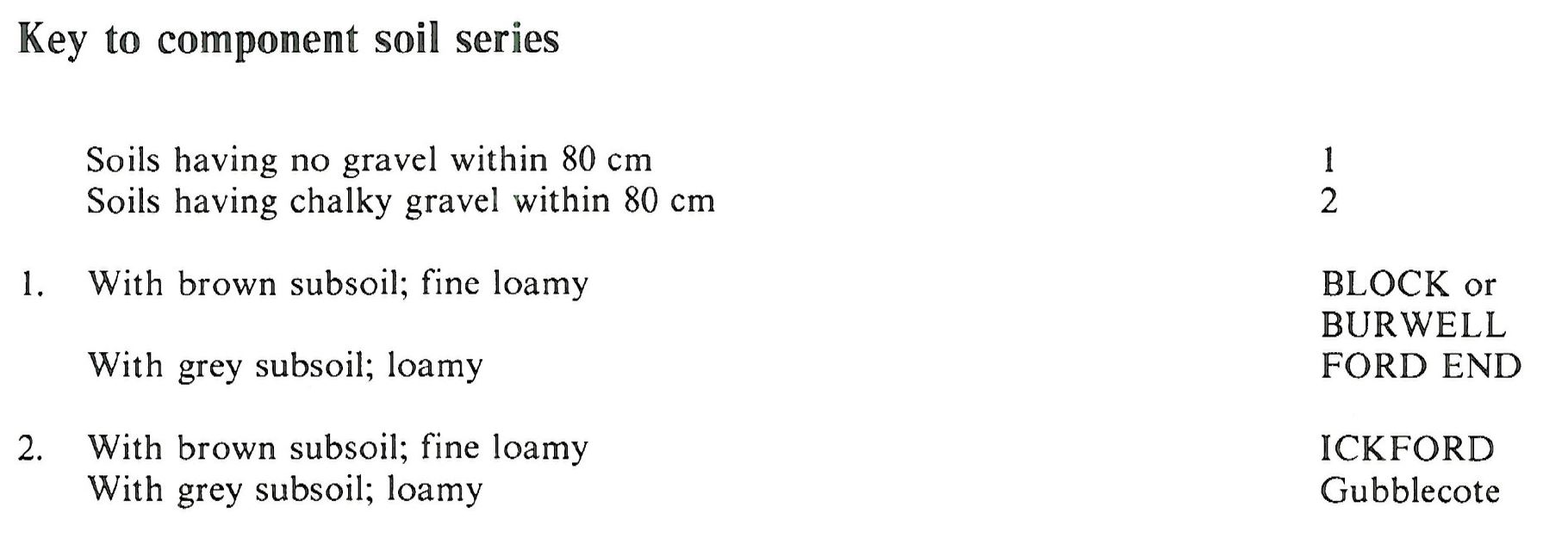
Keys to component soil series
South Eastern Region
 |
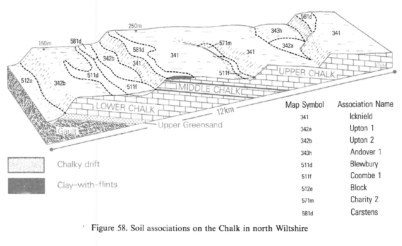
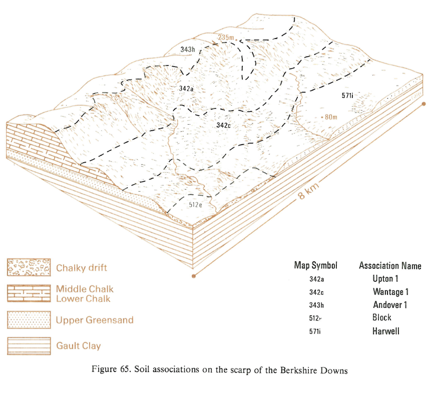
Typical Landscapes
South Western Region
 |
South Eastern Region
 |
All information Copyright, Cranfield University © 2025
Citation: To use information from this web resource in your work, please cite this as follows:
Cranfield University 2025. The Soils Guide. Available: www.landis.org.uk. Cranfield University, UK. Last accessed 25/04/2025
