
Soil Associations
0512f Milton
Soil and site characteristics
Deep permeable calcareous fine loamy soils variably affected by groundwater. Some similar shallower well drained soils over gravel in places. Complex soil patterns locally.
Geology
River terrace and chalky drift
Cropping and Land Use
Cereals, sugar beet and other arable crops.
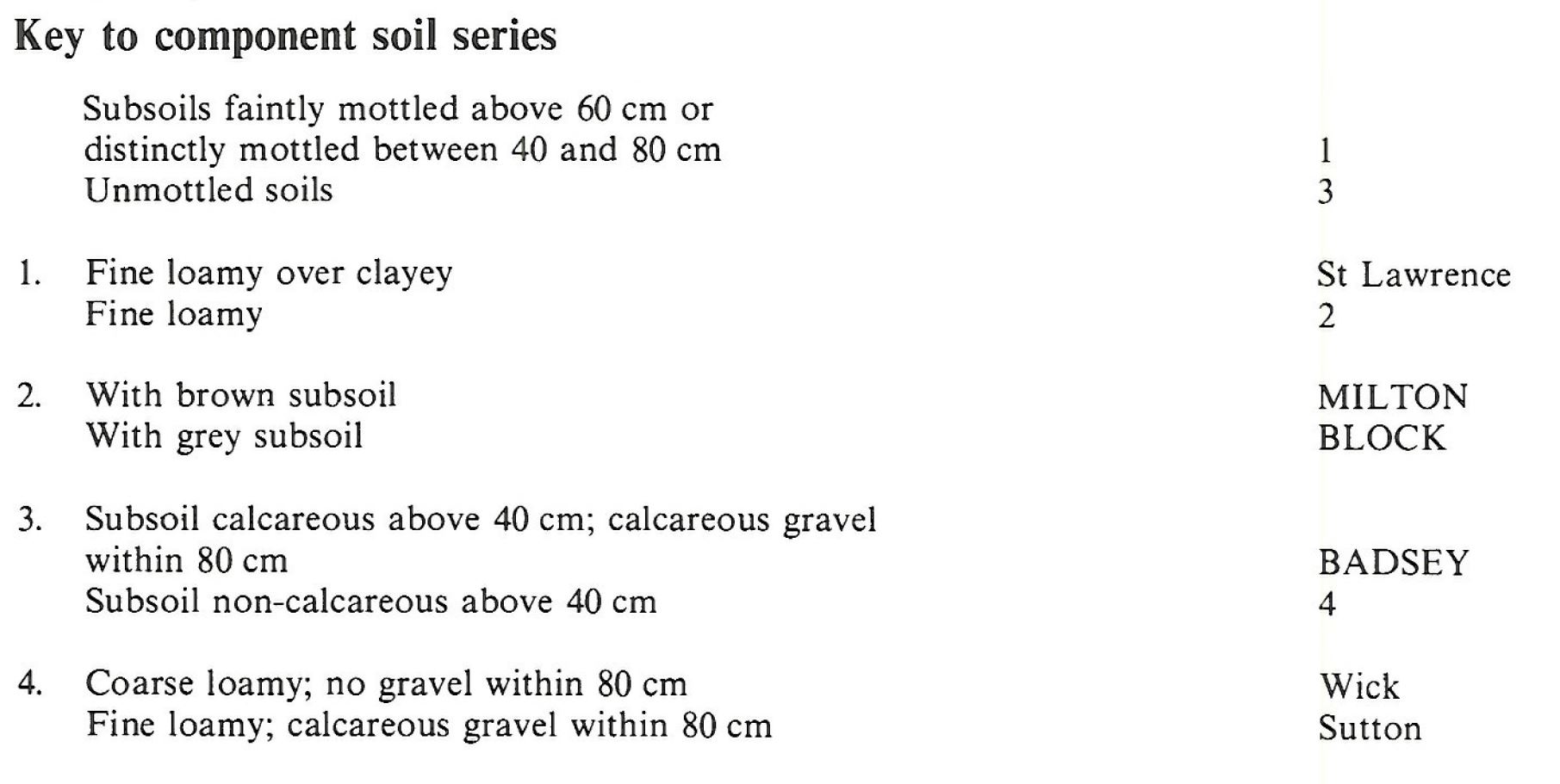
Component soil series
| Subgroup | Series name | Percentage | WRB 2006 link |
|---|---|---|---|
| 5.12 | MILTON | 50% | Calcaric Endogleyic Cambisols |
| 5.12 | BLOCK | 30% | Calcaric Endogleyic Cambisols |
| 5.11 | BADSEY | 20% | Calcaric Endoskeletic Cambisols |
Covers 124 km2 in England and Wales
Soilscapes Classification
| 5 |
Freely draining lime-rich loamy soils |
0512f Milton
Detailed Description
The Milton association consists of permeable, mainly calcareous and fine loamy soils on river terraces or chalky drift on flat ground below 40 m O.D. The association covers 92 km² along the Rhee and Cam valleys from near Letchworth, Hertfordshire to north of Cambridge. There are small outlying areas at Soham, at Somersham and near March. It is a variable association. The main soils are the Milton and Block series, both gleyic brown calcareous earths, the latter with a pale chalky subsoil. Occurring on low-lying level ground with a clay substratum, these soils suffer from occasional subsoil waterlogging in winter. Well drained Badsey soils, typical brown calcareous earths, with chalk gravel in the subsoil and similar coarse loamy soils with sandy subsoils, are common. In summer, crops on Badsey and similar soils suffer from drought. Air photographs often show a polygonal pattern in crops as there is better growth on Milton soils than on Badsey soils within the polygons.
The soils commonly have a more complex sequence of horizons than indicated in the brief descriptions above as they contain lenses and seams of gravel or soil of coarser texture than the main horizons. This variability of the soils results from cryoturbation and the formation of frost wedges during periglacial conditions, as do the polygonal and other soil patterns commonly found. In places in south-west Cambridgeshire, for example, Block and Milton series alternate over a distance of a few metres as the depth to the chalky drift varies. Here Block series predominates near to the Cam and its tributaries. Burwell series also occurs. North of Cambridge the parent material is less chalky and Milton, Badsey series and similar coarse loamy over sandy soils are the most common soils. On the margins where the river terrace deposits are thinnest, St Lawrence series with its grey clayey subsoil, occurs. Some soils in this area are decalcified so small areas of Wick and Sutton soils are found.
In Humberside, the association is at the foot of the slope flanking the western edge of the Ancholme valley, on river terrace drift and gravels derived from the adjoining Lincolnshire Limestone. Here Milton series covers two-thirds of the land. Badsey and Ruskington series also occur, but the Block series is relatively rare.
Soil Water Regime
Milton and Block series are occasionally waterlogged (Wetness Class II) even after drainage treatment. Badsey soils are well drained (Wetness Class I).
Cropping and Land Use
Milton and Block soils, in the Cambridgeshire climate, are slightly droughty for cereals, oilseed rape and sugar beet and moderately droughty for potatoes. The shallower Badsey soils are moderately droughty for all crops. All three are very droughty for grass. The soils are easily worked and there are sufficient days for working the land, both in autumn and spring. A wide range of crops is grown, including cereals, sugar beet, potatoes, vegetables, soft fruit and top fruit.
0512f Milton
Distribution Map
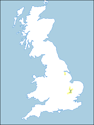 |
Note that the yellow shading represents a buffer to highlight the location of very small areas of the association.
Keys to component soil series
Eastern Region
 |
All information Copyright, Cranfield University © 2025
Citation: To use information from this web resource in your work, please cite this as follows:
Cranfield University 2025. The Soils Guide. Available: www.landis.org.uk. Cranfield University, UK. Last accessed 25/04/2025
