Soil Associations
0513 CANNAMORE
Soil and site characteristics
Deep calcareous and non-calcareous fine loamy and clayey soils with slowly permeable subsoils and slight seasonal waterlogging. Some slowly permeable seasonally waterlogged fine loamy over clayey and clayey soils.
Geology
Chalky till
Cropping and Land Use
Cereals, other arable crops and field vegetables.
Component soil series
| Subgroup | Series name | Percentage | WRB 2006 link |
|---|---|---|---|
| 5.13 | CANNAMORE | 50% | Calcaric Stagnic Cambisols |
| 4.11 | HANSLOPE | 15% | Calcaric Stagnic Cambisols |
| 7.11 | BECCLES | 15% | Eutric Albic Luvic Stagnosols |
| 5.72 | ASHLEY | 10% | Endostagnic Luvisols |
| 5.11 | STRETHAM | 10% | Calcaric Cambisols |
Covers 174 km2 in England and Wales
Soilscapes Classification
| 9 |
Lime-rich loamy and clayey soils with impeded drainage |
0513 CANNAMORE
Detailed Description
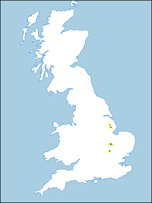
Cannamore association is on chalky till and covers 178 km² in three districts. It occurs in Lincolnshire west of the Wolds from North Willingham south to Mareham le Fen on gently sloping ridges at heights below 130 m O.D. North of Huntingdon in Cambridgeshire, and south and west of Biggleswade in Bedfordshire and Hertfordshire, it occurs mostly on ridge crests below 75 m O.D. The soils are mostly calcareous, fine loamy or clayey, with slowly permeable subsoils and are only occasionally waterlogged. The fine loamy Cannamore series, stagnogleyic brown calcareous earths, covers half the land. Other component soils include Hanslope series (calcareous pelosols), and Stretham series (brown calcareous earths), as well as fine loamy over clayey Ashley series and Beccles series, which respectively belong to the stagnogleyic argillic brown earths and typical stagnogley soils. Eyeworth series (Clayden and Hollis 1984) occurs in Cambridgeshire and Bedfordshire and is similar to the Cannamore series except that it has a clayey subsoil.
In Lincolnshire the association covers 75 km² on the very chalky Calcethorpe Till. Here Cannamore series usually has sandy clay loam upper layers passing to extremely calcareous silty clay loam subsoils. The slowly permeable Beccles series is the main subsidiary soil on crests, but Hanslope and Ashley series occur on slopes. In Cambridgeshire north of Huntingdon the soils, which cover 70 km², contain some aeolian silt in upper horizons, but in Bedfordshire and Hertfordshire the till contains sand derived from the nearby Lower Greensand and covers 32 km² in three discrete areas near Biggleswade. In Cambridgeshire and Bedfordshire, Beccles soils are absent and the main associate soils are Eyeworth, Ashley, Hanslope and Stretham series.
Soil Water Regime
Cannamore and Ashley soils have slowly permeable subsoils and with drainage improvements are briefly waterlogged in winter (Wetness Class II). Stretham series is better drained. Hanslope series has a wetter regime (Wetness Class III). In Lincolnshire the main subsidiary soil, Beccles series, is waterlogged for long periods in winter (Wetness Class IV) where undrained, but drainage measures improve the soil to Wetness Class III. The soils are deep with moderate reserves of available water so that they are slightly droughty for cereals, oilseed rape and sugar beet, and moderately droughty for potatoes. In the drier climate of Cambridgeshire and Bedfordshire the soils are very droughty for grass.
Cropping and Land Use
The Cannamore series is relatively easily worked and is more versatile than the other component soils, but the time available for landwork in winter varies with climate as well as soil. In Lincolnshire, soils are at field capacity on average for more than a month longer than elsewhere in the region. Nevertheless, there are reasonable opportunities in autumn to cultivate the land and harvest sugar beet. In wet years there are limited opportunities for cultivation in spring.
A wide range of crops is grown, but the main crop is cereals, particularly autumn-sown wheat and barley. In Lincolnshire, less oilseed rape and more sugar beet is grown than in Cambridgeshire and Bedfordshire. Around Biggleswade, and to a less extent north of Huntingdon, there are field vegetables, particularly brussels sprouts, partly influenced by the nearby market gardening industry along the river terraces of the Ouse. In Lincolnshire, about one-fifth of the land is grassland carrying both sheep and cattle, whereas in Cambridgeshire and Bedfordshire it covers less than a tenth of the land.
0513 CANNAMORE
Distribution Map
 |
Note that the yellow shading represents a buffer to highlight the location of very small areas of the association.
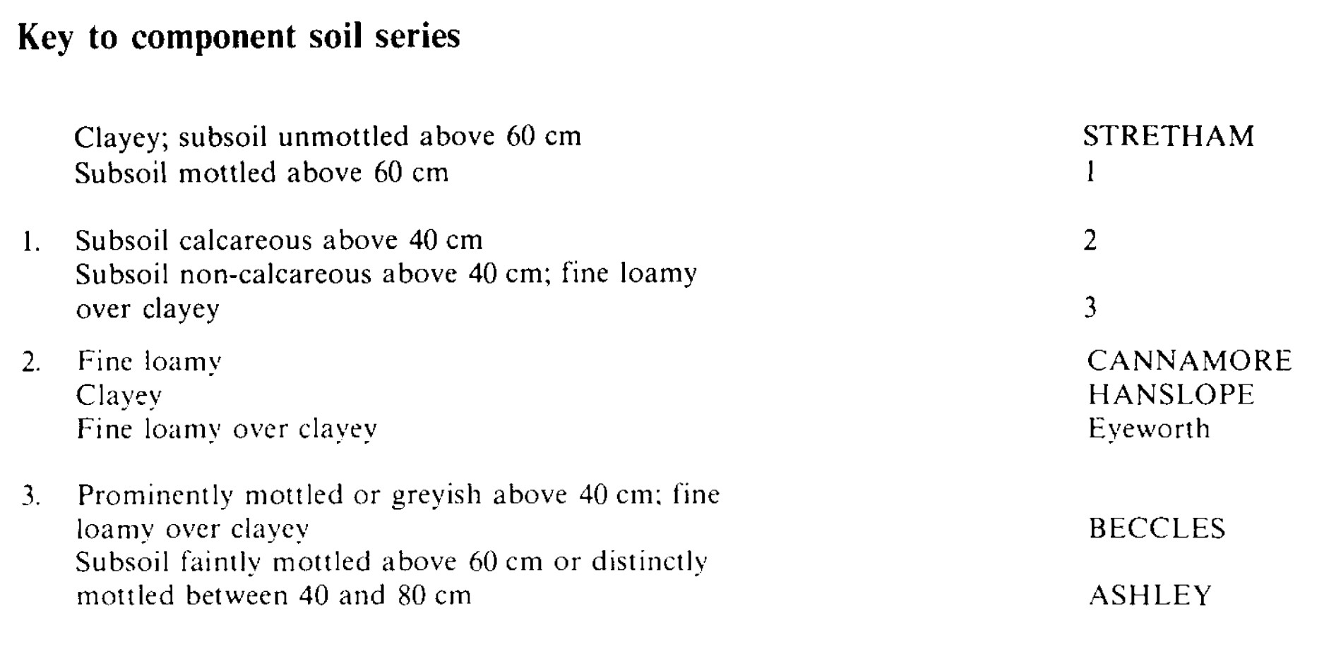
Keys to component soil series
Eastern Region
 |
All information Copyright, Cranfield University © 2025
Citation: To use information from this web resource in your work, please cite this as follows:
Cranfield University 2025. The Soils Guide. Available: www.landis.org.uk. Cranfield University, UK. Last accessed 25/04/2025
