
Soil Associations
0551d NEWPORT 1
Soil and site characteristics
Deep well drained sandy and coarse loamy soils. Some sandy soils affected by groundwater. Risk of wind and water erosion.
Geology
Glaciofluvial drift
Cropping and Land Use
cereals, sugar beet and potatoes; dairying on short term grassland in Cheshire and Wales.
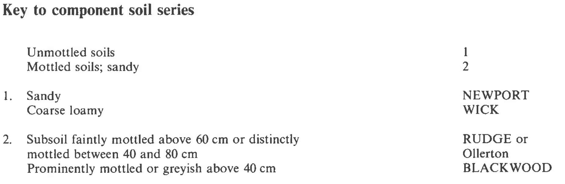
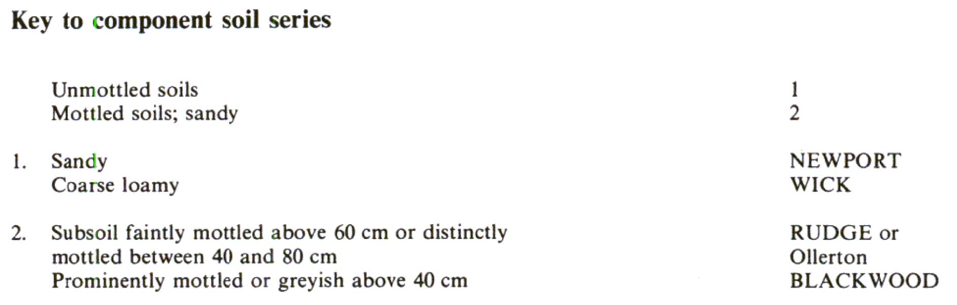
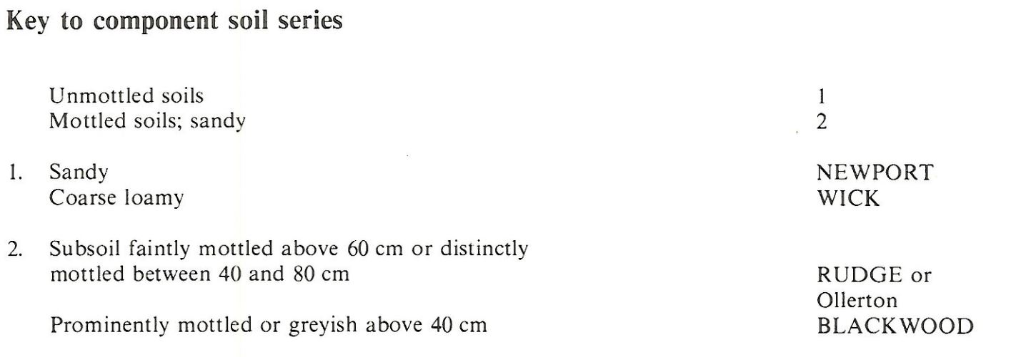
Component soil series
| Subgroup | Series name | Percentage | WRB 2006 link |
|---|---|---|---|
| 5.51 | NEWPORT | 40% | Eutric Arenosols |
| 5.41 | WICK | 20% | Eutric Cambisols |
| 8.21 | BLACKWOOD | 10% | Arenic Mollic Gleysols |
| 5.53 | RUDGE | 10% | Arenic Chromic Endostagnic Luvisols |
Covers 1191 km2 in England and Wales
Soilscapes Classification
| 10 |
Freely draining slightly acid sandy soils |
0551d NEWPORT 1
Detailed Description
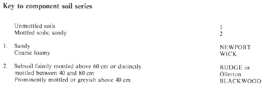
The Newport association consists mainly of well drained medium sandy soils formed in glaciofluvial and river terrace deposits and, in a few places, stoneless, aeolian sand. Although widely distributed in England and Wales the association is rarely extensive but in many wetter districts it provides the only well drained, easily-worked soils suitable for arable use. The principal soil is the Newport series, which belongs to the typical brown sands. Other main soils include the well drained, coarse loamy Wick series (typical brown earths) and the sandy Blackwood series (typical sandy gley soils) which is affected by seasonal groundwater where undrained. The Rudge series, stagnogleyic brown sands, common in some localities, resembles the Ollerton series, except that the subsoil mottling results from a slowly permeable, fine or coarse loamy, subsoil horizon rather than from fluctuating groundwater.
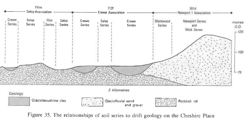
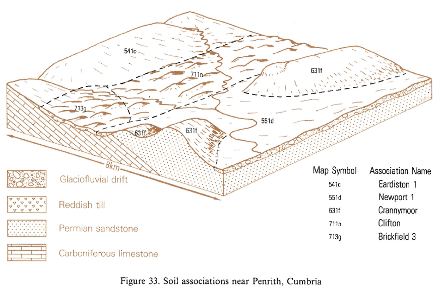
In the Midlands, the most extensive areas are around Harworth, Nottinghamshire and on the Shropshire and Cheshire Plain, particularly south of Whitchurch and around Crewe, Congleton and Delamere Forest. It also occurs in the Greater Manchester conurbation and sporadically on upland fringes of the Lancashire Plain. Near Fradley, however, the association occurs on the terrace deposits of the Trent and Tame. Relief varies from gently to moderately sloping and is often hummocky. Rabbit warrens marked by eroded patches of loose sand commonly occur in glassland on sloping ground. The typical soil pattern is determined by relief and the depth to groundwater. Newport or, where the drift is loamy, Wick series is widespread on dry upper slopes and crests. Seasonal groundwater gives strongly mottled Blackwood series in the lowest sites. The Rudge series occurs at intermediate positions. Other soils include Ollerton series, where groundwater marginally affects the soil profile, Salwick and Clifton series, on lenses of reddish till, and the Quorndon series on seasonally waterlogged coarse loamy drift. Where the land is under heath, or has been reclaimed only recently, Crannymoor series characterized by an ochreous subsoil layer, is likely to be found.
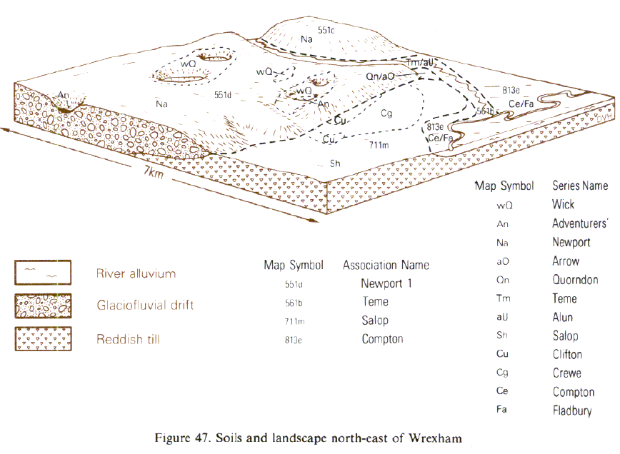
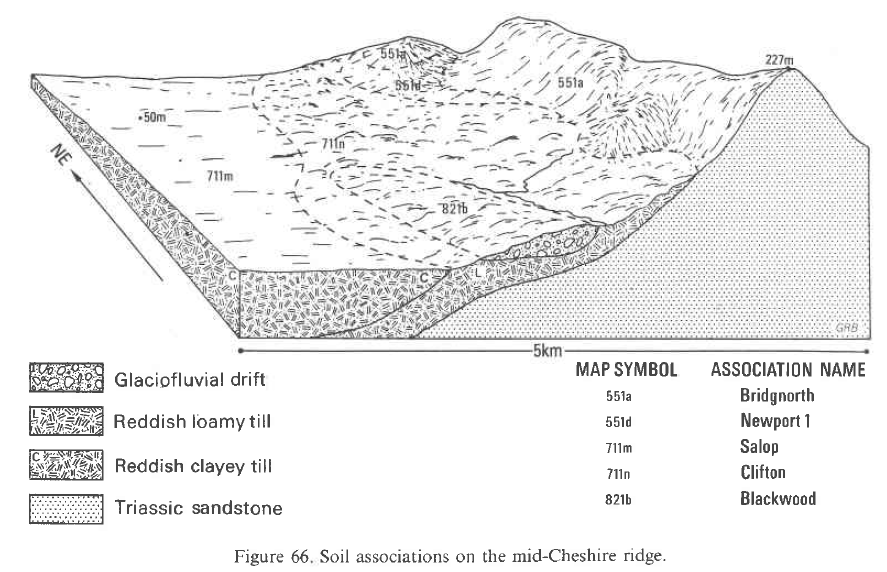
The sandy Bridgnorth and coarse loamy Bromsgrove seriescan be expected near outcrops of reddish Triassic sandstone. In Wales the association occurs on glaciofluvial drift in the Lleyn Peninsula, near Cardigan and on river terrace deposits around Wrexham. Relief varies from gently to moderately sloping and is often hummocky. Rabbit warrens marked by eroded patches of loose sand commonly occur in grassland on sloping ground. The land ranges from 6 m to about 200 m O.D. Exposure is a limitation near the west coast. The typical soil pattern is determined by relief and the depth to groundwater. Newport or, where the drift is loamy, Wick series is widespread on the dry upper slopes and crests. Seasonal groundwater gives strongly mottled Blackwood soils in the lowest sites. The Rudge series is locally important at intermediate positions.
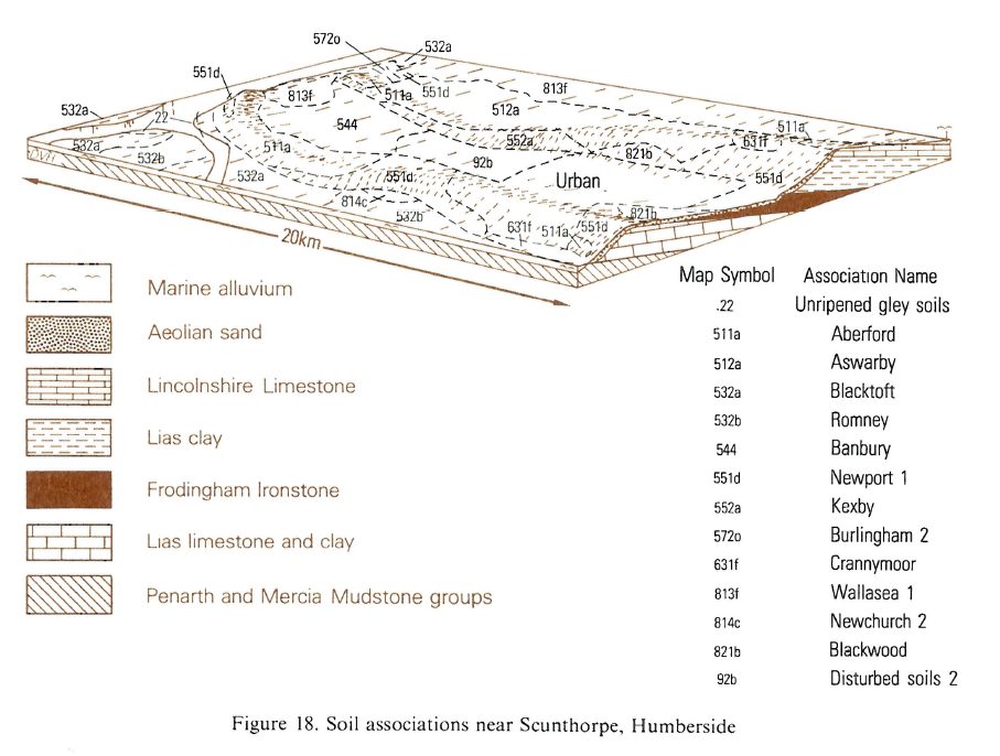
In Eastern England the association occurs between 8 and 60 m O.D. on glaciofluvial sand and gravel, near Norwich, Cromer and Dersingham. The typical soil pattern is determined by relief and groundwater. Newport series is widespread on the upper slopes and crests of undulations, above the reach of groundwater. Downslope however, seasonally rising groundwater gives Ollerton and Blackwood soils on the lowest sites. Rudge series is extensive near Cromer. Other soils found in this locality include the stoneless coarse loamy Sheringham series in valleys where there are additions of aeolian drift, and the Hanworth series where this aeolian drift occurs in depressions and the soils have humose surface horizons. In west Norfolk on the edge of low ground, the Quorndon series is on seasonally waterlogged coarse loamy drift. South of Norwich the Crannymoor series characterized by a dark coloured, humus- and iron-enriched podzolic subsoil layer, is found on ridge crests.
In Northern England the soils are extensive on glaciofluvial sands in the Vale of Eden, between Penrith and Brampton, and on wind-blown sand around Scunthorpe and at the southern edge of the Vale of Pickering. Elsewhere, as on the western margin of the Lake District, in Northumberland and on Humberside, the association occurs mainly as scattered patches on glaciofluvial sand and gravel. Relief varies from gently to moderately sloping and is often hummocky. Extensive rabbit warrens marked by patches of loose sand and other signs of erosion, are common on valley sides in grassland. Altitude is variable, ranging from 3 m to about 140 m O.D.
Soil Water Regime
Free drainage and summer droughtiness are the outstanding features of most of this land. Only the wettest areas are free of drought in most summers. Drainage is not necessary except in low-lying areas where the Blackwood series dominates. Here, field ditches often suffice to remove excess water yet leave groundwater within rooting depth. Newport soils are well drained (Wetness Class I). Waterlogging in the Blackwood series depends on drainage and climate. Where drained they are usually Wetness Class I, but in Lancashire, where agriculture is less intensive and there is no underdrainage, these soils remain seasonally waterlogged (Wetness Class III or IV). Most component soils are very permeable and absorb winter rainwater without run-off and their soil water reserves are small, often less than the crop-adjusted soil moisture deficit, particularly in the drier districts. In north Nottinghamshire in an average year, for example, the Newport and Ollerton series are moderately droughty for most arable crops and very droughty under grassland. Only the wettest areas of Lancashire are not droughty in a normal year. Droughtiness is less severe on Wick soils because of their larger water holding capacity but moisture stress in the Blackwood series lowers yields of potatoes and grass.
Cropping and Land Use
The land is easily worked but productivity is limited, except in the wettest districts, by droughtiness. Good yields are possible where irrigation is available and fertilizer applied. Crops include cereals, potatoes and sugar beet, with grass in the traditional livestock areas. Oilseed rape is also grown as a break crop, especially in Nottinghamshire. In most years soils can be cultivated until the end of December in Nottinghamshire but only to the end of November in Cheshire, although there are opportunities for land work on these light sandy soils throughout the winter. Spring working periods are adequate except in Cheshire and Lancashire in wet seasons when the land may be inaccessible until the end of April. The topsoil commonly has a weak structure, and is subject to slaking and wind erosion where continuous arable crops are grown and the soil is low in organic matter). Compaction and subsequent surface wetness result if the ground is worked under unsuitable conditions, although these can readily be corrected by subsoiling. Surface capping can occur after heavy rain, especially if seedbeds are too fine. Grass yields vary widely.
East of the Pennines and in Shropshire and south Cheshire, grass grows strongly in the spring and there is little risk of poaching, but summer yields are small because of droughtiness. In the wetter districts, grass grows well throughout the season and with little risk of poaching the soils are well suited to grass. Slurry spreading is possible for most of the year on this generally dry land. The soils are able to absorb heavy applications without excessive wetness and run-off. With irrigation, potatoes, carrots, vegetables including brassicas and peas and soft fruit are readily grown and yield well. Clean crops can be harvested well into the autumn. Near towns the land is suitable for pick-your-own fruit and vegetable growing and raising nursery stock. The Newport association provides dry and firm ground so is suitable for golf courses, playing fields and parks.
0551d NEWPORT 1
Distribution Map
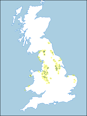 |
Note that the yellow shading represents a buffer to highlight the location of very small areas of the association.
Keys to component soil series
Midlands
 |
Wales
 |
Eastern Region
 |
Northern Region
 |
Typical Landscapes
Wales
 |
Midlands
 |
Midlands
 |
Northern Region
 |
Northern Region
 |
All information Copyright, Cranfield University © 2025
Citation: To use information from this web resource in your work, please cite this as follows:
Cranfield University 2025. The Soils Guide. Available: www.landis.org.uk. Cranfield University, UK. Last accessed 25/04/2025
