
Soil Associations
0551f Newport 3
Soil and site characteristics
Deep well drained sandy and coarse loamy soils. Some coarse and fine loamy soils with slowly permeable subsoils and slight seasonal waterlogging. Risk of wind erosion.
Geology
Glaciofluvial drift and chalky till
Cropping and Land Use
Cereals, sugar beet and peas and beans; some short term grassland.
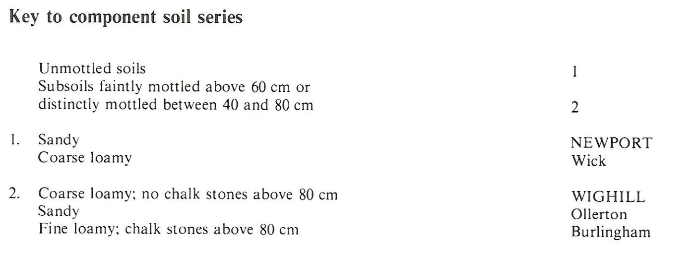
Component soil series
| Subgroup | Series name | Percentage | WRB 2006 link |
|---|---|---|---|
| 5.51 | NEWPORT | 60% | Eutric Lamellic Arenosols |
| 5.72 | WIGHILL | 40% | Endostagnic Luvisols |
Covers 187 km2 in England and Wales
Soilscapes Classification
| 10 |
Freely draining slightly acid sandy soils |
0551f Newport 3
Detailed Description
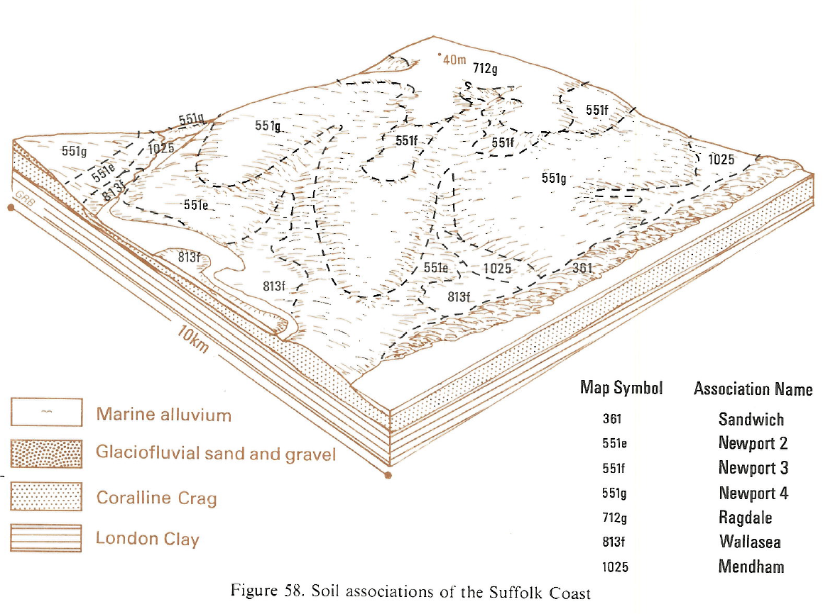
This variable association has mainly well drained sandy and loamy soils covering 194 km² in Norfolk and Suffolk and typically fringes the chalky till. It is found in Suffolk mainly between Lowestoft and Leiston, but there are areas in Norfolk north-west of Norwich, south-west of Attleborough, and smaller parcels near Fakenham and in the valleys of the Waveney and the southern branch of the Little Ouse. The land is flat, sometimes forming platforms in valleys or, more often, gently sloping. The soils are formed in glaciofluvial sands but the component loamy soils are formed in patches of till or Head derived from till. The main soils are the sandy Newport series, typical brown sands, and the less extensive Wighill series, stagnogleyic argillic brown earths, formerly described as Attlebridge series in Norfolk. These cover half or more of the land. The Wighill series is coarse loamy overall, but has more clay in the mottled deep subsoil than in the upper layers although sandy drift occurs at greater depths. The most extensive of the associated soils are the Wick series, the fine loamy Burlingham series on chalky till and the sandyOllerton series on land with a fluctuating groundwater-table.
Although Newport is the most extensive single series, the component loamy soils together cover a larger area. They occur sporadically with Wighill and Burlingham series usually on high ground adjoining the chalky till. Wick soils occur where Head thins over the sands and, together with Newport series with a sandy loam topsoil, often lie between the loamy soils and the sandy Newport series on low ground. South-west of Attleborough on a low platform next to Breckland the soils include much blown sand and here Newport soils are relatively stone-free and Ollerton soils are common. On the flat land north-west of Norwich topsoils are partly developed in aeolian drift so are often of sandy loam texture.
Soil Water Regime
The Newport and Wick series have permeable surface and subsurface layers and are well drained (Wetness Class I). Wighill and Burlingham soils are waterlogged for short periods in winter (Wetness Class II). Ollerton series has a groundwater-table which rises in winter so it is naturally seasonally waterlogged (Wetness Class III) but, being permeable, responds readily to any general water-table control. Other areas, especially west Norfolk have smaller moisture deficits. At Leiston, Newport soils are moderately droughty for cereals and very droughty for potatoes; the loamy soils are slightly to moderately droughty for cereals and oilseed rape, slightly droughty for sugar beet and moderately droughty for potatoes. All soils are very droughty for grass.
Cropping and Land Use
Newport soils are permeable and easily worked, as are Ollerton soils after drainage, and can be cultivated a day or two after rain during much of the field capacity period, although care needs to be taken that subsoils are not so wet that a pan is formed. Wighill and Burlingham series have wet subsoils in most winters even after drainage and, although there are ample opportunities for cultivations in normal years, late harvesting of sugar beet and spring cultivations may sometimes be restricted in the wettest seasons. Management is often complicated by the sporadic occurrences in the same field of loamy and sandy soils requiring different treatments. Diseases such as take-all in cereals are favoured because both drought and waterlogging conditions can be present simultaneously. Crop yields are variable on such sites. The land is arable, the main crops being barley, wheat and sugar beet, but there is some grassland for winter pasture where the association abuts river valleys.
0551f Newport 3
Distribution Map
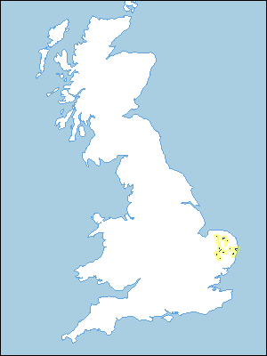 |
Note that the yellow shading represents a buffer to highlight the location of very small areas of the association.
Keys to component soil series
Eastern Region
 |
Typical Landscapes
Eastern Region
 |
All information Copyright, Cranfield University © 2025
Citation: To use information from this web resource in your work, please cite this as follows:
Cranfield University 2025. The Soils Guide. Available: www.landis.org.uk. Cranfield University, UK. Last accessed 25/04/2025
