
Soil Associations
0561b TEME
Soil and site characteristics
Deep stoneless permeable silty soils. Some similar soils variably affected by groundwater. Gravelly subsoil in places. Flat land. Risk of flooding.
Geology
River alluvium
Cropping and Land Use
Dairying and stock rearing on permanent and short term grassland; some cereals where flood risk low.
Component soil series
| Subgroup | Series name | Percentage | WRB 2006 link |
|---|---|---|---|
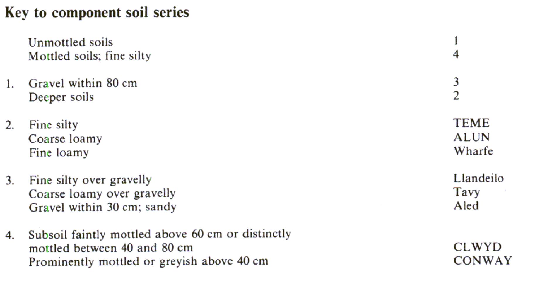
| 5.61 | TEME | 45% | Eutric Fluvic Cambisols |
| 5.62 | CLWYD | 30% | Siltic Fluvic Gleyic Cambisols |
| 8.11 | CONWAY | 20% | Fluvic Eutric Gleysols |
| 5.61 | ALUN | 5% | Eutric Fluvic Cambisols |
Covers 382 km2 in England and Wales
Soilscapes Classification
| 12 |
Freely draining floodplain soils |
0561b TEME
Detailed Description
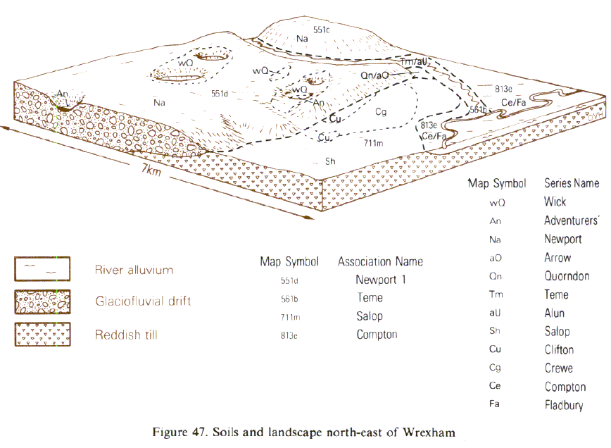
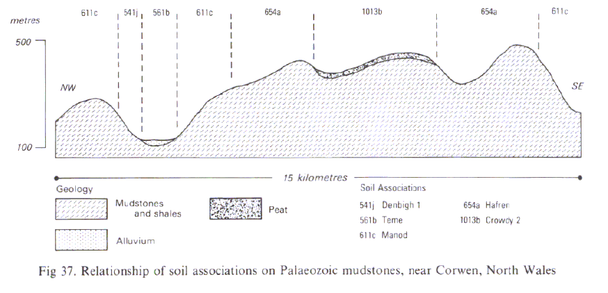
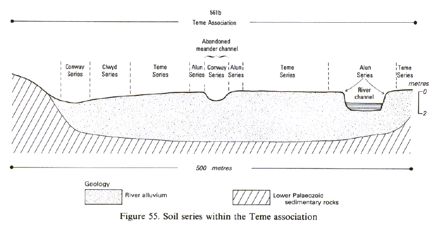
The Teme association occurs on river alluvium in Wales, Northern and South West England and in the Midlands. Deep permeable fine silty typical brown alluvial soils, Teme series, dominate the broader floodplains, covering more than half the land. Wetter fine silty typical alluvial gley soils, Conway series and gleyic brown alluvial soils, Clwyd series, are found mainly along valley margins and within abandoned meanders. There are well drained coarse loamy typical brown alluvial soils of the Alun series near the river or fringing abandoned channels often on the inside of small meanders. Most of the soils are well drained because stream levels are as much as 3 m below the floodplain and the permeable deposits locally rest on gravels. The association is extensive in the Welsh Borderland valleys of the Teme and Wye and in part of the Dane valley in Cheshire. Along the Wye, it stretches from Hay-on-Wye to south of Ross-on-Wye but is less extensive in the Teme valley where it occurs between Leintwardine and Brampton Bryan, and between Onibury and Ludlow. Conway soils are widely included near Willersley and Letton but there are very few Alun profiles in these catchments. Some Wye tributaries drain red Devonian rocks, so here there are small fans of reddish alluvium adjoining the main floodplain giving Lugwardine soils. Along the Dane valley the alluvium is more variable and inclusions of fine loamy Wharfe and Trent soils are common. There are more Clwyd and Conway soils than in Herefordshire and fewer Teme soils which are generally limited to narrow levees. In Wales although the Teme series is generally dominant, on some floodplains other soils are more extensive, for example Clwyd series is the main soil along the Cleddau in south-west Dyfed and the Severn near Caersws. Near Caersws, and along the Tywi, the alluvium is underlain in places by gravel at relatively shallow depth. The Tywi valley is partly floored by fine silty typical brown alluvial soils belonging to Llandeilo series which rest on non-calcareous gravel. Nearby, close to the river, well drained but coarse loamy Tavy soils occur. There are small patches of ranker-like alluvial soils in many valleys, especially their upper reaches. Fine loamy soils of the Wharfe series also occur as minor inclusions and in places where the alluvium is derived from Devonian rocks, reddish Lugwardine, Walford and Mathon soils are included.
In Devon the association is found mainly in the wider parts of the floodplains of the rivers Tamar, Taw, Torridge and Exe but there are smaller delineations in the Bovey and Teign valleys near Newton Abbot and near Yeovil in Somerset. Clayden (1971) and Harrod (1981), who mapped the soils with the former Exe series, illustrate patterns of soil distribution on the Exe and Taw floodplains where variations are closely linked with microrelief. Teme series covers most of the floodplains, but Clwyd, Conway and Crimple series occupy the lower ground. Locally fine loamy typical brown earths of the Newnham series have been included on low river terraces. Around Yeovil, Clwyd series and fine loamy gleyic brown calcareous alluvial soils, Usher series are together more extensive than Teme series and Conway, Wharfe, Trent and Thames series are minor associates. Along the lower Bovey and Teign floodplains, where the alluvium is derived from granite and is more micaceous than usual, Clwyd series, mapped as Bovey series, is most extensive. Ground-water gley soils are also present, particularly in the south-western part of the delineation, and there are Alun and Teign soils on levees close to the river banks.
The association is found along the Swale, south-east of Catterick. The Teme series is dominant but there are fewer Conway soils than elsewhere, and Alun soils are very rare. As the Swale catchment includes Carboniferous Limestone, there are calcareous soils of the Ure and Swale series, as well as Clwyd, Wharfe and Trent series. Some similar alluvial soils are over gravel at shallow depth.
Soil Water Regime
Although most of the soils are permeable and well drained or only occasionally waterlogged (Wetness Class I or II), there is a risk of flooding, particularly in winter. The frequency and duration of floods which depends on location and control measures, are major factors limiting land use. The associated Conway series (Wetness Class IV or V) is waterlogged for long periods and benefits from attention to ditches and outfalls and in places responds well to underdrainage. The soils are generally non-droughty, but are slightly so for grass and potatoes along the Wye near Hereford.
Cropping and Land Use
The Teme association can produce valuable agricultural crops but permanent grass is usually grown because it is least damaged by the floods. Natural fertility is enhanced periodically by the addition of fresh sediments from the flood waters. The good fertility stimulates soil faunal activity including that of earthworms, and this in turn increases the porosity of the soils. These productive meadows are much valued for fattening livestock and grass conservation. The growing season is usually about 7.5 to 9 months (Smith 1976) but the livestock grazing period is often a month or two less if poaching damage is to be avoided. In dry years though most of the growing season in Herefordshire and south Shropshire is available for grazing livestock without risking damage to grass or soil structure. Arable crops are successful where flood risk is small (Thompson 1982). Teme soils are fairly easy to cultivate and require few rain-free days before ploughing. Their large silt content, however, renders them susceptible to capping. The level ground provides for playing fields and temporary summer activities such as camping and caravanning.
0561b TEME
Distribution Map
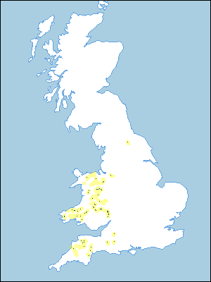 |
Note that the yellow shading represents a buffer to highlight the location of very small areas of the association.
Keys to component soil series
Wales
 |
Midlands
 |
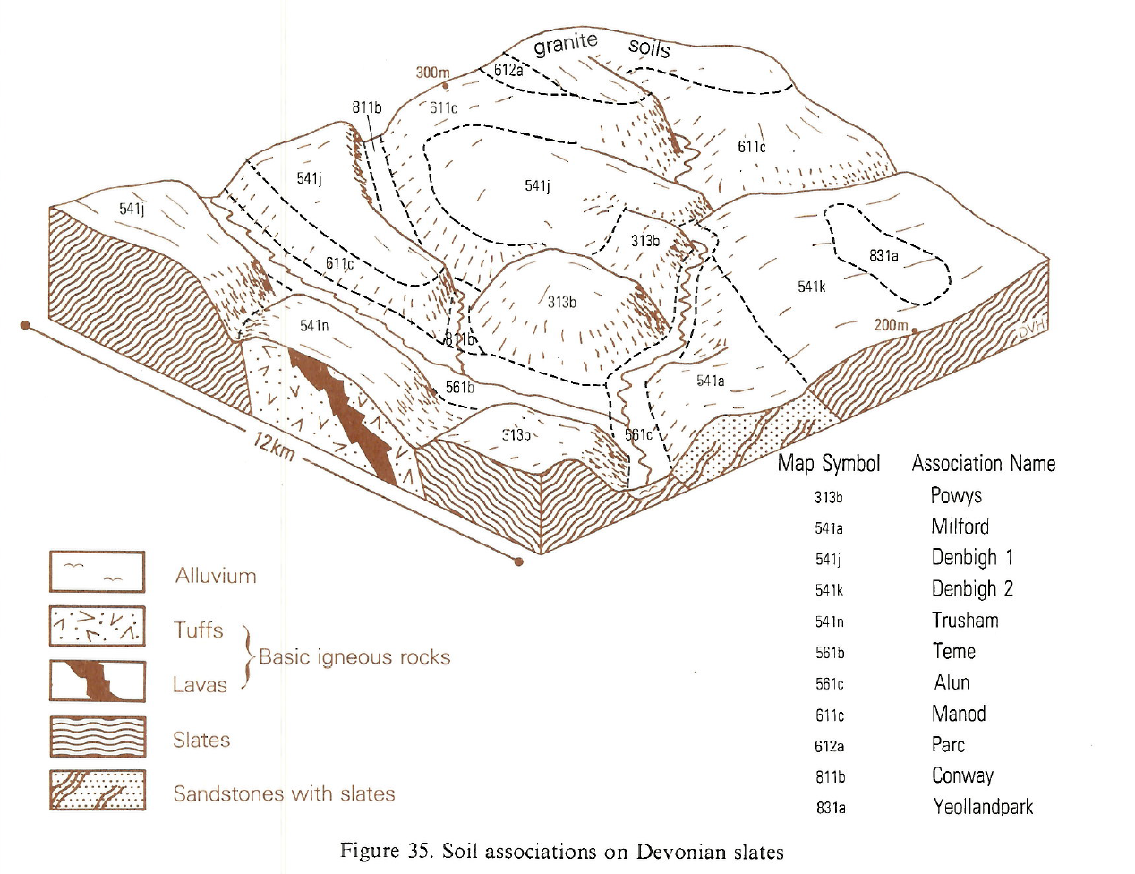
Typical Landscapes
South Western Region
 |
Wales
 |
Wales
 |
Wales
 |
All information Copyright, Cranfield University © 2025
Citation: To use information from this web resource in your work, please cite this as follows:
Cranfield University 2025. The Soils Guide. Available: www.landis.org.uk. Cranfield University, UK. Last accessed 25/04/2025
