
Soil Associations
0571o MELFORD
Soil and site characteristics
Deep well drained fine loamy over clayey, coarse loamy over clayey and fine loamy soils, some with calcareous clayey subsoils.
Geology
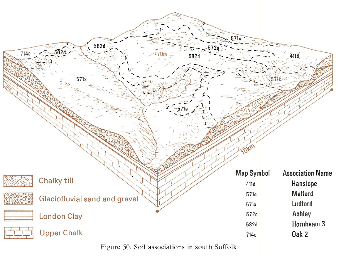
Chalky till
Cropping and Land Use
Cereals, sugar beet and other arable crops.
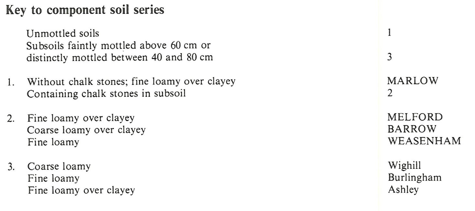
Component soil series
| Subgroup | Series name | Percentage | WRB 2006 link |
|---|---|---|---|
| 5.71 | MELFORD | 30% | Chromic Luvisols |
| 5.71 | WEASENHAM | 20% | Haplic Luvisols |
| 5.81 | MARLOW | 10% | Profundic Chromic Luvisols |
| 5.81 | BARROW | 10% | Profundic Chromic Luvisols |
Covers 333 km2 in England and Wales
Soilscapes Classification
| 7 |
Freely draining slightly acid but base-rich soils |
0571o MELFORD
Detailed Description
The Melford association consists of loamy over clayey soils developed over thin chalky till at the margins of the till plateau of Suffolk, Essex and Hertfordshire with small outliers in Norfolk and Northamptonshire. It is 291 km² in extent. The soils are mostly well drained and occur on the gentle and moderate slopes of valleys dissecting the plateau where the till and locally-derived Head thin out over permeable chalk or glaciofluvial deposits. There are broader spreads on level ground or moderate north-facing slopes around Bury St Edmunds, and near Sudbury and Ipswich. Melford and Weasenham series, both argillic brown earths, are the main component soils, covering half the land. They are developed in thin fine loamy superficial drift over clayey or fine loamy chalky till, respectively. Chalk stones usually occur within a metre depth. Marlow and Barrow series, covering about a fifth of the land, are fine and coarse loamy soils with reddish clayey subsoils. They are typical paleo-argillic brown earths, containing subsoil material weathered during one or more temperate periods of the Pleistocene and incorporated into the present soils either by cryoturbation or solifluction. Most component soils have permeable stony subsoils with many small chalk stones in an extremely calcareous well-fissured matrix resting on glaciofluvial sands and gravels or chalk. In a few places where the till is thicker, the subsoils are slowly permeable and are grey with ochreous mottles giving fine loamy over clayey Ashley soils, fine loamy Burlingham soils, both with chalky subsoils, and the deep coarse loamy Wighill series.
Barrow series is dominant around Bury St Edmunds where blown sand from the nearby Breckland has been incorporated into the upper horizons of the soils. Here undulations in the subsoil caused by cryoturbation during the last glaciation form complex soil patterns. Weasenham series and the coarse loamy Moulton series are the main subsidiary soils. Between Saffron Walden and Hertford, along the Stort, Ash and Rib valleys, soils of the Ludford, Hall and Newport series occur on lower valley slopes in glaciofluvial gravels and Head and correspond to the former Thundridge and Chelmer associations mapped by Thomasson (1969). Here, locally, Ludford series covers as much as a fifth of the land. In places along the upper slopes there is a narrow zone of Stretham series.
Soil Water Regime
Melford, Weasenham, Marlow and Barrow series are permeable and well drained (Wetness Class I), but Ashley, Burlingham and Wighill series with their mottled subsoils are occasionally waterlogged (Wetness Class II). Soil moisture reserves available for crop growth are moderate. For cereal crops, sugar beet and oilseed rape the main soils are slightly or moderately droughty in average years and moderately droughty in dry years. For shallow rooting crops like potatoes the soils are all moderately droughty and for grass they are very droughty.
Cropping and Land Use
The well drained soils are easily cultivated and because the average return to field capacity is late there are a large number of machinery work days in autumn. There is an adequate period for spring cultivations. Cultivations on the occasionally waterlogged Ashley, Burlingham and Wighill series need more careful timing. The most common farming system is four or five years in cereals followed by a break crop of sugar beet, field beans or oilseed rape.
0571o MELFORD
Distribution Map
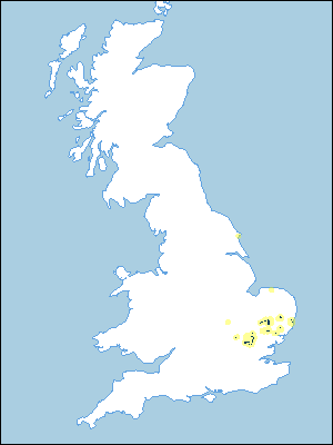 |
Note that the yellow shading represents a buffer to highlight the location of very small areas of the association.
Keys to component soil series
Eastern Region
 |
Typical Landscapes
Eastern Region
 |
All information Copyright, Cranfield University © 2025
Citation: To use information from this web resource in your work, please cite this as follows:
Cranfield University 2025. The Soils Guide. Available: www.landis.org.uk. Cranfield University, UK. Last accessed 25/04/2025
