
Soil Associations
0572c HODNET
Soil and site characteristics
Reddish fine and coarse loamy soils with slowly permeable subsoils and slight seasonal waterlogging. Some similar well drained reddish fine loamy soils. Slight risk of water erosion.
Geology
Permo-Triassic and Carboniferous reddish mudstone, siltstone and sandstone
Cropping and Land Use
Cereals, some sugar beet and potatoes; some grassland.
Component soil series
| Subgroup | Series name | Percentage | WRB 2006 link |
|---|---|---|---|
| 5.72 | HODNET | 45% | Chromic Endostagnic Luvisols |
| 5.71 | NORTH NEWTON | 10% | Chromic Luvisols |
| 5.72 | MIDDLETON | 10% | Chromic Endostagnic Luvisols |
| 5.72 | STAUNTON | 10% | Eutric Chromic Endostagnic Luvisols |
| 5.72 | WHIMPLE | 10% | Chromic Endostagnic Luvisols |
Covers 557 km2 in England and Wales
Soilscapes Classification
| 8 |
Slightly acid loamy and clayey soils with impeded drainage |
0572c HODNET
Detailed Description
This association covers 419 km² in the Midlands and South West England on interbedded reddish Permo-Triassic, Carboniferous and Devonian mudstones, siltstones and sandstones. These rocks support deep, loamy, reddish soils which occur on gentle to moderate slopes and are capable of growing a wide range of crops. The constituent Hodnet, Staunton, Middleton and Whimple series are all stagnogleyic argillic brown earths which differ from each other in soil texture and in the nature of the underlying rocks. Hodnet soils are usually dominant; they are fine loamy and rest on interbedded sandstones and siltstones. Staunton soils are similar but coarse loamy. The fine silty Middleton series is found on siltstones or silty shales and the fine loamy over clayey Whimple series occurs where thin drift overlies mudstone. All these soils have ochreous mottles or faint gleying on ped faces in the subsoil. The well drained fine loamy North Newton series (typical argillic brown earths) passes to sandstone, siltstone or shale and is a particularly common constituent of the association in South West England. This association is extensive (322 km²), particularly in Leicestershire, Nottinghamshire and Derbyshire on interbedded fine grained sandstone and mudstone of the Colwick Formation and lower beds of the Mercia Mudstone Group. Hodnet series is generally dominant and Staunton, Whimple and Middleton soils each occupy less than a fifth of the land. North Newton soils are common between Nottingham and West Markham only. In places in Nottinghamshire there is a narrow strip of green mudstones along the boundary with the Cuckney 1 association and these give Dale and Wickham series. The association is common between Derby and Ashbourne and forms a wide fringe to the South Derbyshire coalfield, where Bromsgrove and Eardiston soilsare included on thin sandstones. Here too are occasional Salwick and Wick soils on small patches of glaciofluvial drift. The Hodnet association is also mapped on the Keele and Enville Beds of the Upper Coal Measures in Warwickshire, north Worcestershire and south-east Shropshire. Here Whimple series is often more common than Hodnet series and Brockhurst and Lilles hall soils are included locally. The soils formerly mapped near Nuneaton and near Kenilworth as Dodmoor, Kenilworth and Baxterley series are now included with the Whimple, Hodnet and Brockhurst soils respectively. West of the Severn, the association includes small river terraces with Wick series and some Heapey and Ticknall soils are included on greyish shales of the Highley Beds near Upper Arley.
South-east of Newent, however, in Gloucestershire Staunton and Melbourne series are the main soils and, on the Devonian outcrop around Thornbury and Sharpness Middleton, Hodnet and Netchwood series are dominant. In Somerset the association occurs on interbedded Triassic siltstone, sandstone and mudstone around Flax Bourton, Chew Magna, Chew Stoke, Hallatrow and Taunton. Around Chew Stoke there are significant areas of wetter Greinton soils on valley floors, with Whimple and Worcester soils on scarp footslopes. North Newton and similar coarse loamy soils occur extensively on undulating land around Hallatrow and Chew Stoke and further south around Taunton.
Soil Water Regime
Slowly permeable horizons in the subsoil of the Hodnet, Middleton, Staunton and Whimple series restrict downward percolation and these soils are occasionally waterlogged. Normally this is for short periods in winter (Wetness Class II) but in the wet districts (more than 150 F.C. days), Hodnet, Middleton and Whimple soils can be waterlogged for longer periods (Wetness Class III). North Newton soils are permeable and well drained (Wetness Class I). The soils readily accept excess winter rain and delay run-off, but surface capping of cultivated soils during storms or prolonged periods of heavy rain can significantly reduce infiltration, resulting in rill erosion.
Cropping and Land Use
The loamy soils of the association have a moderate retained water capacity so timing of cultivation is important. Nevertheless, they form land of above average quality which is extensively used for cereal and root crops. Opportunities for cultivation are greatest in autumn and so winter cereals are preferred. Root cropping is more widespread in the east Midlands where a long spring landwork period and a late autumn return to field capacity permits harvesting with little risk of soil damage. For all arable crops, the available water capacity of the component soils is generally adequate, except potatoes in dry districts. All soils are suitable for the direct drilling of winter cereal crops but are less suited for spring sowings. There is some horticulture locally, particularly around Woodborough in Nottinghamshire and Melbourne in Derbyshire. In Shropshire much of the land is under grass, either permanent on the steeper slopes or as leys in an arable rotation. Dairying or stock rearing are important even though there is a significant poaching risk on Middleton, Whimple and Hodnet series and drought can curtail summer growth.
Regular liming is required only on the coarser Staunton soils, others requiring only occasional liming to maintain pH in surface horizons. The base status is generally high and potassium and magnesium are slowly released by weathering of the parent material. Phosphorus contents depend on recent fertilizer dressings.
0572c HODNET
Distribution Map
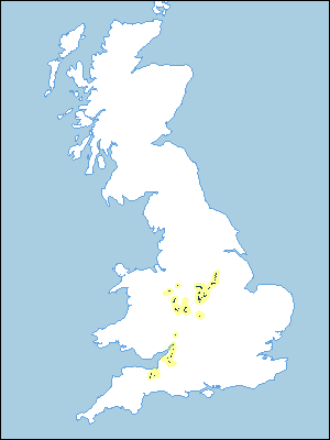 |
Note that the yellow shading represents a buffer to highlight the location of very small areas of the association.
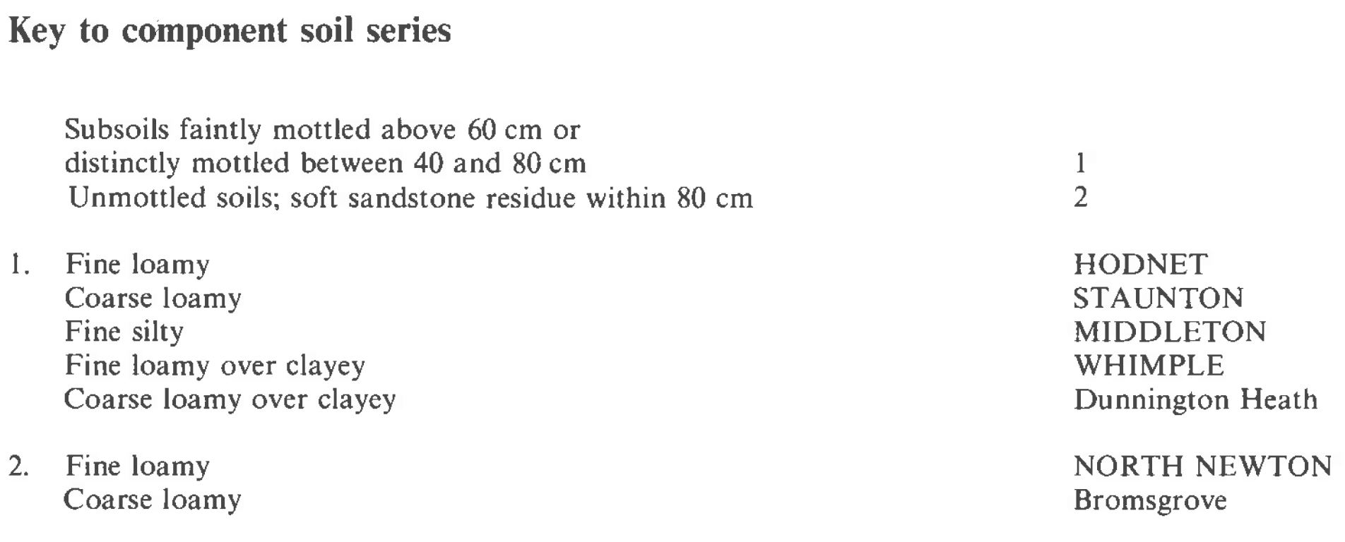
Keys to component soil series
South Western Region
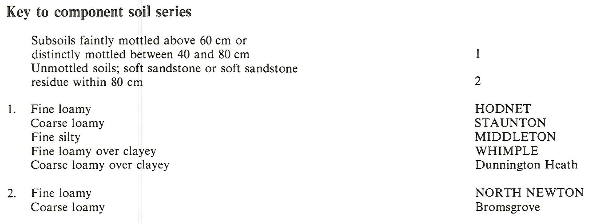 |
Midlands
 |
All information Copyright, Cranfield University © 2025
Citation: To use information from this web resource in your work, please cite this as follows:
Cranfield University 2025. The Soils Guide. Available: www.landis.org.uk. Cranfield University, UK. Last accessed 25/04/2025
