
Soil Associations
0572f WHIMPLE 3
Soil and site characteristics
Reddish fine loamy or fine silty over clayey soils with slowly permeable subsoils and slight seasonal waterlogging. Some similar clayey soils on brows. Slowly permeable seasonally waterlogged fine loamy and fine silty over clayey soils on lower slopes.
Geology
Drift over Permo-Triassic and Carboniferous reddish mudstone
Cropping and Land Use
Dairying and stock rearing; winter cereals and short term grassland.
Component soil series
| Subgroup | Series name | Percentage | WRB 2006 link |
|---|---|---|---|
| 5.72 | WHIMPLE | 50% | Chromic Endostagnic Luvisols |
| 4.31 | WORCESTER | 20% | Chromic Vertic Luvisols |
| 7.11 | BROCKHURST | 15% | Chromi-Albic Luvic Planosols |
Covers 1657 km2 in England and Wales
Soilscapes Classification
| 8 |
Slightly acid loamy and clayey soils with impeded drainage |
0572f WHIMPLE 3
Detailed Description
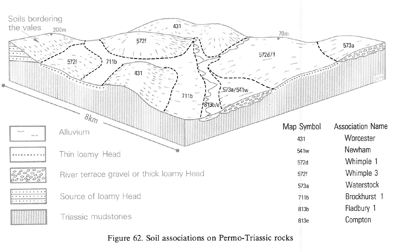
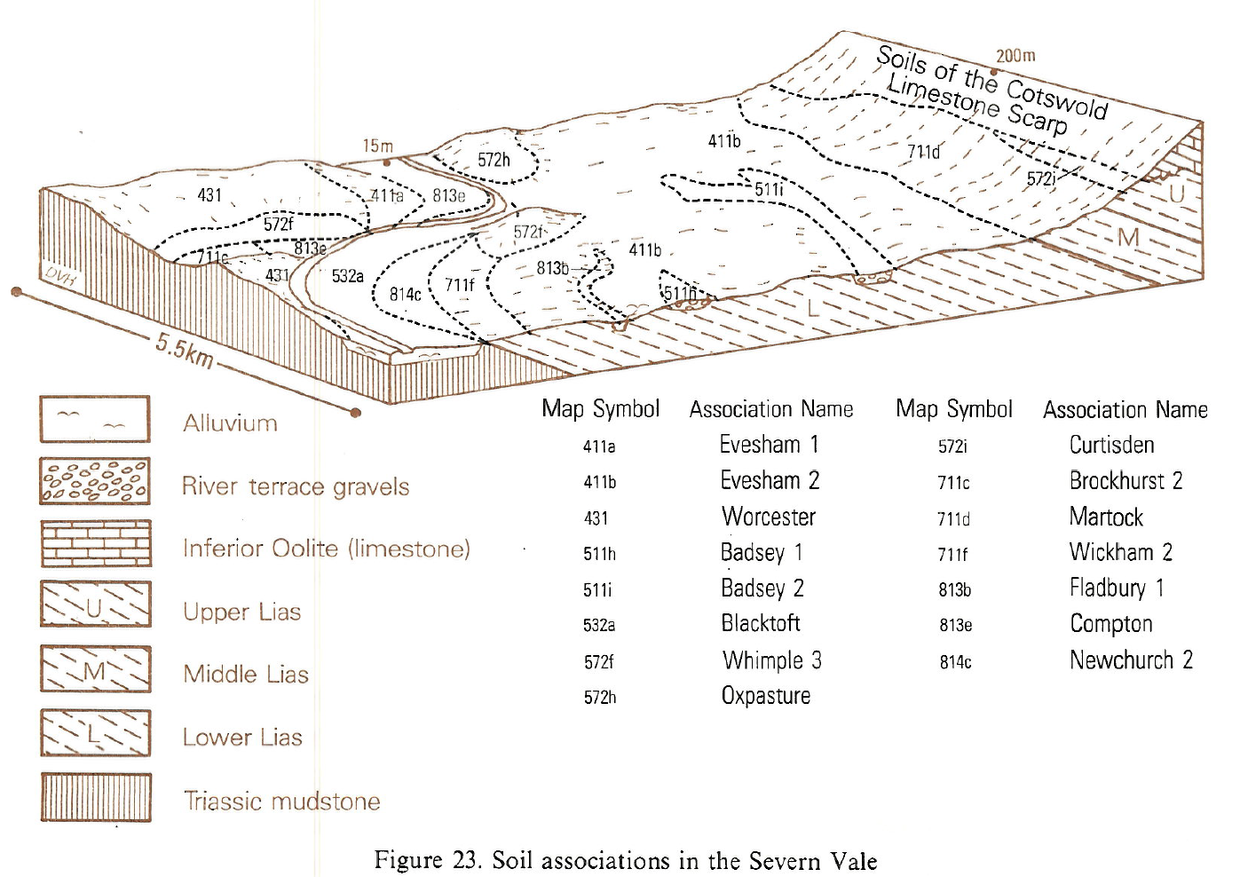
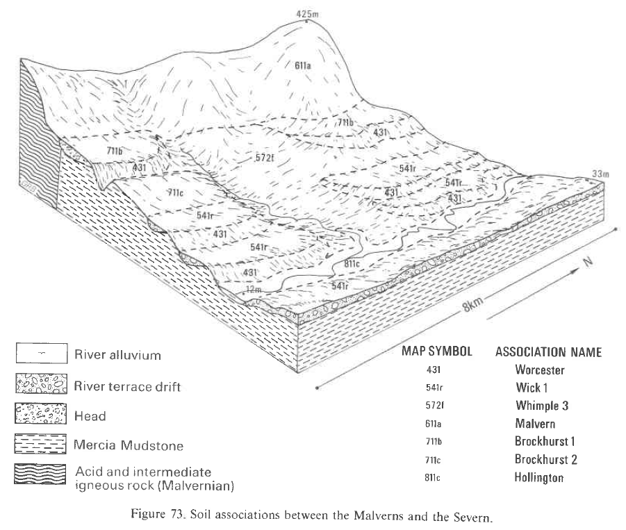
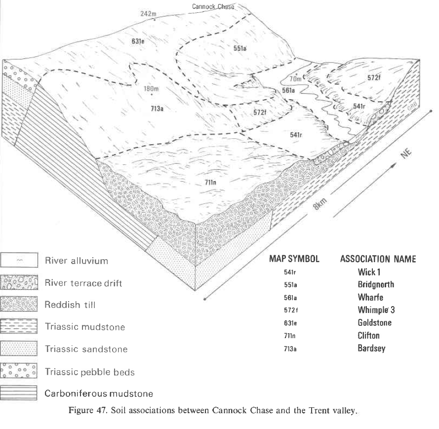
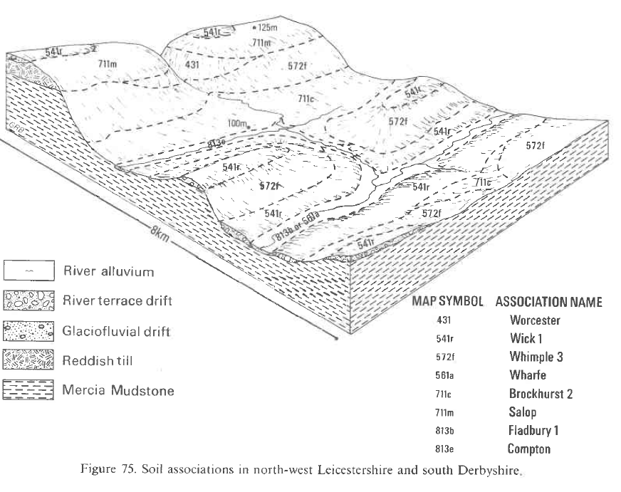
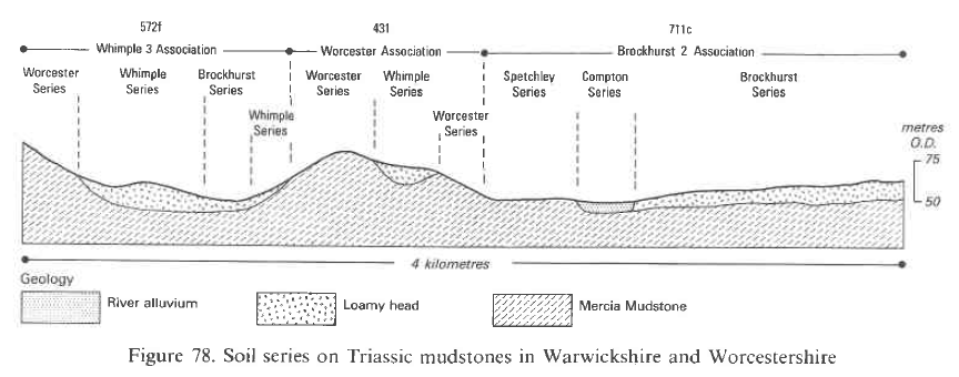
This association of seasonally waterlogged reddish fine loamy or fine silty over clayey soils, developed in thin drift over Permo-Triassic and Carboniferous mudstone or clay shale, is widespread (1,543 km²) in the Midlands and South West England, mainly on moderate slopes. It also includes reddish clayey soils developed directly in the mudstone and wet soils on gently sloping ground. The soils occur mainly over Triassic mudstones, though in Devon they mostly overlie Permian beds. In parts of Staffordshire they are developed in mudstones of the Upper Coal Measures. Altitudes range from 10 to 230 m O.D. though most of the land lies between 50 and 150 m O.D. The dominant Whimple series, of the stagnogleyic argillic brown earths, has fine loamy or fine silty drift horizons overlying slowly permeable mudstone or clay shale and is found mainly on gentle or moderate slopes. Steeper drift-free slopes support the Worcester series which is reddish and clayey throughout and belongs to the typical argillic pelosols. Gently sloping land in receiving sites carries fine loamy or fine silty over clayey soils of the Brockhurst series, belonging to the typical stagnogley soils. Fine loamy soils of the where the drift is thick, fine loamy over clayey Flint soils are included. Clayey Spetchley soils are found on some flat receiving sites and occasional profiles of the Dunnington Heath series occur on slopes where thin coarse loamy drift overlies mudstone. Locally in narrow valleys there are thin strips of Compton series in alluvium too small to be shown separately on the map. The association is extensive (1,085 km²) throughout the Midlands, mainly in Hereford and Worcester, Staffordshire, Derbyshire and Warwickshire, but also in Nottingham-shire and Leicestershire. Whimple series is predominant everywhere with Worcester series the main associate. The soils are found widely around Bromsgrove and Worcester, and extend down the Severn as far as Tewkesbury. They also occur between Great Witley and Great Malvern. In these localities Brockhurst and Spetchley soils are important with Compton soils only along narrow valleys. In central Staffordshire, the association is found on moderate slopes of the Trent, Blithe and Sow valleys where geological erosion has stripped most of the former cover of glacial drift. Here Brockhurst soils are confined to wet hollows and lower slopes. In some places, drift more than a metre thick gives Flint soils. Around Stoke-on-Trent, on reddish Carboniferous mudstones, clayey soils are much less common than on the Triassic beds further south and the main subsidiary soil is the Brockhurst series. In the Dove valley to the west of Derby and in parts of north-west Leicestershire, Whimple and Worcester soils are co-dominant with a few fine loamy Hodnet soils where sandstones and siltstones are interbedded with the clay and mudstone. South of Birmingham on the slopes of the Arrow and Avon valleys, Whimple and Worcester soils occur almost exclusively though around Henley-in-Arden interbedded sandstones and greenish grey marls give more loamy Hodnet soils than elsewhere. West of Leicester Brockhurst soils are common associates. In Nottinghamshire, Whimple soils occupy about two-thirds of the association which is mainly on gentle slopes flanking the river Trent east of Nottingham. Dunnington Heath soils are common locally but Worcester soils are mainly restricted to moderately sloping land or to steep river bluffs as near Kneeton. In this same area and further north near Wheatley, Walkeringham and on a hilltop near Oxton, well drained silty soils such as Barton and Wheatley series are included on bands of siltstone skerries.
The association is extensive (460 km²) in Devon, Somerset, Avon and Gloucestershire, over Triassic and Permian reddish mudstone. The thin loamy Head overling the mudstones is derived from various local rocks. Near Exeter topsoils contain large rounded stones from the Budleigh Salterton Pebble Beds. Further east in Devon and in adjoining parts of Somerset, the Head is from the Greensand and contains chert stones, but around the Quantock and Mendip Hills, stones from Palaeozoic rocks are found.
Soil Water Regime
Whimple and Worcester soils suffer slight seasonal waterlogging (Wetness Class III) in many districts but in the drier parts of the region, Whimple soils can have a better water regime (Wetness Class II). Brockhurst soils are usually waterlogged for long periods in winter (Wetness Class IV) though with drainage in districts where the annual average rainfall total is less than about 750 mm, the duration of waterlogging is shorter (Wetness Class III). Little excess winter rain is absorbed because all these soils have slowly permeable subsoils. All the soils can benefit from underdrainage which is most necessary for Brockhurst soils.
Cropping and Land Use
Almost all the land is in agricultural use though cropping varies considerably from one district to another. In Worcestershire and Nottinghamshire, arable farming predominates, the main crops being winter cereals sown in rotation with short-term grass and oilseed rape or occasional fodder crops such as kale. Sugar beet and potatoes are included in the rotation in Nottinghamshire. Cultivations are normally confined to slopes of less than 8 degrees and are mostly on Whimple rather than Worcester or Brockhurst soils. The period suitable for landwork is more than adequate in Worcestershire and Nottinghamshire, but in Lancashire there are fewer good machinery work days, particularly in spring, which results in a larger proportion of long-term grassland. Dairy cattle are widespread on long-term grassland in Staffordshire, Derbyshire and Warwickshire. Beef cattle are locally important but sheep are numerous only on higher ground. The topsoils of Worcester and Brockhurst series, and to a lesser extent those of the Whimple series, are water retentive which with their slowly permeable subsoils causes surface wetness and a strong risk of poaching. These soils are very susceptible to smearing and compaction when farm operations are mistimed. Opportunities for landwork in winter are negligible and often long delayed by wet weather in spring or autumn. Under continuous arable cropping deep subsoiling (60 cm) is necessary to break up plough pans. All component soils are very droughty for grass in the east and south-west of the region , with reserves of water barely adequate here for cereals. In south Derbyshire, Staffordshire and Warwickshire, there is a moderate drought risk for grass in normal years but this is only slight for cereal crops.
Cropping varies considerably from one district to another, in north-west Gloucestershire arable farming predominates, as in the Midlands, the main crops being winter cereals sown in rotation with short term grass and occasional fodder crops such as kale. The soils are generally not suitable for potatoes or horticultural crops. Opportunities for landwork are adequate in Gloucestershire, but further south-west there are fewer good machinery work days, particularly in spring, which results in a larger proportion of permanent grassland. These soils are also very susceptible to smearing and compaction when farm operations are mistimed. Opportunities for landwork in winter are negligible and often long delayed after wet weather in spring or autumn.
The climate of Avon, Devon and Somerset promotes good grass growth, though increased yields can be offset by wetter ground conditions in spring and autumn which lead to poaching damage. Because there are insufficient good machinery work days dairying is the main enterprise. In these wetter areas poaching risk is considerable, particularly on Worcester and Brockhurst soils. While summer droughtiness does not affect cereal cropping in the region, it limits grass production particularly in north-west Gloucestershire.
Nutrient reserves are naturally good, the underlying mudstone being rich in potassium, calcium and magnesium. Lime and nitrogen are necessary to maintain fertility though slow permeability ensures that leaching losses are minimal.
0572f WHIMPLE 3
Distribution Map
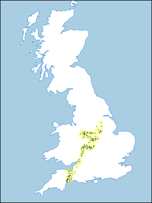 |
Note that the yellow shading represents a buffer to highlight the location of very small areas of the association.
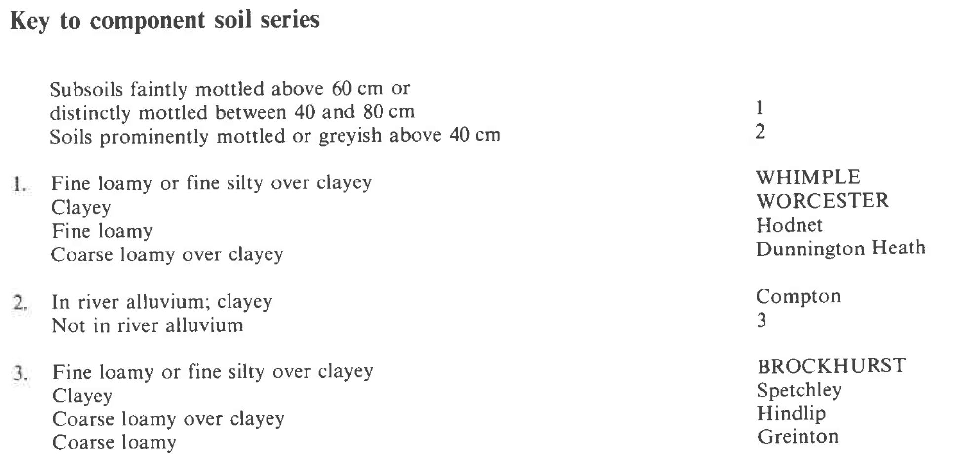
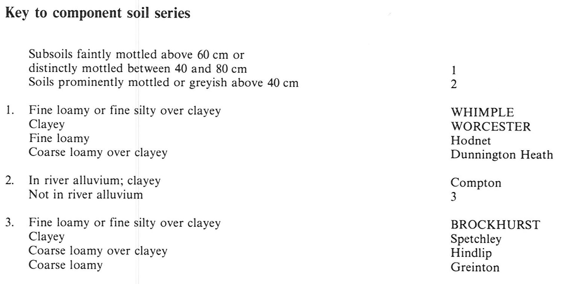
Keys to component soil series
Midlands
 |
South Western Region
 |
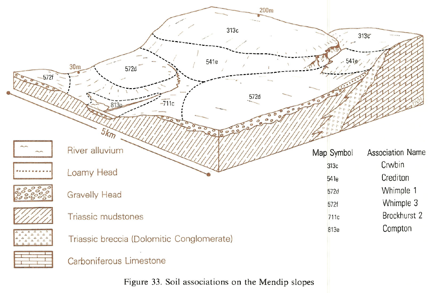
Typical Landscapes
South Western Region
 |
South Western Region
 |
South Western Region
 |
Midlands
 |
Midlands
 |
Midlands
 |
Midlands
 |
All information Copyright, Cranfield University © 2025
Citation: To use information from this web resource in your work, please cite this as follows:
Cranfield University 2025. The Soils Guide. Available: www.landis.org.uk. Cranfield University, UK. Last accessed 25/04/2025
