
Soil Associations
0572j Bursledon
Soil and site characteristics
Deep fine loamy soils with slowly permeable subsoils and slight seasonal waterlogging associated with deep coarse loamy soils variably affected by groundwater. Some slowly permeable seasonally waterlogged loamy over clayey soils. Landslips and associated irregular terrain locally.
Geology
Eocene and Jurassic loam and clay
Cropping and Land Use
Grassland with dairying and some cereals in the South West but cereals in Hertfordshire and Essex; some horticultural crops.
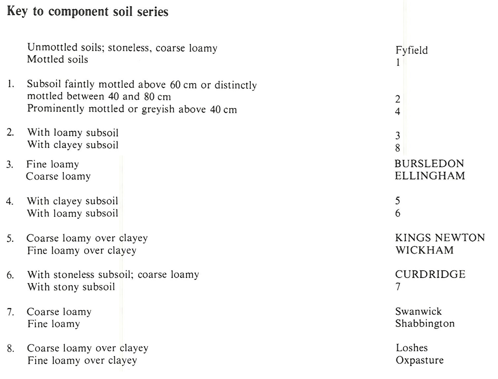
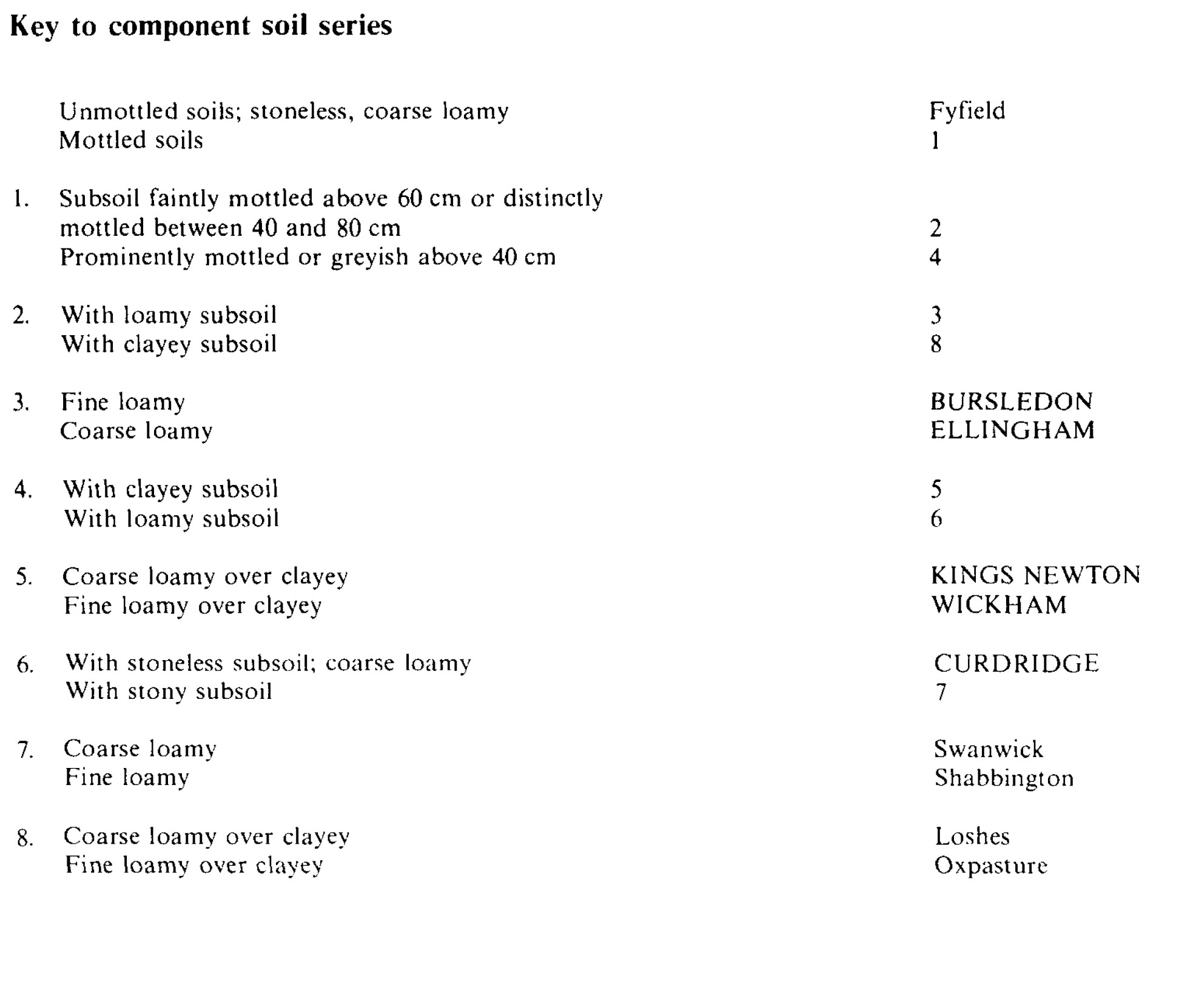
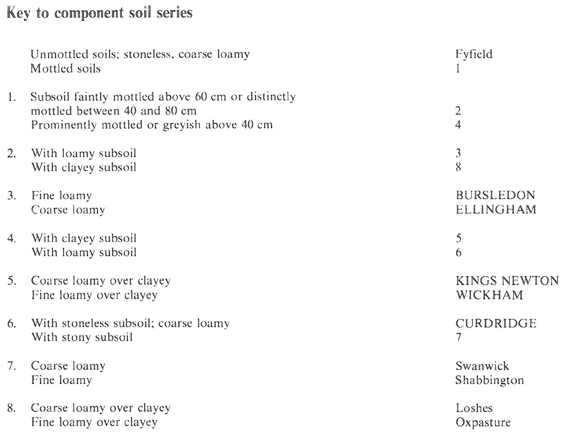
Component soil series
| Subgroup | Series name | Percentage | WRB 2006 link |
|---|---|---|---|
| 5.72 | BURSLEDON | 30% | Endostagnic Luvisols |
| 7.11 | WICKHAM | 16% | Eutric Luvic Planosols |
| 5.73 | ELLINGHAM | 15% | Endogleyic Luvisols |
| 8.41 | CURDRIDGE | 15% | Luvic Gleysols |
| 7.11 | KINGS NEWTON | 11% | Ruptic Eutric Luvic Stagnosols |
Covers 316 km2 in England and Wales
Soilscapes Classification
| 8 |
Slightly acid loamy and clayey soils with impeded drainage |
0572j Bursledon
Detailed Description
The Bursledon association includes loamy soils in Tertiary and Jurassic formations in southern England. Interbedded towns, sands and clays give rise to soils of varied drainage status. The main soils, fine loamy Bursledon series, are stagnogleyic argillic brown earths with mottled slowly permeable subsoils below a thick brownish subsurface horizon. Similar, but more permeable, coarse loamy Effingham soils (gleyic argillic brown earths} are locally common, while more strongly mottled coarse loamy Curdridgc soils, typical argillic gley soils, are found on low-lying land affected by groundwater and springs. Fine loamy and coarse loamy over clayey and strongly mottled, slowly permeable Wickham and Kings Newton soils (typical stagnogleys) are found in thin, often stony loamy drift over clay.
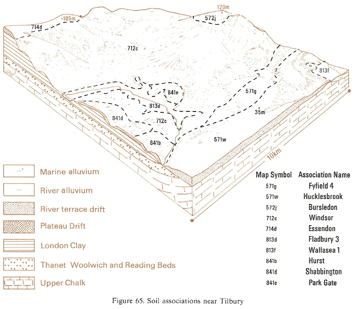
In Hertfordshire, narrow outcrops of Reading Beds carrying Loshes and Oxpasture soils and some wetter Curdridge and Wickham soils have been mapped with the association. In Essex near Brentwood and Southend, on Bagshot and Claygate Beds, Bursledon, Curdridge and Wickham soils occur with inclusions of coarse loamy over clayey Bolderwood and Essendon soils.
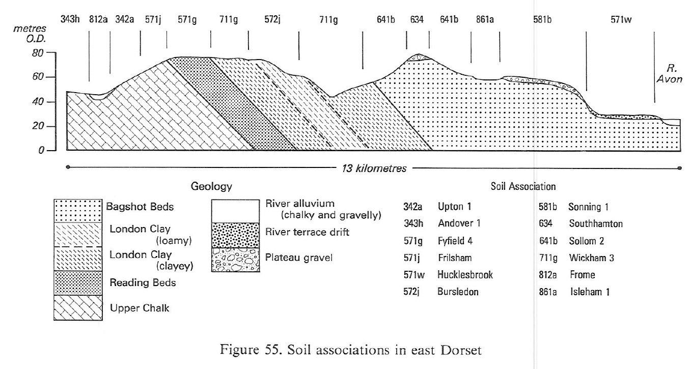
In the gently-rolling London Clay country of south-east Dorset, Bursledon and Curdridge soils are in low-lying sites, some alongside streams. Ellingham soils are found where the underlying beds are somewhat coarser, while well drained loamy Fyfield soils and sandy Frilford soils, are developed on parts of the Reading Beds outcrop. Clay bands give Wickham soils, which are common amongst Bursledon soils in and east of Savernake Forest, Wiltshire. Over the entire Tertiary outcrop patches of stony loamy drift are common, with seasonally waterlogged Swanwick and Shabbington soils, and well drained Ludford soils. The loamy Corallian and Forest Marble beds in north Dorset, Somerset and north Wiltshire have Bursledon soils with Oxpasture, Wickham and Curdridge soils. Fyfield and Frilford soils occur on local outcrops of sands within the Forest Marble. North of Bromham, many slopes are affected by land slipping. Small areas of Lower Greensand in north Dorset have a similar range of soils to the Corallian outcrop.
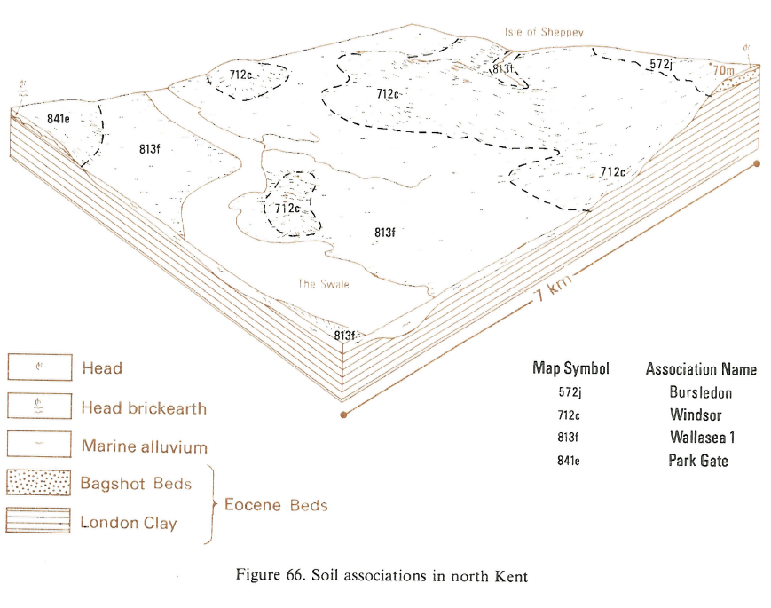
In South East England these soils are on undulating land over Reading, Bracklesham and Bagshot Beds. Although Bursledon soils predominate, the coarse loamy Ellingham series is the main soil in places, often in association with coarse loamy over clayey Loshes soils. Sandy Frilford soils and coarse loamy Fyfield soils occur on sandy beds, commonly capping low hills. Swanwick and Shabbington soils in stony loamy drift and coarse loamy Curdridge soils passing to clay and sand are all affected by groundwater. Sandy podzols, Shirrell Heath series, are found locally on heaths over Bagshot Sands. Thin loamy drift over Tertiary clay gives Kings Newton and Wickham soils, often on gently sloping or flat land, whereas better drained Oxpasture soils are found on more undulating land. In the west of the New Forest a similar sequence of soils occurs on the Bracklesham and Barton Beds. Well drained Maplestead and Hucklesbrook soils are developed on river terraces in north-east Surrey. On the Isle of Wight closely interbedded sands, loans and clays give complex lateral changes in soils, principally Bursledon, Ellingham, Fyfield, Oxpasture, Curdridge and Wickham series. Chalk drift in some valleys gives Coombe and other calcareous soils, and small areas of Waterstock and other soils on river terraces near Freshwater are also included.
Soil Water Regime
Many of the soils have slowly permeable subsoils causing intermittent or seasonal waterlogging in the undrained state. After drainage, waterlogging varies (Wetness Class II and III) depending on soil and site. Successful drainage on the wetter soils is often difficult to achieve and each situation needs careful assessment, particularly of the location of springs and the risk of ochre deposition in pipes. Ellingham and Curdridge Soils are permeable but are affected by spring seepage, or groundwater. They respond well to drainage treatment. Frilford and Fyfield are permeable and well drained (Wetness Class I).
Cropping and Land Use
The topsoils of most constituent series are fine and coarse loamy and there is little risk of structural damage provided the groundwater, which affects most of the soils in their undrained state, is controlled by drainage. Bursledon soils provide plenty of opportunities for landwork in autumn in contrast to the wetter, more difficult, Wickham and Curdridge soils. The better drained soils support arable, and to a lesser extent horticultural, cropping. Where drainage is not carried out, or is unsuccessful, grass is the main crop. The soils are droughty for grass and potatoes and, without irrigation, yields are restricted. The risk of poaching is slight on drained Bursledon soils but Wickham and Curdridge soils poach readily.
0572j Bursledon
Distribution Map
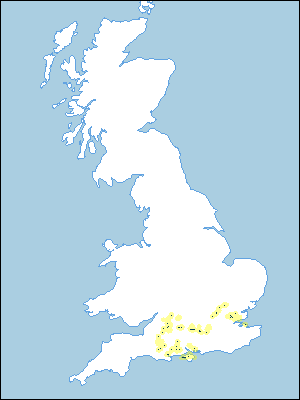 |
Note that the yellow shading represents a buffer to highlight the location of very small areas of the association.
Keys to component soil series
South Western Region
 |
Eastern Region
 |
South Eastern Region
 |
Typical Landscapes
South Western Region
 |
Eastern Region
 |
South Eastern Region
 |
All information Copyright, Cranfield University © 2025
Citation: To use information from this web resource in your work, please cite this as follows:
Cranfield University 2025. The Soils Guide. Available: www.landis.org.uk. Cranfield University, UK. Last accessed 25/04/2025
