
Soil Associations
0572l FLINT
Soil and site characteristics
Reddish fine loamy over clayey soils with slowly permeable subsoils and slight seasonal waterlogging. Some similar fine loamy soils and some slowly permeable seasonally waterlogged fine loamy over clayey soils.
Geology
Reddish till
Cropping and Land Use
Cereals, potatoes and sugar beet and some horticultural crops in drier lowlands, grassland in moist districts.
Component soil series
| Subgroup | Series name | Percentage | WRB 2006 link |
|---|---|---|---|
| 5.72 | FLINT | 45% | Chromic Endostagnic Luvisols |
| 5.72 | SALWICK | 25% | Chromic Endostagnic Luvisols |
| 7.11 | SALOP | 10% | Chromic Eutric Albic Luvic Stagnosols |
Covers 393 km2 in England and Wales
Soilscapes Classification
| 8 |
Slightly acid loamy and clayey soils with impeded drainage |
0572l FLINT
Detailed Description
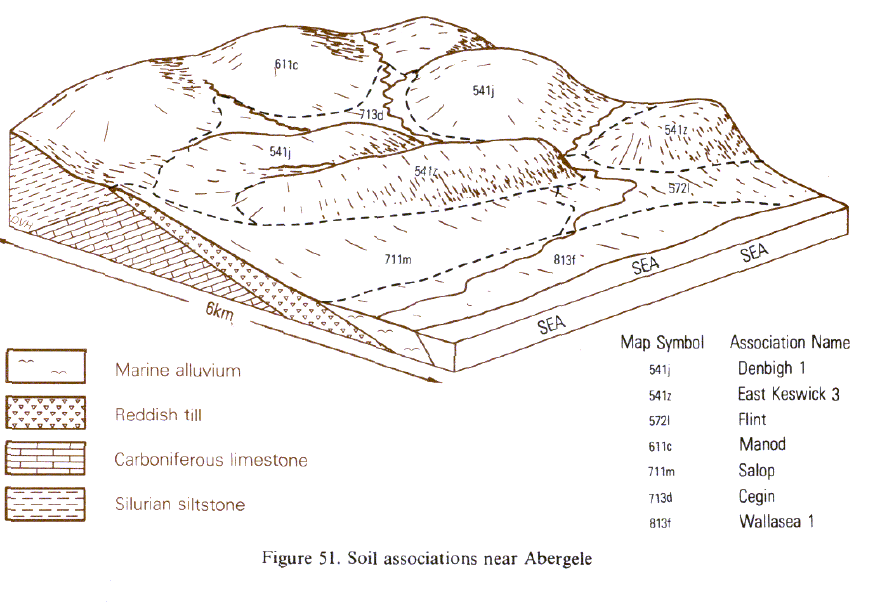
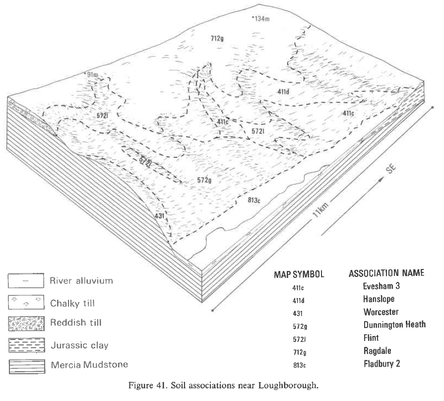
This association consists mainly of stagnogleyic argillic brown earths in thick reddish drift. The principal soils belong to the fine loamy over clayey Flint and the fine loamy Salwick series, both with slowly permeable subsoils which impede downward water movement. The association is widespread in the region particularly in Lancashire and also occurs in Wales, and Northern England. The parent material is till or Head derived largely from Triassic mudstone but contains hard Triassic quartzite pebbles; also stones from the igneous formations of the Lake District, south-western Scotland and Ireland. The development of Flint and Salwick soils in drift which normally carries wetter soils is variously explained by steep slopes, dry climate, permeable beds of sand and gravel within the drift at depths below 1 m or the presence of permeable bedrock within a few metres depth. As well as Flint and Salwick series, there are typical stagnogley soils belonging to the Salop and Clifton series. This association is mapped in lowland Lancashire, in the Soar valley in Leicestershire and Nottinghamshire, in Staffordshire and Warwickshire and as isolated pockets around Manchester. Coarse, often sandy, outwash deposits on the Lancashire plain give associate coarse loamy over fine loamy soils (Salwick, Nupend, Clifton and Claverley serie) and some that are coarse loamy throughout (Wick and Arrow series) as well as Flint and Salop soils. In the Soar valley glaciofluvial deposits have contributed coarse material to the upper horizons giving Nupend and Astley Hall soils (Beard 1984) but also coarse loamy Wick, Arrow and Escrick soils. Salop profiles are only found on some flat hilltops. In Staffordshire, the unit occurs around Needwood Forest and Eccleshall. In Warwickshire it is most extensive between Rugby and Hinckley on gentle slopes in the Avon valley. Developed on Wolstonian drift, it also occurs in small valleys on the edge of the chalky till plateau where streams have cut through to the Lower Wolston Clay. There are inclusions of Salop series mainly on lower ground. This association is mapped along the north coast of Wales and on Anglesey where it was previously mapped as Cottam and Flint series. On Anglesey, limestone bedrock is often within 2 to 3 m depth and slopes are up to 10 degrees, giving relatively well drained soils that ancillary Salop soils are rare. On the mainland, the association is found on gently sloping land along the coast, and here Salop series occupies small basins and level ground. In Eastern England in Lincolnshire it covers less than 2 km² on high ground south-west of Louth.
The association is mapped in Humberside, North Yorkshire and the far north of Northumberland but is nowhere extensive. In Humberside, Flint and Salwick soils are developed in decalcified chalky till. Where the drift contains chalk fragments, fine loamy profiles of Burlingham and Holderness series are present. Reddish brown stagnogley soils of the Salop and Clifton series occur on flatter ground. Less common are the fine loamy East Keswickand fine loamy over clayey Kearby and Dunkeswick series.
Soil Water Regime
Dense slowly permeable subsoils cause some degree of waterlogging in most soils. In drier climates with less than about 125 field capacity days per year, appropriate drainage measures confine waterlogging to occasional periods and to deeper horizons below 50 cm depth (Wetness Class II). In wetter climates, drainage measures can alleviate conditions in surface horizons, but seasonal waterlogging remains (Wetness Class III). The soils absorb winter rainwater fairly rapidly but there is some surface run-off. There is generally enough water available for cereals, grass and potatoes so that droughtiness is nowhere severe although grass production is restricted by drought in some drier districts.
Cropping and Land Use
These soils provide good mixed farming land. In the west cultivation is restricted by wetness in spring, but in the drier districts much of the land is regularly cultivated. In the Soar valley half is arable in any year whereas on the Fylde arable crops are rare. Autumn cultivation is most desirable as it is least likely to cause structural damage to the soil. Only in dry areas, as around Loughborough, can regular spring cultivations be made safely for cereals, potatoes and sugar beet. Direct drilling on these soils gives comparable yields of autumn-sown crops but yields of spring cereals will be lower than those sown conventionally. While deep subsoils are sometimes calcareous, topsoils benefit from periodic liming and in the past marling has satisfied this need. There is not much potassium and phosphorus naturally but amounts vary according to past farming practice. Grassland production in the east is affected by drought in most years. Topsoils have a moderate capacity to retain water so that there is little poaching risk in drier areas but a moderate risk elsewhere. In Lancashire, where there is adequate moisture and a usable flush of autumn growth, the soils are well suited to grassland. On Anglesey where the field capacity period is longer than 225 days, they are less suited to arable cropping. Here wetness restricts spring cultivation and autumn-sown crops are more reliable.
0572l FLINT
Distribution Map
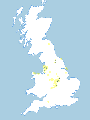 |
Note that the yellow shading represents a buffer to highlight the location of very small areas of the association.
Keys to component soil series
Midlands
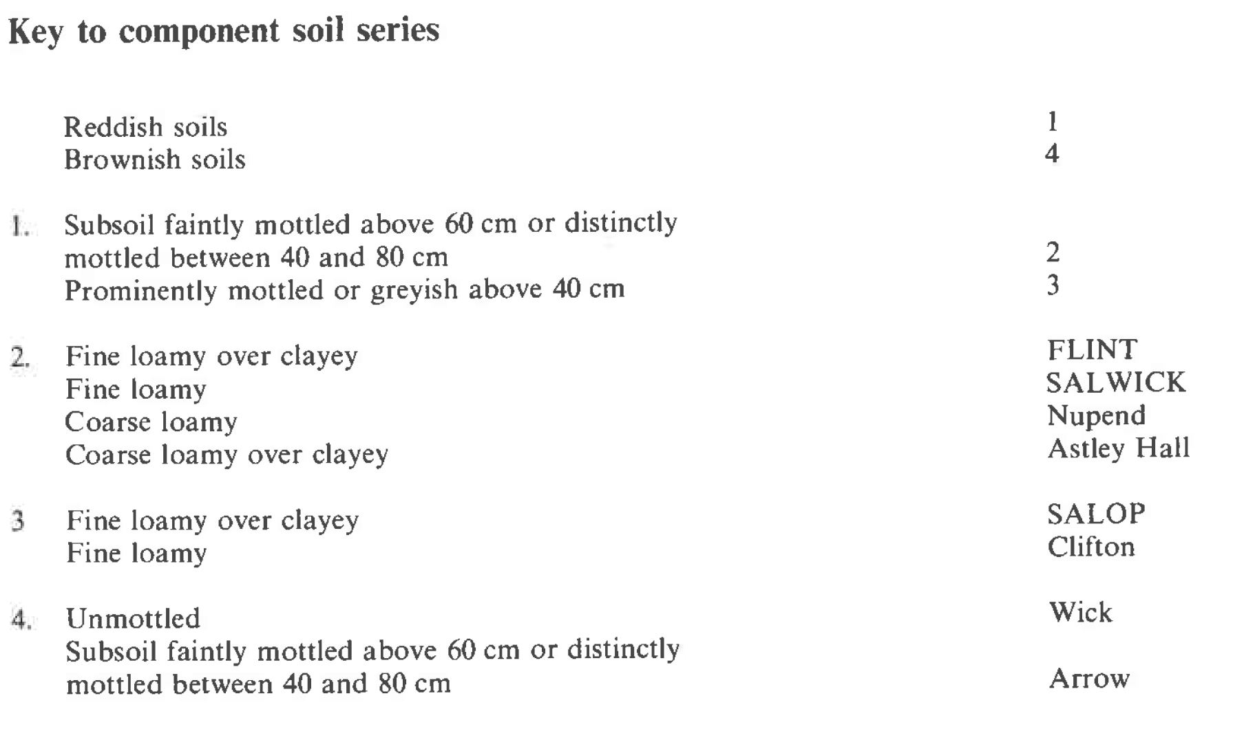 |
Northern Region
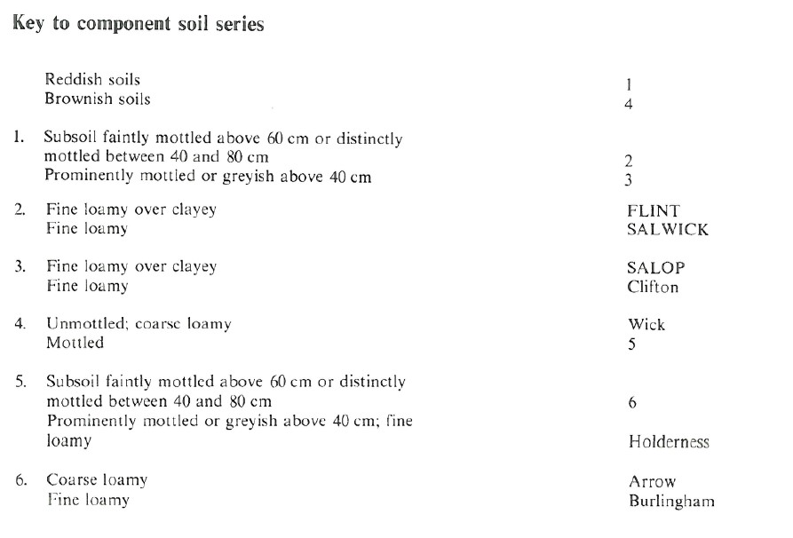 |
Wales
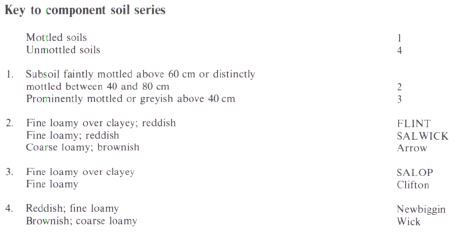 |
Typical Landscapes
Wales
 |
Midlands
 |
All information Copyright, Cranfield University © 2025
Citation: To use information from this web resource in your work, please cite this as follows:
Cranfield University 2025. The Soils Guide. Available: www.landis.org.uk. Cranfield University, UK. Last accessed 25/04/2025
