
Soil Associations
0572q ASHLEY
Soil and site characteristics
Fine loamy over clayey soils with slowly permeable subsoils and slight seasonal waterlogging associated with similar but wetter soils. Some calcareous and non-calcareous slowly permeable clayey soils.
Geology
Chalky till
Cropping and Land Use
Winter cereals and some short term grassland; some sugar beet in the Eastern Region.
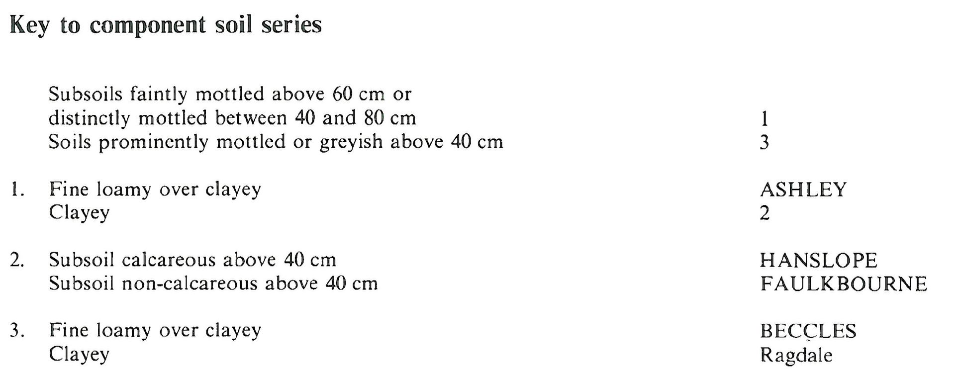
Component soil series
| Subgroup | Series name | Percentage | WRB 2006 link |
|---|---|---|---|
| 5.72 | ASHLEY | 55% | Endostagnic Luvisols |
| 4.11 | HANSLOPE | 10% | Calcaric Stagnic Cambisols |
| 7.11 | BECCLES | 10% | Eutric Albic Luvic Stagnosols |
| 4.31 | FAULKBOURNE | 10% | Clayic Stagnic Luvisols |
Covers 471 km2 in England and Wales
Soilscapes Classification
| 8 |
Slightly acid loamy and clayey soils with impeded drainage |
0572q ASHLEY
Detailed Description
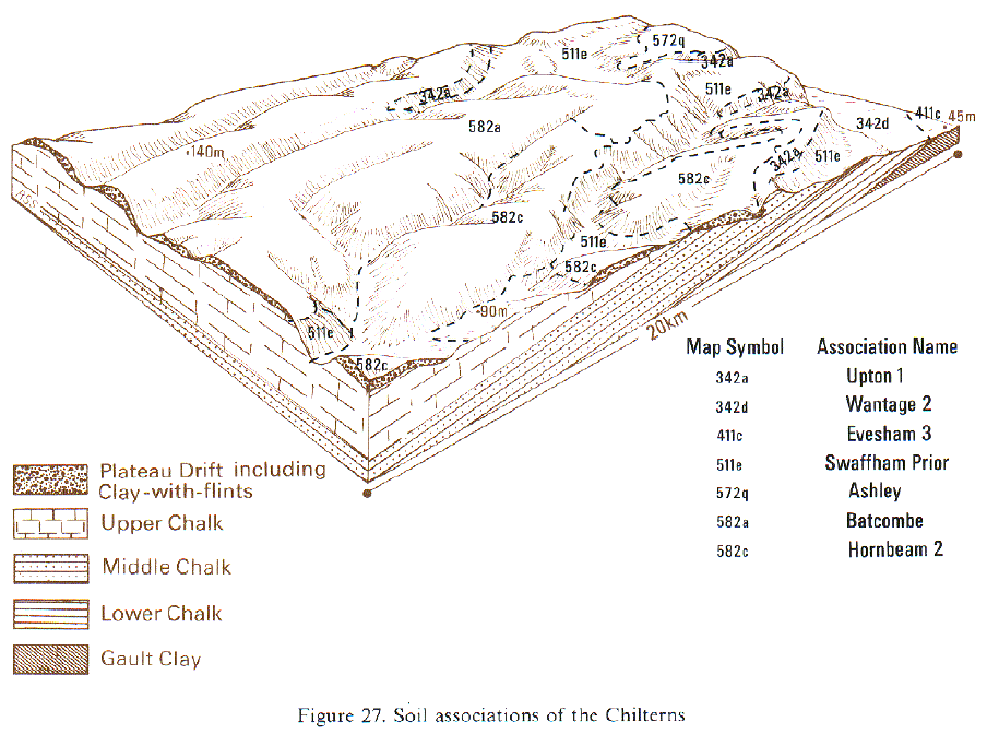
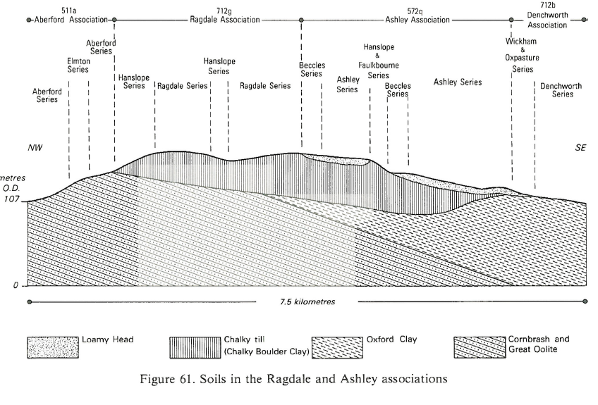
The Ashley association, covering some 456 km², is mainly found on chalky till in Eastern England (Hodge et al. 1984) but also covers small parts of the Midlands, South East and South West England. It consists predominantly of fine loamy over clayey stagnogleyic argillic brown earths of the Ashley series, where thin loamy drift covers the chalky till. Also included are calcareous pelosols belonging to the Hanslope series, and argillic pelosols of the Faulkbourne series on convex slopes where erosion has largely removed the upper fine loamy layers. Typical stagnogley soils, Beccles series, are locally common on receiving sites. In the Midlands this association covers only 40 km² on chalky till east of Leicester. It is well represented near Fleckney, Little Stretton and Gaddesby on gently undulating ground between 90 and 120 m O.D.
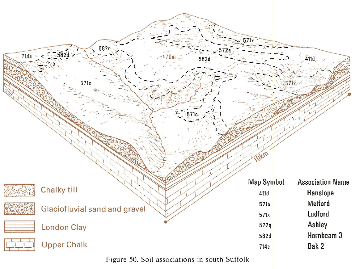
The association covers about 336 km² in Eastern England, mainly in mid-Suffolk between Bury St Edmunds and Ipswich, and along the flanks of the Dove valley near Eye. It is also extensive around Ampthill in Bedfordshire. There are about 60 km² near Northampton and small patches in Essex and Hertfordshire. The terrain is usually gently undulating and the slopes assist natural drainage. Beccles soils are confined to level and receiving sites, particularly in Northamptonshire, and Hanslope and Faulkbourne soils occur mainly on convex slopes. In mid-Suffolk, Ashley series covers most of the land, Beccles soils are rare but calcareous Cannamore and Eyeworth profiles are found.
In South West England the soils cover approximately 10 km² on a terrace-like feature along the Evenlode valley west of Moreton-in-Marsh, where the drift is rather variable. Ashley soils are predominant with Beccles soils confined to small concave receiving sites. The loamy Wick, Arrowand Bishampton series make up the principal inclusions. Oxpasture series occurs on loamy drift on concave slopes over Jurassic clay shales, usually near the margins of the till plateau.
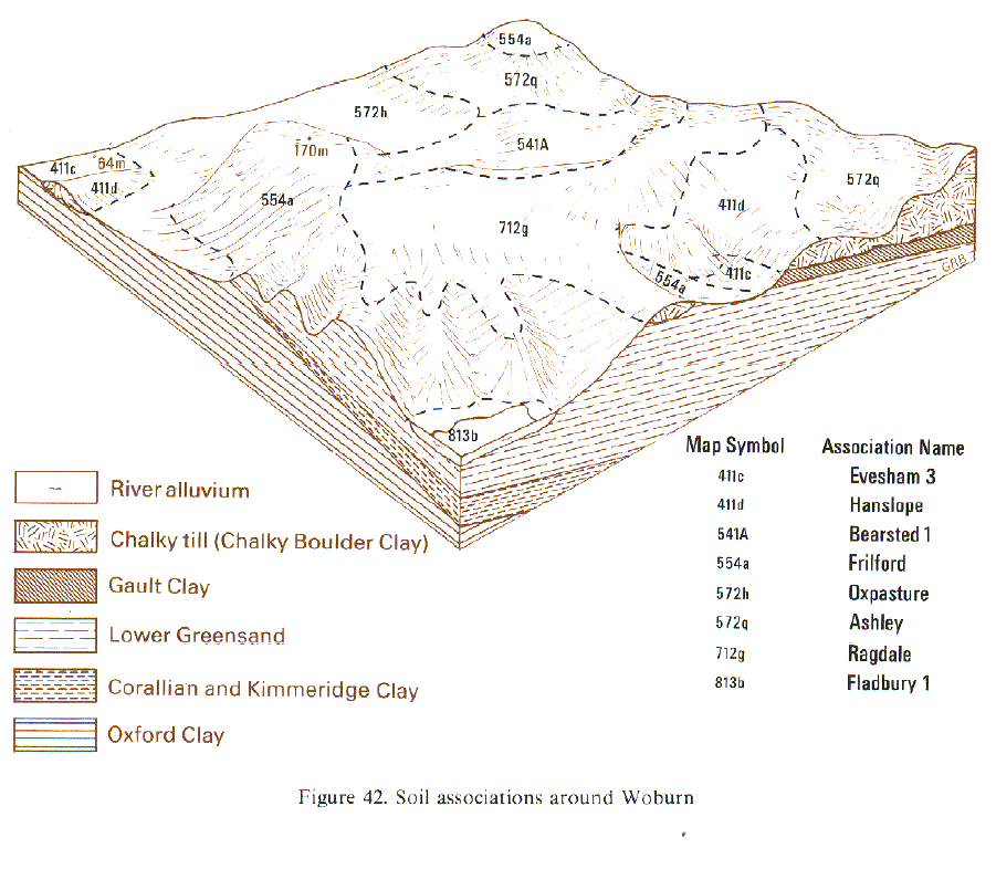
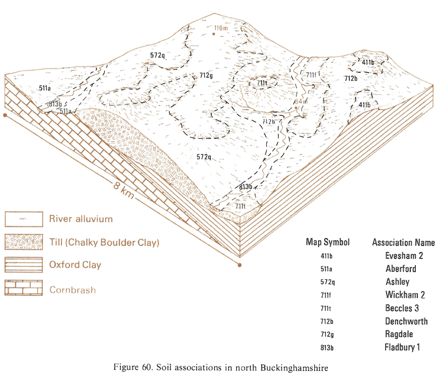
In South East England the association occurs between Brackley and Leighton Buzzard, mainly on level or gently undulating land. Ashley soils cover more than two-thirds of the land with Beccles soils on flat ground on the plateau, and Hanslope and Faulkbourne soils on the convex slopes of the valleys that dissect the till. The depth to chalky till varies and some Bishampton soils and Sutton soils are included around Stewkley where there is thick loamy drift which includes gravel. Ragdale soils have also been recorded on level ground.
Soil Water Regime
Most of the soils have slowly permeable subsoils and are seasonally waterlogged (Wetness Class III) when undrained, but they respond well to drainage and the soil water regime is readily improved. For instance, after tile drainage, Ashley soils are often only occasionally waterlogged (Wetness Class II). Large areas are level or gently sloping and, because the subsoils are slowly permeable, excess winter rainfall is only slowly accepted causing moderately rapid surface run-off, and on level sites standing water is common for short periods. In Eastern England the main Ashley soils are more permeable than the other soils and, with artificial drainage, are only occasionally waterlogged (Wetness Class II). In the west of the region, where the annual rainfall is more than 625 mm, seasonal waterlogging is prolonged and it is here that most of the Beccles soils occur. The soils are only slightly droughty for most crops in Bedfordshire and Northamptonshire, where the average annual rainfall is more than 600 mm, but in the east crops suffer from a moderate drought risk in normal seasons
Cropping and Land Use
The area under grass has been reduced in recent years and much land is now in continuous cultivation. Potatoes are grown locally although there is a risk of structural damage if the crop is harvested in wet conditions. There is an adequate period for autumn tillage and with the short period suitable for landwork in spring this favours autumn sowing. Profile available water is generally adequate for cereals, although in dry years there may be a loss of yield because of drought. The yield potential of grassland is moderate but the poaching risk restricts the grazing period, even on Ashley soils. The risk is greater on Beccles, Hanslope and Faulkbourne soils which have a larger retained water capacity and a shorter grazing season.
The soils are naturally acid in the plough layer although pH usually increases with depth and becomes alkaline within I m. There is little response to potassium fertilizer but small dressings are advisable for continuous cereal cropping. Phosphorus content is inherently low.
0572q ASHLEY
Distribution Map
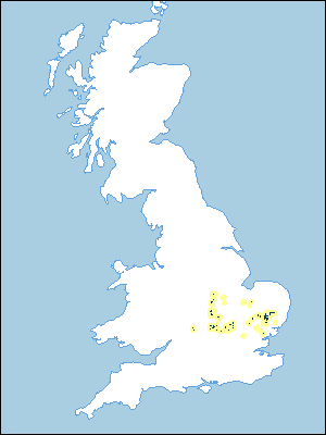 |
Note that the yellow shading represents a buffer to highlight the location of very small areas of the association.
Keys to component soil series
South Eastern Region
 |
Eastern Region
 |
Typical Landscapes
Eastern Region
 |
Eastern Region
 |
Eastern Region
 |
Eastern Region
 |
South Eastern Region
 |
South Eastern Region
 |
All information Copyright, Cranfield University © 2025
Citation: To use information from this web resource in your work, please cite this as follows:
Cranfield University 2025. The Soils Guide. Available: www.landis.org.uk. Cranfield University, UK. Last accessed 25/04/2025
