
Soil Associations
0581b SONNING 1
Soil and site characteristics
Well drained flinty coarse loamy and sandy soils, mainly over gravel. Some coarse loamy over clayey soils with slowly permeable subsoils and slight seasonal waterlogging.
Geology
Plateau gravel and river terrace drift
Cropping and Land Use
Dairying on short term grassland cereals; some horticultural crops and coniferous woodland; gravel extraction.
Component soil series
| Subgroup | Series name | Percentage | WRB 2006 link |
|---|---|---|---|
| 5.81 | SONNING | 40% | Chromic Endoskeletic Luvisols |
| 5.81 | BOCKMER | 20% | Ruptic Chromic Skeletic Luvisols |
| 5.54 | ST ALBANS | 10% | Chromic Skeletic Luvisols |
| 5.41 | HALL | 10% | Eutric Endoskeletic Cambisols |
| 5.82 | BERKHAMSTED | 10% | Abruptic Chromic Endostagnic Luvisols |
Covers 192 km2 in England and Wales
Soilscapes Classification
| 6 |
Freely draining slightly acid loamy soils |
0581b SONNING 1
Detailed Description
Stony coarse-textured, well drained soils formed in Plateau Gravel and river terrace drift are mapped in this association, which occurs south of Hitchin and near Watford in Hertfordshire. The drift deposits, which often rest at depth over the Chalk, consist of loamy or sandy flint gravels which have been disturbed and reworked by cryoturbation during Pleistocene times to give patterned ground. Locally aeolian silty drift is incorporated into the surface horizons so adding further to the complexity of the soil pattern.
Near Watford typical paleo-argillic brown earths of the Sonning series predominate with Berkhamsted series, stagnogleyic paleo-argillic brown earths, the most common associate. Deep coarse loamy Horseley soils with reddish and grey mottled subsoils, and fine loamy over clayey Marlow soils are locally common. St Albans series, argillic brown sands, and less stony sandy Ebstree and Hall soils, typical brown earths, are also found. The Plateau Gravel caps a ridge in the Hitchin gap where gravelly Bockmer soils are the most widespread. Fine loamy soils such as Marlow and Efford series are locally common, the latter often associated with deep, brownish coarse loamy Maplestead soils.
It also occurs in the Colne and Hiz valleys in Hertfordshire. The drift deposits, which often rest at depth over the Chalk, consist of loamy or sandy flint gravels which have been disturbed and reworked by freeze and thaw to give patterned ground. Locally aeolian silty drift is incorporated adding further to the complexity of the soil pattern. Most land is gently sloping.
West of Newbury, where the river gravels are overlain by flinty Head and patches of stoneless silty drift, Sonning soils are most frequent and Bockmer soils the main ancillary series. Here, Hook soils occur locally in patches of silty drift. Berkhamsted and occasional Hornbeam soils are present on rising ground. In the Thames valley, particularly around Marlow where the soils have been mapped in detail, Bockmer soils often predominate on level and gently sloping river terraces, and Sonning series is subordinate. Berkhamsted series and, locally, some Carstens soils occur on flat higher ground; small areas of Andover, Winchester and Frilsham soils are found on adjoining slopes and spurs. Sonning series predominates on Plateau Gravel around Shiplake, but near Sulham, soils of the Berkhamsted and St Albans series are also widespread. Some land near Reading was mapped as Sonning series or with Berkhamsted complex as then defined. Elsewhere in Berkshire, land previously mapped as Berkhamsted and Southampton associations is included.
In Hampshire, on high-level river terraces in the upper Test valley and in the Meon valley, Sonning and Bockmer soils are co-dominant. On the Isle of Wight, on river terraces at about 50 m O.D. flanking the Medina valley, Sonning and Bockmer series are dominant but some Hook soils are present in patches of silty drift over the gravel. Here, St Albans and Hall soils are rare. Near Newport, Berkhamsted soils are common.
Soil Water Regime
Sonning, Bockmer, St Albans and Hall series are all well drained (Wetness Class I). The clayey subsoils of Berkhamsted series are moderately permeable so these soils are occasionally waterlogged (Wetness Class II). Excess winter rain is readily absorbed and there is little surface run-off. In the South East Sonning and Hall soils have moderate reserves of available water and in average years are slightly droughty for cereals but moderately droughty for grass and potatoes. Bockmer and St Albans soils have less available water and production of all crops is limited by drought in most years.
Cropping and Land Use
Sonning and Hall soils have moderate reserves of available water and in average years are only slightly droughty for cereals but moderately droughty for grass and potatoes. Bockmer and St Albans soils have less available water and yields of all crops are limited by drought in most years. Although most of the main soils can be cultivated easily, stones cause implement wear, limit precision drilling and make the harvesting of root crops difficult. These limitations, with soil droughtiness and complex soil pattern, account for the restricted arable use. There is little risk of poaching on grassland but yields of grass are small and the stocking rate low.
In the South East much land is under grass, usually supporting dairy herds. Although Sonning, Bockmer, St Albans and Hall soils can be cultivated easily, stones cause implement wear, limit precision drilling and make the harvesting of root crops difficult. These limitations and soil droughtiness account for the small number of arable farms, although in the Marlow district much land is used for cereal growing and irrigated horticultural crops, the latter on lower slopes. There is little risk of poaching even in winter, but yields of grass are small and stocking rates are low. Berkhamsted soils suffer structural damage easily and in wet springs there may be few days suitable for tillage. Scattered remnants of once large, mainly deciduous, woodlands are widespread. Former hornbeam coppice is common and often has oak standards with subordinate beech, birch and ash. Some land is being worked for sand and gravel.
0581b SONNING 1
Distribution Map
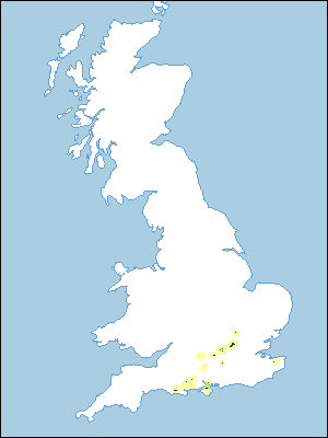 |
Note that the yellow shading represents a buffer to highlight the location of very small areas of the association.
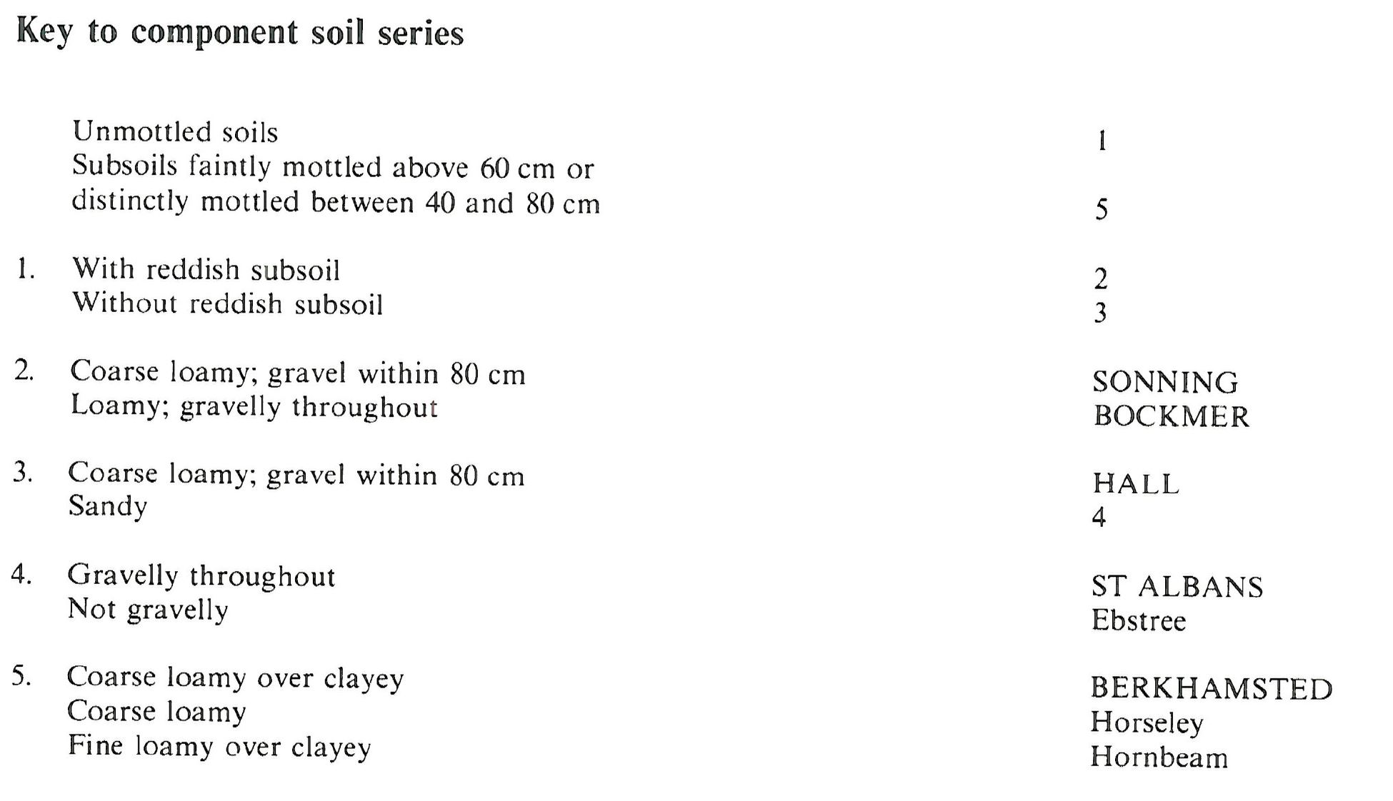
Keys to component soil series
South Eastern Region
 |
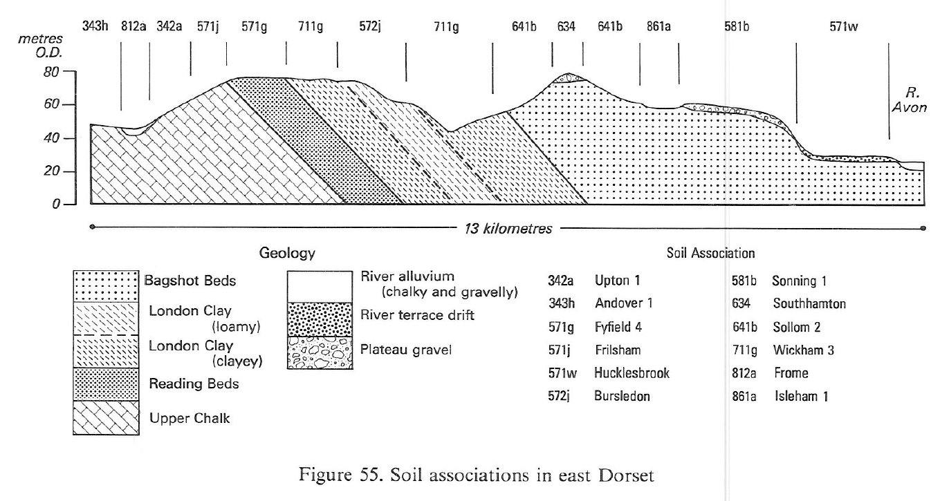
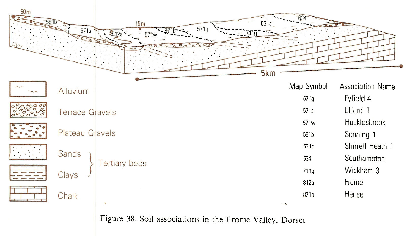
Typical Landscapes
South Western Region
 |
South Western Region
 |
South Eastern Region
 |
All information Copyright, Cranfield University © 2024
Citation: To use information from this web resource in your work, please cite this as follows:
Cranfield University 2024. The Soils Guide. Available: www.landis.org.uk. Cranfield University, UK. Last accessed 26/04/2024
