
Soil Associations
0631e GOLDSTONE
Soil and site characteristics
Well drained very acid very stony sandy soils with a bleached subsurface horizon, over conglomerate. Associated with less acid and less stony coarse loamy soils over sandstone.
Geology
Permo-Triassic and Devonian reddish conglomerate and sandstone
Cropping and Land Use
Coniferous woodland and dry lowland heath habitats; recreation.
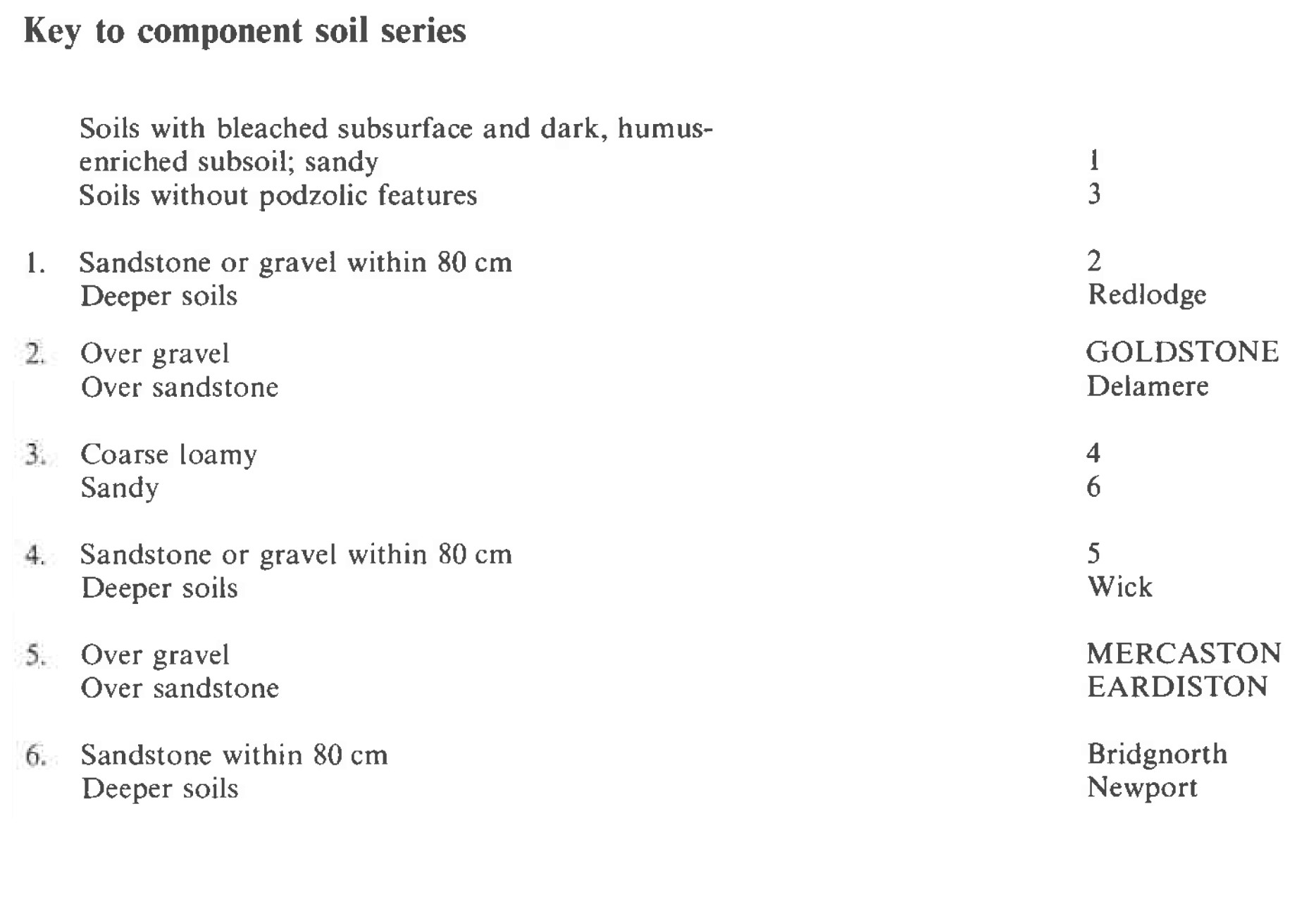
Component soil series
| Subgroup | Series name | Percentage | WRB 2006 link |
|---|---|---|---|
| 6.31 | GOLDSTONE | 30% | Episkeletic Albic Podzols |
| 5.41 | MERCASTON | 25% | Dystric Chromic Skeletic Cambisols |
| 5.41 | EARDISTON | 15% | Eutric Chromic Endoleptic Cambisols |
Covers 124 km2 in England and Wales
Soilscapes Classification
| 14 |
Freely draining very acid sandy and loamy soils |
0631e GOLDSTONE
Detailed Description
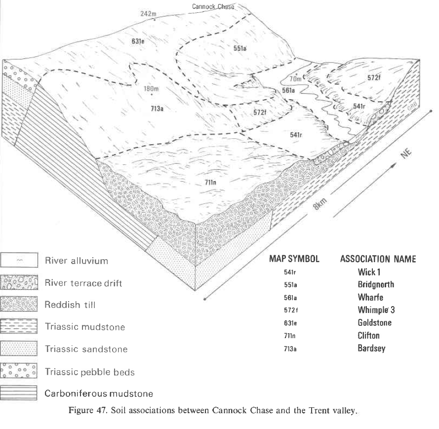
This association of very acid very stony sandy and coarse loamy soils is developed on reddish Permo-Triassic and Devonian conglomerates and pebbly sandstones. It is most extensive in the Midlands and South West England but it is also mapped in Wales. The hardness of the underlying rocks makes them resistant to erosion and they form distinctive flat-topped hills with mainly moderate or steep slopes. The dominant soils belong to the Goldstone series, humo-ferric podzols, with extremely porous gravelly profiles over hard conglomerate. The stones, which occupy over one-third of the soil volume, are mostly medium rounded quartzes and quartzites, though there are a few igneous pebbles. The main subsidiary soils are similarly stony but belong to the Mercaston series. These are typical brown earths developed in extremely permeable very stony reddish coarse loamy Head derived from conglomerate. Sandstone occurs within 80 cm of the surface locally and gives reddish coarse loamy soils of the Eardiston series and sandy soils of the Bridgnorth and Delamere series. The Redlodge and Wick series occur where there is thick drift. These soils are confined mostly to Staffordshire but extend in a narrow strip over the border into Worcestershire. Small areas occur in north-east Shropshire and near Walsall. They are most extensive on Cannock Chase on the conglomerate of the Triassic Pebble Beds. Here the Goldstone series is dominant under the extensive woodlands and heath but where there is sandy and coarse loamy drift, Redlodge, Wick and occasionally Newport soils are found. Sandstone beds are common within the conglomerate and these support Eardiston and Bridgnorth soils which are more stony than usual. The Mercaston series is restricted to the fringes of the Chase below 200 m O.D. where some ground has been cleared for agriculture. The Maer Hills, also under heath or woodland, are dominated by humo-ferric podzols of the Goldstone and Delamere series with Redlodge soils on thick drift. Land cleared for agriculture adjacent to the heath supports Bridgnorth soils. In contrast, Mercaston soils predominate north of Stone and around Moddershall where the land is mainly in agriculture. Bridgnorth and Eardiston series are the main associate soils. On agricultural land south-west of Loggerheads the association comprises Mercaston, Eardiston and Wick soils. Between Caverswall and Cheadle and in south Staffordshire, Mercaston and Eardiston soils cap flat-topped hills with subsidiary Bridgnorth and Goldstone soils. Stony Arrow soils occur in depressions. Around Oakamoor, Swynnerton Old Park and Cheadle Common, the land is mainly forested with Goldstone the dominant soil and Delamere and Mercaston series common.
In east Devon, the association covers 20 km² on a ridge extending northward from the coast at Budleigh Salterton. This feature, much of which is heathland, has a short west-facing scarp with a long and gentle easterly dipslope, in places broken by shallow steep-sided valleys. The soils over the Budleigh Salterton Pebble Beds are loamy and gravelly containing hard rounded pebbles of quartzite and are developed in Head derived from the underlying conglomerate. The soils include hums ferric podzols of the Goldstone series, humus ironpan stagnopodzols described as Budleigh series and typical brown earths, the Mercaston series. On common land Goldstone and Budleigh series have thin dark organic-rich surface horizons over bleached subsurface horizons of loose loamy sand. Deposition of humus occurs lower down the profile. The Goldstone series is rapidly permeable and below the bleached layer there is an iron-rich horizon of very stony sandy loam. In the Budleigh series a mottled and bleached horizon overlies a discontinuous ironpan, the mottling indicative of slow permeability above an indurated substratum. On farmed land the well drained Mercaston series has weakly differentiated horizons of reddish brown very stony sandy loam or sandy silt loam.
Soil Water Regime
The well drained (Wetness Class I) extremely porous soils readily absorb winter rainfall, even on steep slopes. There is less water available to crops in the very stony Mercaston and Goldstone than in the associated Eardiston soils.
Cropping and Land Use
More than half the land is woodland or semi-natural heath. The rest is mostly grassland, though cereals are sometimes grown. The trees are mainly conifers or in places planted in mixed stands and the heath is dominated by heather. The largest plantations, on Cannock Chase, are managed by the Forestry Commission. Scots and Corsican pine are the main species but European and hybrid larch are common. In some parts Red oak is planted with a coniferous nurse crop but birch trees flourish on the fringes of the woodland. Growth is good despite the very coarse and stony nature of the soils. The higher ground of the Chase is under dry boreal heather moor dominated by heather with subsidiary bilberry and wavy hair-grass; Ratcliffe (1977) describes this and other local vegetation types in some detail. The Forestry Commission plantations around Oakamoor, Swynnerton Old Park and Cheadle Common are dominated by Scots pine and larch with some Corsican pine. Slopes are mostly moderate to steep but where they are gentle, oak, birch and occasional beech woodlands are found. Bracken so flourishes on slopes, that it excludes other ground flora. Much of Kinver Edge and the Maer Hills is covered by woodland interspersed with dry boreal Calluna heaths, infested to varying degrees with bracken. Elsewhere the land is cropped for grass with some cereals and, though stones cause wear to implements, it is easily cultivated. The size and shape of the stones, however, makes potato harvesting difficult. Reserves of available water are small but as much of the land occurs in moist districts this is not a serious deficiency. Organic matter contents fall rapidly under continuous arable use. Large applications of lime and fertilizers are needed during reclamation and regular applications are required thereafter to prevent impoverishment because soluble nutrients are easily removed by leaching.
0631e GOLDSTONE
Distribution Map
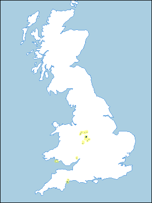 |
Note that the yellow shading represents a buffer to highlight the location of very small areas of the association.
Keys to component soil series
Midlands
 |
Typical Landscapes
Midlands
 |
All information Copyright, Cranfield University © 2025
Citation: To use information from this web resource in your work, please cite this as follows:
Cranfield University 2025. The Soils Guide. Available: www.landis.org.uk. Cranfield University, UK. Last accessed 25/04/2025
