Soil Associations
0631f Crannymoor
Soil and site characteristics
Well drained sandy soils mostly under woodland and very acid with a bleached subsurface horizon. Associated with sandy soils affected by groundwater.
Geology
Glaciofluvial drift
Cropping and Land Use
Coniferous woodland and dry lowland heath habitats; recreation; some cereals.
Component soil series
| Subgroup | Series name | Percentage | WRB 2006 link |
|---|---|---|---|
| 6.31 | CRANNYMOOR | 38% | Albic Podzols |
| 5.51 | NEWPORT | 24% | Dystric Arenosols |
| 6.41 | SOLLOM | 12% | Endogleyic Albic Carbic Podzols |
| 8.21 | BLACKWOOD | 11% | Arenic Mollic Gleysols |
Covers 152 km2 in England and Wales
Soilscapes Classification
| 14 |
Freely draining very acid sandy and loamy soils |
0631f Crannymoor
Detailed Description
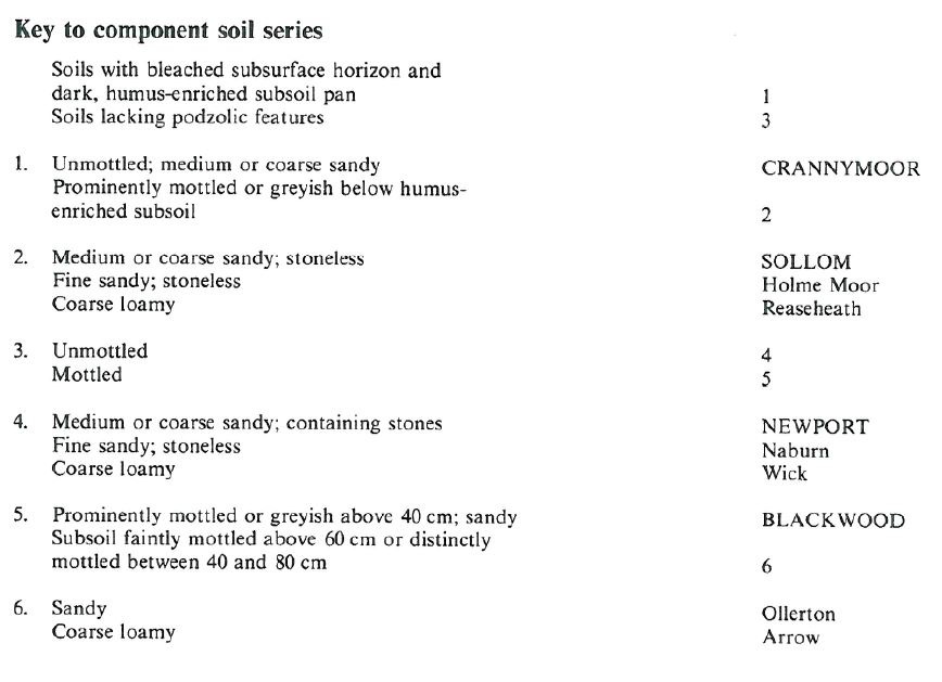
The Crannymoor association consists mainly of very acid well drained sandy podzols, mostly under woodland or old heathland, and other sandy soils, some affected by fluctuating groundwater levels. It occurs on glaciofluvial sands and gravels which form gently undulating or hummocky ground in Cumbria, Cheshire, Lancashire, Cleveland, Humberside and Lincolnshire. The most extensive soils are stoneless medium or coarse sandy humo-ferric podzols, the Crannymoor series. Typical profiles have a bleached subsurface layer with uncoated mineral particles and a prominent dark humose horizon or pan over an iron-enriched subsoil. Where cultivated, at least part of the bleached subsurface horizon becomes incorporated in the plough layer. Subsidiary soils include typical brown sands, the Newport series, typical sandy gley soils, the Blackwood series and the Sollom series, typical gley podzols. Sollom soils are distinguished from the Crannymoor series by the absence of a distinct iron-enriched horizon and the presence of seasonally waterlogged sand below a prominent humose horizon. Podzols predominate in woodland and heath, brown sands and sandy gley soils being more common on arable land where the pan has been broken by cultivation. South of Scunthorpe, near the villages of Scotter and Scotton, coarse loamy soils of Reaseheathand Wick series are present locally, as are sandy profiles of the Ollerton series. On Scotter Common fine sandy soils of the Naburn and Holme Moor series also occur.
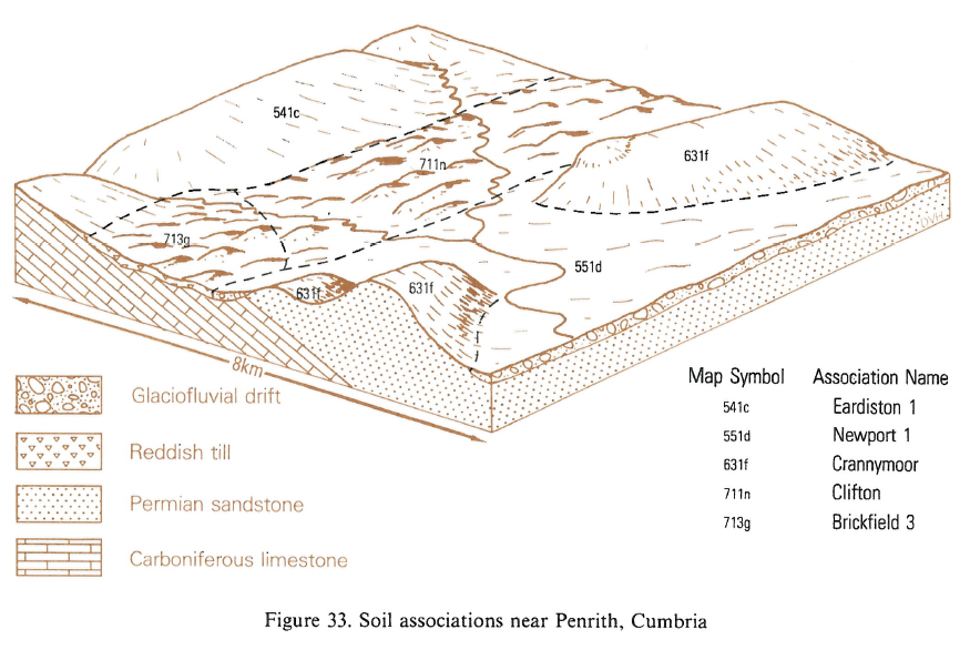
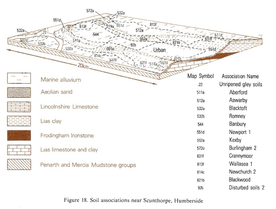
The association covers 61 km² and the soil pattern is generally simple. Podzols predominate in woodland and heath, brown sands and sandy gley soils being more common on arable land where the pan has been broken by cultivation. In plantations near Broughton, east of Scunthorpe, there are occasional coarse loamy Reaseheath and Wick soils, with sandy Ollerton soils. Further south, near Messingham, there are also fine sandy Naburn and Holme Moor soils. In Cleveland and the Vale of Eden, Wick and Arrow soils are important. The position of the association in the landscape in relation to other soils is illustrated for the Scunthorpe district and the Penrith district.
Soil Water Regime
Soils of the Crannymoor and Newport series are well drained (Wetness Class I), whilst both the Blackwood and Sollom series, where undrained, are waterlogged in winter for long periods (Wetness Class IV). Crannymoor and Newport soils are slightly or moderately droughty for most arable crops and very droughty for grass. Blackwood and Sollom soils, are generally less droughty, but, where drainage has lowered the groundwater level, the soils are slightly or moderately droughty.
Cropping and Land Use
The soils are acid under natural conditions. Inherent fertility is poor, potassium being especially deficient, and manganese and boron deficiencies may be induced by over liming. With well-judged use of fertilizer, good yields can be obtained if crops are irrigated in early summer. Much of the land, however, is under coniferous or mixed woodland. Inglewood Forest, near Penrith, is mainly of Scots pine, Japanese larch and Douglas fir. The land is generally too dry for Sitka spruce although some has been planted and yields poorly. Elsewhere the land is in arable with wheat, barley, potatoes and, within range of processing factories, sugar beet as the principal crops. The soils are easy to work and there is adequate opportunity in both autumn and spring for necessary landwork. Droughtiness is the main limitation to crop growth. Sand and gravel are quarried near Messingham, Humberside, where workings are small and restoration difficult. It is desirable that future workings be restored to productive agriculture or forestry.
0631f Crannymoor
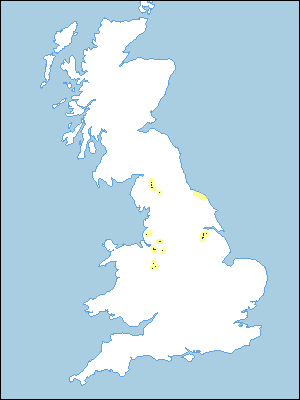
Distribution Map
 |
Note that the yellow shading represents a buffer to highlight the location of very small areas of the association.
Keys to component soil series
Northern Region
 |
Typical Landscapes
Northern Region
 |
Northern Region
 |
All information Copyright, Cranfield University © 2025
Citation: To use information from this web resource in your work, please cite this as follows:
Cranfield University 2025. The Soils Guide. Available: www.landis.org.uk. Cranfield University, UK. Last accessed 25/04/2025
