
Soil Associations
0641a SOLLOM 1
Soil and site characteristics
Deep often stoneless humose sandy soils, with bleached subsurface horizon affected by groundwater. Very acid where uncultivated. Where cultivated groundwater controlled by ditches. Naturally well drained very acid sandy soils in places.
Geology
Glaciofiuvial drift
Cropping and Land Use
Cereals, potatoes, field vegetables and horticultural crops; some short term grassland.
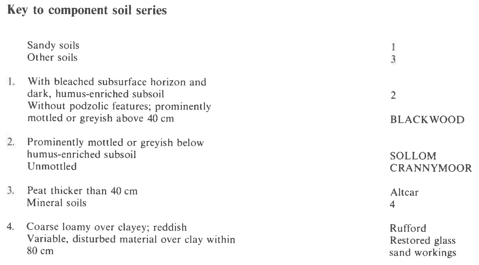
Component soil series
| Subgroup | Series name | Percentage | WRB 2006 link |
|---|---|---|---|
| 6.41 | SOLLOM | 50% | Endogleyic Albic Carbic Podzols |
| 6.31 | CRANNYMOOR | 30% | Albic Podzols |
| 8.21 | BLACKWOOD | 15% | Arenic Mollic Gleysols |
Covers 228 km2 in England and Wales
Soilscapes Classification
| 15 |
Naturally wet very acid sandy and loamy soils |
0641a SOLLOM 1
Detailed Description
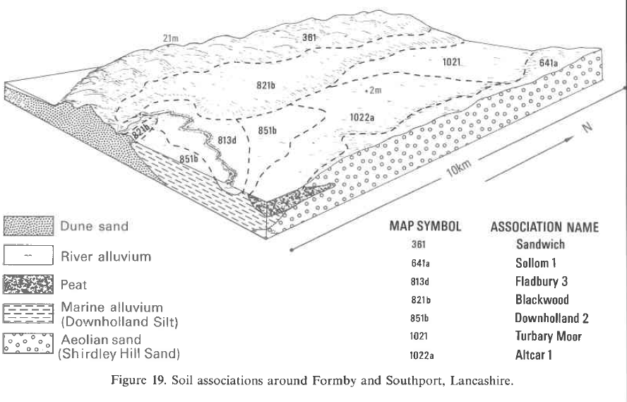
The association is dominated by gley-podzols and podzols developed in glaciofluvial sand. It covers 150 km² of the Lancashire coastal plain between the Mersey and the Ribble, on flat or gently undulating land between 7 and 60 m O.D. The dominant Sollom series, typical gley-podzols, with stoneless sand to more than 80 cm depth occupies about half the land. The stoneless sandy Crannymoor series, humo-ferric podzols, and the Blackwood series, typical sandy gley soils, each account for one-quarter. Large areas were formerly covered by peat, which has wasted since the lowering of the water-table as a result of arterial drainage. Topsoils are still humose or peaty, adjacent to peaty soils of the Altcar and Turbary Moor associations, near the coast. In the Ormskirk district the association is found on the Shirdley Hill Sand. Crannymoor soils are on low hillocks, with Sollom and Blackwood soils on the surrounding broad expanses of flat land. South of Newton-le-Willow and north of Halewood the association is on the glaciofluvial sand and gravel terraces of the Mersey tributaries. Fine loamy or clayey till underlies all soils of this association at less than 120 cm depth. The diversity of soil profiles within short distances may be attributed to the interaction of varying groundwater levels with varying thicknesses of sand over till. The Shirdley Hill Sand is an important raw material for the Lancashire glass industry. The topsoil is stripped and stored for restoration and the underlying grey or white leached layer of almost pure silica sand, ranging in thickness from 15 to 90 cm, is removed for glass making. A tile drainage system is then installed in the upper layers of the underlying till, the topsoil replaced and the land restored to agriculture. The restored soil is similar to the Rufford series, since the till now lies within only 45 to 60 cm of the surface. Such areas have been included within the Sollom asociation but some were distinguished separately by Hall and Folland (1970).
Soil Water Regime
Sollom and Blackwood soils are seasonally waterlogged when undrained (Wetness Class III and IV), but with tile drainage and deep ditching, the soils are mostly well drained (Wetness Class I) like the Crannymoor soils. Surplus winter rainwater passes easily downwards through the upper layers of all the soils. Water collects above the till and forms a moisture reserve for arable crops during the summer months. The soils are not droughty for most crops, but grass shows moderate effects on Crannymoor soils during most summers, and on Sollom and Blackwood soils in dry summers, because of their small available water capacity. Irrigation is needed, however, particularly for potatoes when they are bulking up.
Cropping and Land Use
The soils are intensively farmed, cereals, root crops and brassicas being the main crops. Rotations include wheat, barley, potatoes, sugar beet, peas, broccoli, cabbage and various salad crops. The soils are very easily worked and in most years a satisfactory tilth can be formed in both autumn and spring, but spring landwork is not advised in wet years. Soil structure, which is naturally weak in the coarse surface layers, can be damaged by badly timed cultivations or by heavy rain. Also, in spring before crop cover is complete, some of the soils are liable to wind blow because of their unstable surface structure. Short-term leys provide a break which improves topsoil stability by increasing the organic matter content. The soils are inherently infertile and acid so that heavy dressings of lime and fertilizer are required, although phosphorus levels are generally satisfactory. Over-liming, however can cause minor element deficiencies, those of magnesium, manganese and boron being the most serious.
0641a SOLLOM 1
Distribution Map
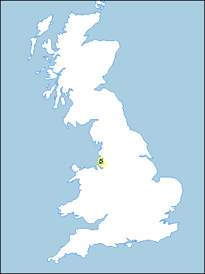 |
Note that the yellow shading represents a buffer to highlight the location of very small areas of the association.
Keys to component soil series
Midlands
 |
Typical Landscapes
Midlands
 |
All information Copyright, Cranfield University © 2025
Citation: To use information from this web resource in your work, please cite this as follows:
Cranfield University 2025. The Soils Guide. Available: www.landis.org.uk. Cranfield University, UK. Last accessed 25/04/2025
