
Soil Associations
0641b Sollom 2
Soil and site characteristics
Deep often stoneless and very acid, humose sandy soils with bleached subsurface horizon, affected by groundwater. Well drained very acid sandy soils on slopes. Some sandy over fine loamy soils with slowly permeable subsoils and slight seasonal waterlogging.
Geology
Tertiary sand
Cropping and Land Use
Wet lowland heath habitats, coniferous woodland; recreation; military use; some improved grassland and horticultural crops.
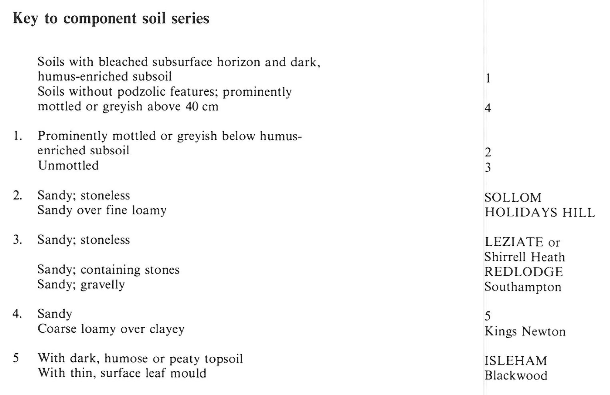
Component soil series
| Subgroup | Series name | Percentage | WRB 2006 link |
|---|---|---|---|
| 6.41 | SOLLOM | 30% | Endogleyic Albic Carbic Podzols |
| 6.32 | LEZIATE | 20% | Albic Carbic Podzols |
| 6.43 | HOLIDAYS HILL | 15% | Ruptic Stagnic Albic Carbic Podzols |
| 8.61 | ISLEHAM | 15% | Arenic Mollic Gleysols |
| 6.31 | REDLODGE | 10% | Albic Podzols |
Covers 242 km2 in England and Wales
Soilscapes Classification
| 15 |
Naturally wet very acid sandy and loamy soils |
0641b Sollom 2
Detailed Description
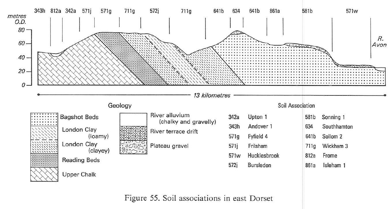
The Sollom association includes soils on sandy Bagshot Beds in Dorset and west Hampshire, with a small occurrence at Alderbury in Wiltshire. Deep, acid, seasonally waterlogged Sollom soils, typical gley podzols, are found on gentle slopes in sandy and coarse loamy drift. Well drained sandy humus podzols of the Leziate series, together with Shirrell Heath and Redlodge soils, humo-ferric podzols, occupy more sloping ground, accompanied by sandy over fine loamy stagnogley-podzols of the Holidays Hill series. Acid raw oligo-amorphous peat soils of the Crowdy series and sandy Isleham soils are common in shallow valleys and around springs. Plateau Gravels on hilltops and ridge crests carry well drained flinty Southampton soils. Thin flinty, loamy drifts over clay are occasionally found giving seasonally waterlogged coarse loamy over clayey Kings Newton soils and fine loamy over clayey Wickham soils. The proportions of associate soils vary greatly from place to place. In the more dissectea higher parts of Wareham Forest, well drained sandy podzols are extensive. On the Purbeck Heaths, clay layers are common in the Bagshot Beds, giving rise to Holidays Hill soils and associated stagnogley soils. Gentle footslopes and other flat, low-lying ground in parts of Ringwood Forest, West Moors and Ferndown Forest has a high groundwater table with Sollom, Isleham and Blackwood soils. Everywhere the variability of the underlying lithology gives rise to complicated soil patterns.
The podzols all have dark, often humose, topsoils overlying grey strongly leached subsurface layers, below which are dark coloured accumulations of organic matter with or without accompanying iron compounds. Permeable, unmottled yellowish, brownish or reddish sandy or loamy subsoils characterize the well drained podzols of the Leziate, Shirrell Heath, Redlodge and Southampton series. The gley podzols have either permeable, mottled sandy or loamy subsoils with high groundwater like the Sollom series, or slowly permeable mottled clays and loams as in Holidays Hill soils. The gley soils lack subsoil accumulations of organic matter or iron compounds and have either slowly permeable clay subsoils, for example Wickham and Kings Newton series, or permeable sandy subsoils affected by groundwater, Isleham and Blackwood series.
Sollom 2 occurs in South East England in Ringwood Forest and near Ripley in Hampshire. In Ringwood Forest, Sollom soils are found on low-lying ground with some Isleham and Blackwood soils around spring seepages and streams. Clay layers within the Bagshot Beds can give occasional Holidays Hill soils. On slopes, well drained sandy Leziate or Crannymoor soils are found whereas small gravel-capped ridges give Southampton soils. Near Ripley, Sollom, Isleham and Blackwood soils are developed in low-lying sandy drift over terrace gravels and Wickham and Kings Newton soils where thin stony loamy drift covers Tertiary clay.
Soil Water Regime
Sollom and Isleham soils are waterlogged by groundwater for much of the year (Wetness Class V) whereas Leziate, Shirrell Heath and Redlodge soils are rarely wet (Wetness Class I). The latter soils have little water available for plant growth and as a consequence are very droughty and readily absorb winter rain.
Cropping and Land Use
The land is of only limited value for agriculture because of soil acidity, soil wetness and droughtiness, although some has been reclaimed from heath and provides poor-quality grazing. There are some market gardens around Poole and Bournemouth, mainly on the better drained soils. As well as careful correction of acidity to avoid trace element problems, the soils need frequent applications of fertilizers, to replace the nutrients regularly lost by leaching. Until the beginning of this century most of the land was heathland and bog but it is now extensively afforested with conifers, principally Corsican and Scots pines. Forestry has had mixed success, early plantings of pine suffered seriously from both waterlogging and poor nutrient availabilty, especially that of phosphorus. In recent years, trials with Bishop and Radiata pines have produced good results, especially on the drier soils. On the low lying ground it is difficult to achieve standards of drainage necessary for good tree growth and much of this land is ideal for wetland conservation.
The most extensive remaining heaths are on the southern fringes of Poole Harbour and on the Lulworth Ranges where there are nature reserves representative of acid lowland habitats. These heathlands carry the Dorset Heath (Erica ciliaris) birds like the Dartford Warbler and the Hobby. The Smooth Snake and Sand Lizard, rare reptiles, are found on the drier heathland and the habitat is also entomologically important. Both the forests and heaths provide recreational facilities and large tracts are used as army ranges. Ball clay is mined and dug from the Bagshot Beds to the south of Wareham where past mining activity has left some industrial dereliction.
0641b Sollom 2
Distribution Map
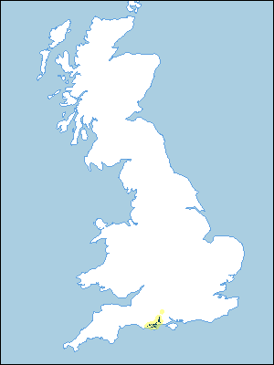 |
Note that the yellow shading represents a buffer to highlight the location of very small areas of the association.
Keys to component soil series
South Western Region
 |
Typical Landscapes
South Western Region
 |
South Western Region
 |
All information Copyright, Cranfield University © 2025
Citation: To use information from this web resource in your work, please cite this as follows:
Cranfield University 2025. The Soils Guide. Available: www.landis.org.uk. Cranfield University, UK. Last accessed 25/04/2025
