
Soil Associations
0711a STANWAY
Soil and site characteristics
Slowly permeable seasonally waterlogged often stoneless fine silty or fine silty over clayey soils on rock. Some silty soils, with slowly permeable subsoil and slight seasonal waterlogging.
Geology
Palaeozoic siltstone shale and mudstone
Cropping and Land Use
Permanent grassland with dairying and stock rearing; some winter cereals.
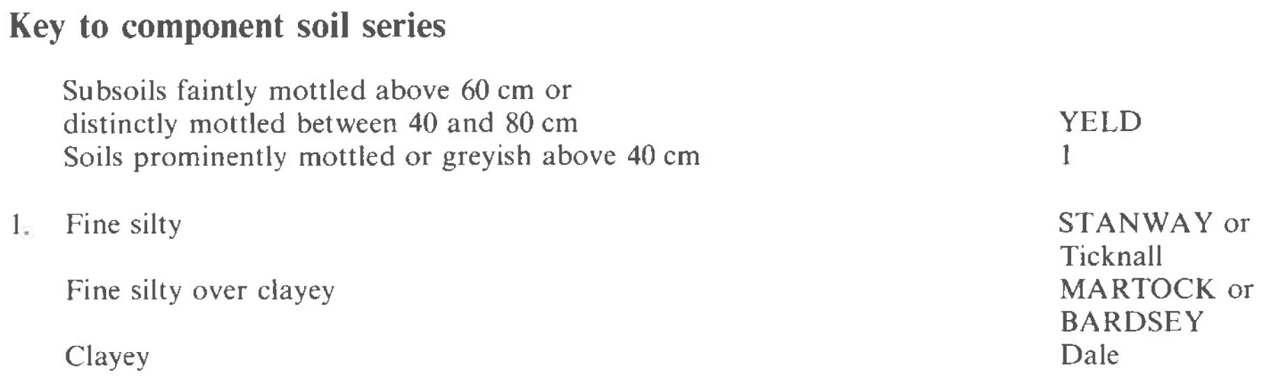
Component soil series
| Subgroup | Series name | Percentage | WRB 2006 link |
|---|---|---|---|
| 7.11 | STANWAY | 35% | Eutric Albic Luvic Stagnosols |
| 7.11 | MARTOCK | 30% | Eutric Albic Luvic Stagnosols |
| 5.72 | YELD | 20% | Endostagnic Luvisols |
| 7.13 | BARDSEY | 15% | Eutric Planosols |
Covers 126 km2 in England and Wales
Soilscapes Classification
| 17 |
Slowly permeable seasonally wet acid loamy and clayey soils |
0711a STANWAY
Detailed Description
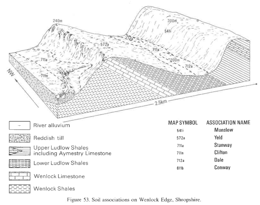
The Stanway association consists of slowly permeable, seasonally waterlogged fine silty soils developed over soft shales and siltstones. It is confined to the Lower Palaeozoic rocks of Shropshire and the Silurian inliers of May Hill, the Woolhope Dome and Malvern Hills, covering some 118 km². Near Shelve in western Shropshire and Ledbury in southern Worcestershire, the association extends into Powys and Gloucestershire. The easily eroded parent rocks give moderate to gentle valley slopes at heights from about 75 m O.D. near Alfrick to 305 m O.D. in the Shelve area, but most of the land lies between 150 and 230 m O.D. The association is dominated by fine silty, typical stagnogley soils of the Stanway series and similar but fine silty over clayey soils of the Martock series. Stanway soils are most common, but both series are closely interrelated and often difficult to separate. Most footslopes have a thin veneer of local Head, though this is usually silty and almost indistinguishable from the underlying shales and siltstones. Fine loamy patches occur downslope from local outcrops of fine-grained sandstones or igneous rocks. Here soils similar to the Stanway series but with fine loamy upper horizons (Palmer 1976) are found, along with the Bardsey series, a fine loamy over clayey stagnogley soil. Fine silty stagnogleyic argillic brown earths of the Yeld series occur on moderate to steep slopes, but are less mottled than other soils in the association. The soils vary widely in base status, ranging from neutral to moderately acid according to the nature of the parent rocks. Calcareous shales and siltstones are common within the Silurian strata giving relatively base-rich profiles. Where limestones occur within or upslope of the association, flushes of base-rich soil water have produced patches of dominantly neutral soils. Elsewhere, however, non-calcareous rocks predominate and more acid soils are developed. West of the Malvern Hills and in the Woolhope Dome, the Vale of Wigmore and Hope Dale, there are occasional clayey profiles of the Dale series formerly mapped as Speller series by Hodgson (1972). These are developed over soft shales and mudstones, usually in the lowest parts of the landscape. On Silurian strata, small inclusions of freely drained fine silty Barton soils and fine loamy Wilderhope soils are found on low ridges and benches formed by hard siltstones or earthy limestones. Prominently mottled fine silty over clayey Prolleymoor soils occur on patches of local drift in the Shelve.
Soil Water Regime
Subsoils in the association are slowly permeable and impede the downward percolation of excess surface water causing periodic waterlogging in upper horizons. Stanway, Martock and Bardsey soils are all seasonally waterlogged for prolonged periods (Wetness Class IV), but Yeld soils which are developed on moderate or steep slopes shed much of their excess water by surface run-off and are seasonally waterlogged for shorter periods (Wetness Class III). When Stanway, Martock and Bardsey soils are artificially drained, the duration of surface waterlogging is signficantly reduced (Wetness Class III) in all but the wettest areas around Shelve. Drainage measures on Yeld soils are often related to local spring seepage and when drained some of them are only occasionally waterlogged (Wetness Class II). Because there is much gently or moderately sloping land and lower subsoils are slowly permeable, most soil water moves laterally through topsoils and upper subsoils. Generally the association sheds excess winter rain rapidly.
Cropping and Land Use
The association is mainly under grassland and woodland, but some cereals are grown, particularly in Hope Dale and around the Vale of Wigmore. Grassland is used mainly for stock rearing, predominantly sheep, whereas dairying is confined mostly to the valleys in the Woolhope Dome. Where the land is used for intensive cattle rearing or dairying, careful management is needed to avoid poaching or damage by farm machinery. The large amounts of water retained in the fine silty topsoils and the frequent occurrence of subsoil waterlogging make soils poach easily. The risk is most severe in the wet districts around Shelve and in Hope Dale where organic matter contents of topsoils are greatest. With careful management however, good grass yields are possible, although some of the growth early and late in the season cannot be fully used. In south and east Herefordshire growth is sometimes checked during dry spells in the summer. Woodland occurs mainly on the steepest slopes, around the Vale of Wigmore and on upslope fringes in the Woolhope Dome, Malvern Hills and Hope Dale. A moist oak-hazel community is the typical semi-natural vegetation but oak-ash woodland with a ground layer including calcicoles occurs on base-rich sites. Around the Vale of Wigmore, much land has been planted to conifers, Norway spruce and Douglas fir being particularly successful.
0711a STANWAY
Distribution Map
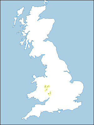 |
Note that the yellow shading represents a buffer to highlight the location of very small areas of the association.
Keys to component soil series
Midlands
 |
Typical Landscapes
Midlands
 |
All information Copyright, Cranfield University © 2025
Citation: To use information from this web resource in your work, please cite this as follows:
Cranfield University 2025. The Soils Guide. Available: www.landis.org.uk. Cranfield University, UK. Last accessed 25/04/2025
