
Soil Associations
0711g WICKHAM 3
Soil and site characteristics
Slowly permeable seasonally waterlogged fine loamy over clayey and coarse loamy over clayey soils and similar more permeable soils with slight waterlogging. Some deep coarse loamy soils affected by groundwater. Landslips with irregular terrain locally.
Geology
Drift over Mesozoic and Tertiary clay and loam
Cropping and Land Use
Cereals and grassland with dairying; deciduous and coniferous woodland and wet lowland heath habitats in the New Forest.
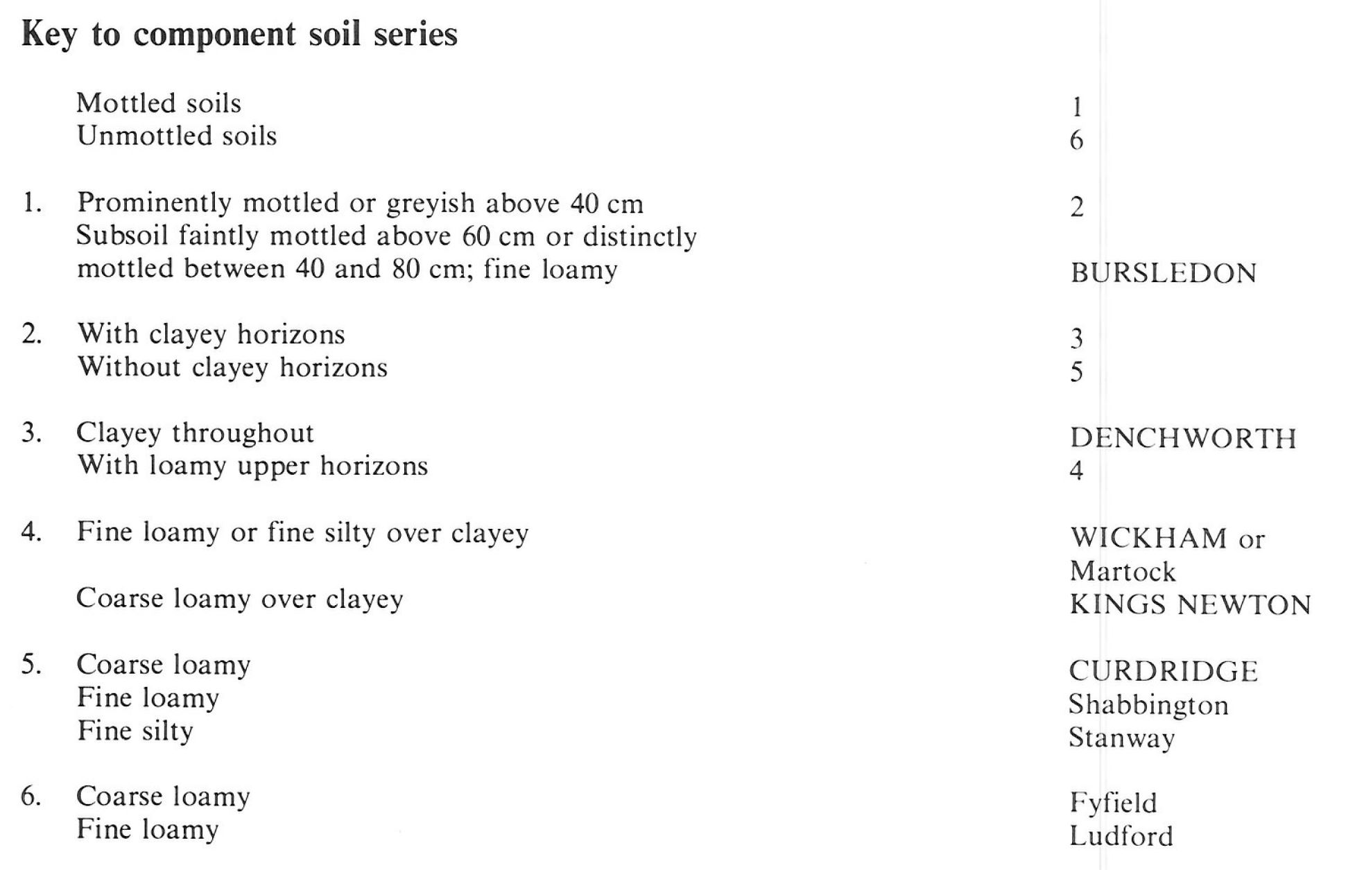
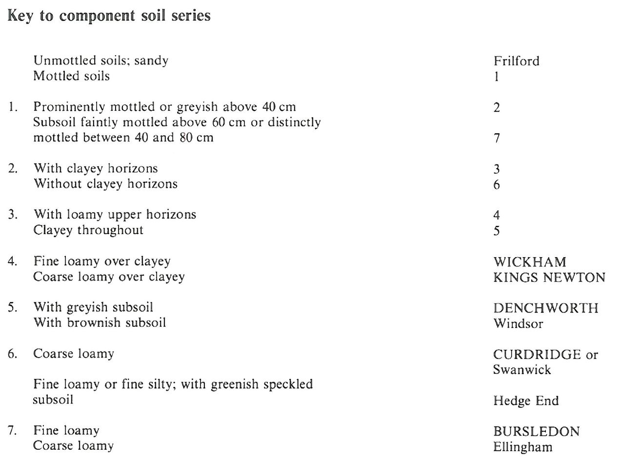
Component soil series
| Subgroup | Series name | Percentage | WRB 2006 link |
|---|---|---|---|
| 7.11 | WICKHAM | 40% | Eutric Luvic Planosols |
| 7.11 | KINGS NEWTON | 20% | Ruptic Eutric Luvic Planosols |
| 8.41 | CURDRIDGE | 15% | Luvic Gleysols |
| 5.72 | BURSLEDON | 10% | Endostagnic Luvisols |
| 7.12 | DENCHWORTH | 10% | Eutric Vertic Stagnosols |
Covers 910 km2 in England and Wales
Soilscapes Classification
| 18 |
Slowly permeable seasonally wet slightly acid but base-rich loamy and clayey soils |
0711g WICKHAM 3
Detailed Description
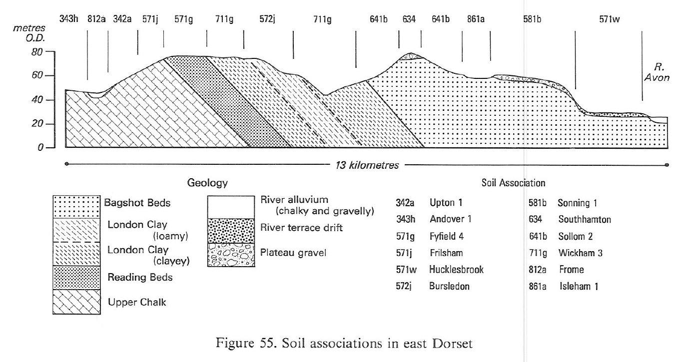
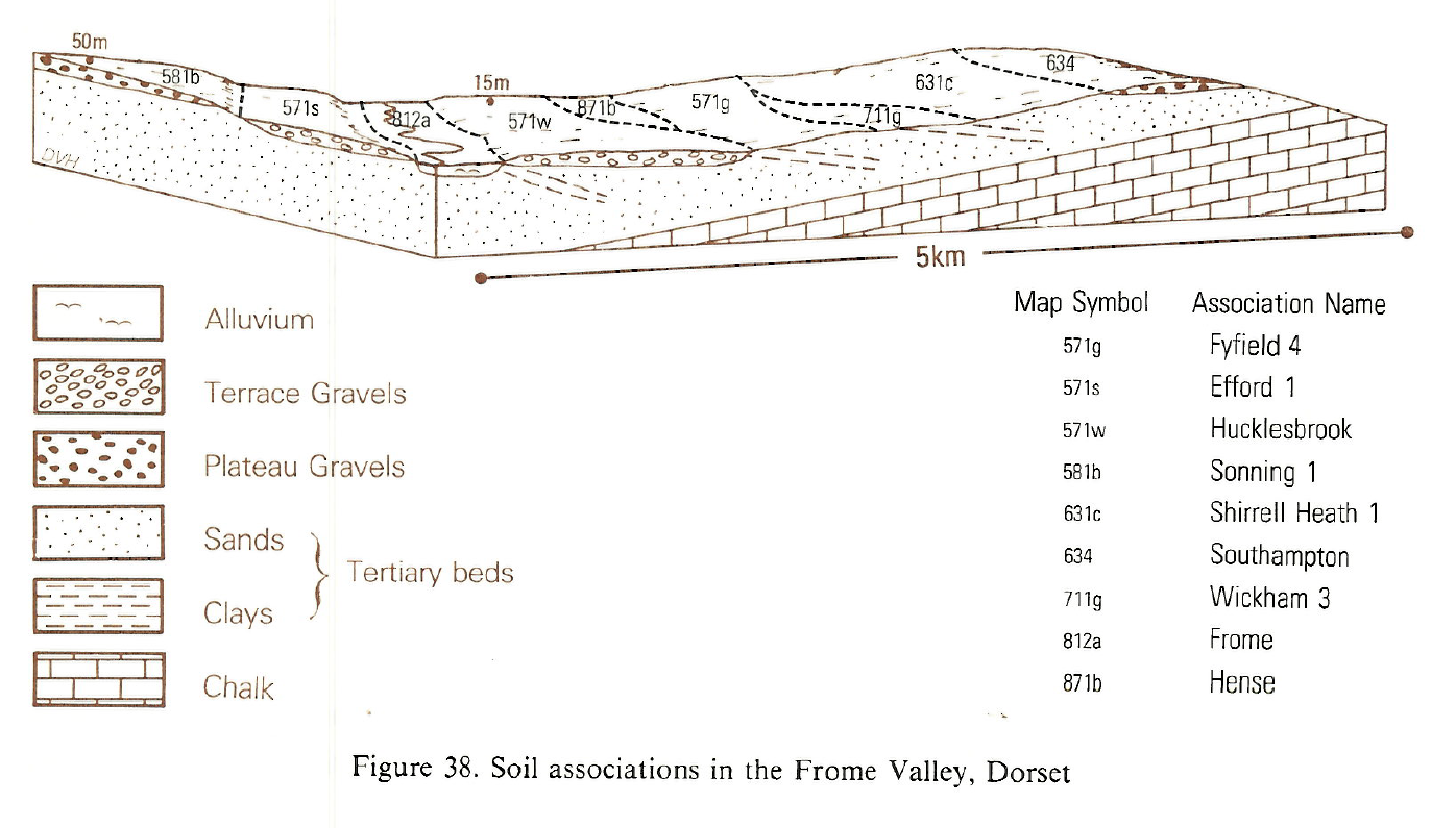
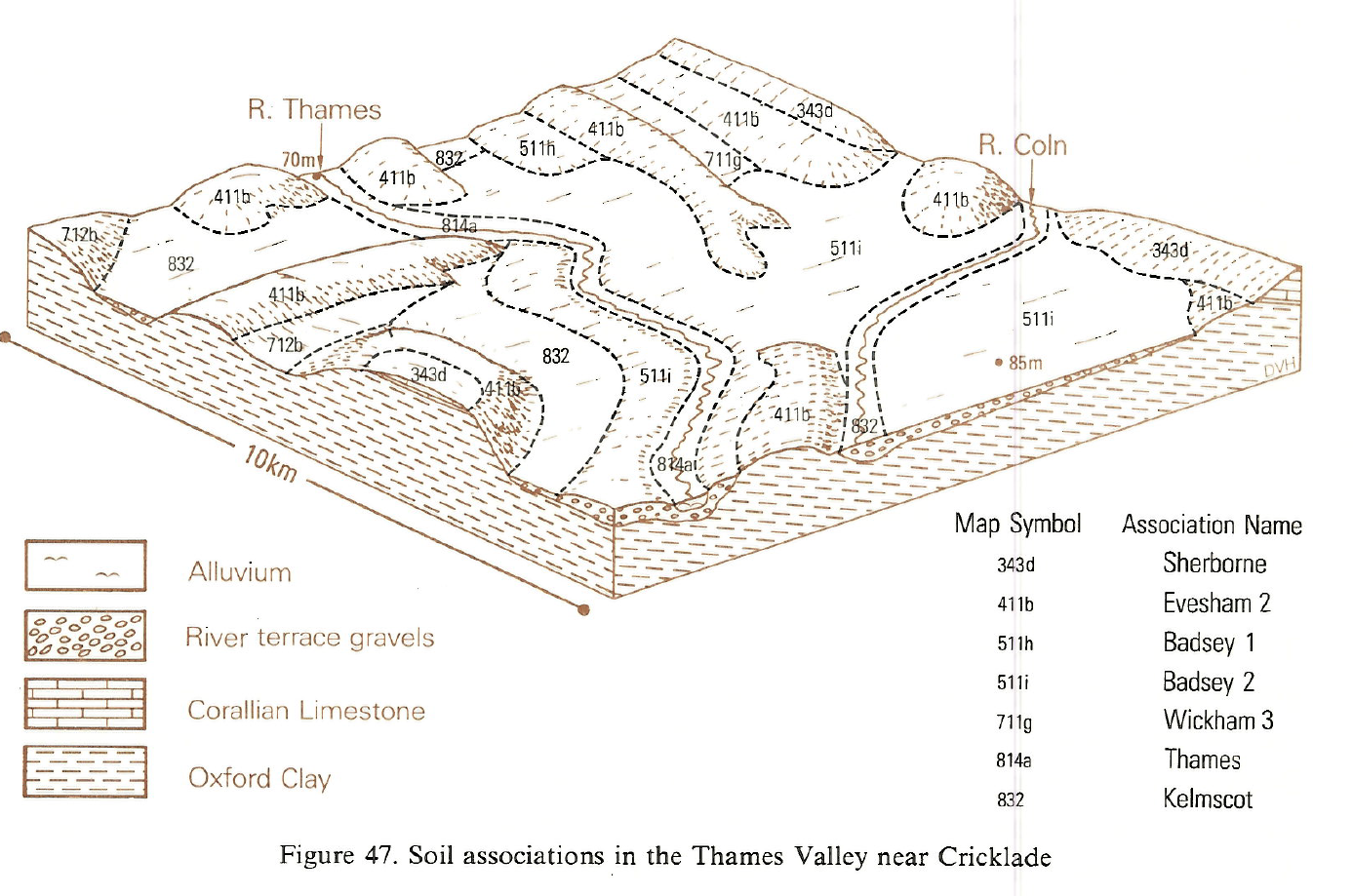
This association is most extensive on Tertiary clays and loams in Berkshire, Surrey, Hampshire and Dorset but occurs also on the lowest beds of the Oxford Clay in north Wiltshire and on Cretaceous Wealden beds in the Isle of Purbeck. The land is gently undulating but there are moderate slopes locally. The predominant Wickham series, which belongs to the typical stagnogley soils, is developed in fine loamy or fine silty drift over clay. Locally, however, coarser drift gives similar but coarse loamy over clayey Kings Newton soils. Deeper loamy soils occur on varied interbedded strata, for example, Bursledon series, fine loamy stagnogleyic argillic brown earths, with ochreous mottled slowly permeable subsoils and Curdridge series, coarse loamy typical argillic gley soils. The latter are affected by groundwater so have grey and ochreous mottling throughout. Strongly mottled clayey Denchworth soils, pelo-stagnogley soils, occur on slopes or in other places where there is little drift.
In Dorset, where there are loamy beds within the London Clay, Bursledon and Curdridge soils are more extensive than elsewhere. Here, too, sandy seams give well drained coarse loamy Fyfield soils. Ludford soils are found on patches of fine loamy and often flinty drift. Locally where loamy drift has accumulated in hollows affected by groundwater, Shabbington soils are found. Where the London Clay is more silty than usual there are Martock and Stanway soils. On the Isle of Purbeck there is a similar range of soils on Wealden interbedded clays, loamy and sands.
In the southern Cotswolds, this association is mapped on knolls and scarps between Malmesbury and Broughton Gifford on the Kellaways Clay facies of the Oxford Clay where it was mapped formerly as Hardenhuish series. Wickham soils are dominant but Bursledon and Curdridge soils occur on loamy strata. Small areas of the association are also mapped amongst the gravelly river terraces of the upper Thames.
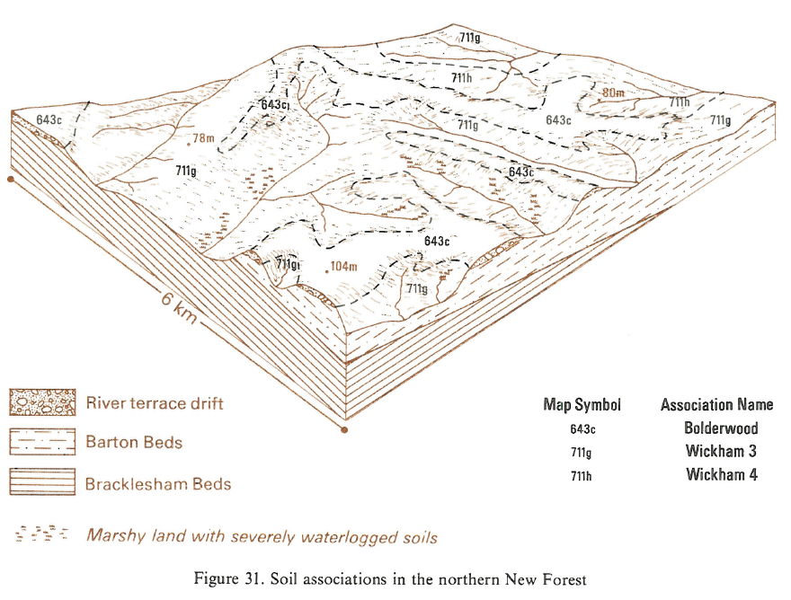
In South East England the soils occur widely on Bracklesham Beds, the more clayey facies of the Bagshot and Barton Beds, and to a lesser extent on the Reading Beds, London Clay and Claygate Beds. Wickham soils occupy more than one-third of the land with Kings Newton soils locally where loamy Bagshot Beds or drift deposits provide superficial coarse loamy material. Curdridge soils are found on loamy Bracklesham and Bagshot Beds, often on footslopes where there is a high water-table. Upper valley slopes on fine loamy strata often carry Bursledon soils and locally there are permeable coarse loamy Ellingham soils. In west Berkshire, where the land was mapped in the Wickham and Windsor associations, and in north Hampshire, clayey Windsor soils with strongly swelling brownish subsoils, are common locally on the London Clay. On the Barton Beds in south Hampshire, Denchworth series is predominant in places. Deep well drained sandy Frilford soils occur sporadically everywhere, often on hilltops capped by Bagshot Beds. Thick loamy flinty drift on footslopes and in valley bottoms give Shabbington and Swanwick soils. Around Inkpen in Berkshire, interfluves capped by gravelly drift have flinty fine loamy Bishampton and fine silty Hamperley soils. Hedge End soils are found on the glauconitic facies of the Bracklesham Beds near Southampton, for example on Baddesley Common. These have prominent green and yellowish brown mottled subsoil horizons containing much glauconite in the sand fraction. Under acid grassland and wet heathland in the New Forest many of the soils have thin humose surface horizons. Here there are active springs, and humose and peaty topsoils are found on wetter footslopes and valley floors. Locally, small areas of Crowdy soils are included.
Soil Water Regime
Most of these soils have slowly permeable clayey subsoils and excess water is disposed of by lateral flow after prolonged periods of heavy rain in winter. Where undrained, Wickham and Denchworth soils are waterlogged for long periods in winter (Wetness Class IV and V) and remain seasonally waterlogged (Wetness Class III) even where field drainage has been installed. Bursledon soils are better drained but subsoils are slowly permeable causing some seasonal waterlogging (drained Wetness Class II or III). The permeable Curdridge soils are waterlogged by groundwater for long periods in the winter (Wetness Class IV).
Wickham and Denchworth soils have moderate reserves of available water. They are slightly droughty for cereals and moderately droughty for grass. Bursledon and Curdridge soils have larger moisture reserves and the effect of drought on crops growing in these soils is less severe.
Cropping and Land Use
Cultivations and cropping on Wickham and Denchworth soils are limited by winter wetness. Wickham soils generally give a finer tilth than the clayey Denchworth series, but because of their relative impermeability and surface waterlogging, cultivations need to be timed very carefully. Autumn ploughing is essential and good yields are obtained from autumn sown cereals where the soils have been drained. There are few opportunities for spring cultivations. Wickham and Denchworth soils poach easily and are inaccessible to machinery in winter so their use for pasture and disposal of slurry is limited, particularly in wetter districts. Curdridge and Bursledon soils are more suitable for slurry disposal and there is The fine and coarse loamy soils which dominate this association are developed in less poaching risk.
In Dorset, where there is a flush of grass in autumn, Bursledon soils are used locally for horticultural crops.The woodland on the London Clay between Dorchester and Fordingbridge, in mainly pedunculate oak, the rest is mixed woodland including ash and larches. There are smaller woodlands on the Weald Clay of the Isle of Purbeck and elsewhere. Coniferous plantations are inextensive. Most are dominated by Corsican pine but there is some of Scots pine and Douglas fir.
In West Sussex and south Hampshire there is a useful flush of grass growth in autumn. Bursledon soils are relatively flexible and are used locally for horticultural crops, particularly in south Hampshire. All the soils are inherently acid and require regular liming for arable use.
Large areas, particularly in south Hampshire, are under old coppice with standards or conifer plantations. Surface waterlogging and compact clay subsoils are the main limitations to tree growth restricting the number of suitable commercial species. Many species suffer from windthrow because of shallow rooting. On Curdridge soils, planting is often limited to poplars, aldar and willows because of groundwater and springs.
In the New Forest, because of its land use history, Forestry Commission policy and planning control, there is much oak and beech woodland. Much of the oak is of poor quality partly because of poor soil fertility and wetness but partly because the best trees have been selectively felled over many centuries. Pines, particularly Corsican pine, have done well as also has Douglas fir where planted on better drained soils.
On commons and in the New Forest, the semi-natural vegetation ranges from heathland and acid grassland to woodland and valley bog. Wickham, Kings Newton and Denchworth series support humid heathland with ling (Calluna vulgaris), cross-leaved heath (Erica tetralix) and purple moor-grass (Molinia caerulea), often with a ground layer of lichens. Wetter footslopes on these soils and minor valley bottoms have wet heathland communities of purple moor-grass, cross-leaved heath, bog asphodel (Narthecium ossifragum) and bog moss (Sphagnum spp). Valley mires with Crowdy series have a particularly rich flora including rare and local bog species. Here purple moor-grass and bog myrtle (Myrica gale) are common with cotton-grass (Eriophorum angustifolium), bog-rush Schoenus nigricans), bogbean (Menyanthes trifoliata) and marsh cinquefoil (Potentilla palustris) and a wide range of bog mosses (Sphagnum spp.). Acid grasslands, often with bracken (Pteridium aquilinum) and scattered ling, occur on Bursledon and Ellingham soils and also on sloping drier sites on Wickham and Kings Newton soils. Here purple moor-grass and bristle agrostis (Agrostis curtisii) are the main plants, their proportions depending on soil wetness. Baddesley Common near Romsey, has acid grassland with some heathland and valley mire. Heathland occurs on Inkpen and Snelsmore Commons in Berkshire. Bookham Common, Surrey, has oak woodland, and acid grassland dominated by tufted hair grass (Deschampsia cespitosa).
0711g WICKHAM 3
Distribution Map
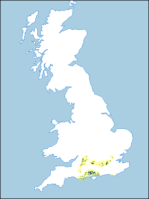 |
Note that the yellow shading represents a buffer to highlight the location of very small areas of the association.
Keys to component soil series
South Western Region
 |
South Eastern Region
 |
Typical Landscapes
South Western Region
 |
South Western Region
 |
South Western Region
 |
South Eastern Region
 |
All information Copyright, Cranfield University © 2025
Citation: To use information from this web resource in your work, please cite this as follows:
Cranfield University 2025. The Soils Guide. Available: www.landis.org.uk. Cranfield University, UK. Last accessed 25/04/2025
