
Soil Associations
0711n CLIFTON
Soil and site characteristics
Slowly permeable seasonally waterlogged reddish fine and coarse loamy soils and similar soils with slight seasonal waterlogging. Some deep coarse loamy soils seasonally affected by groundwater.
Geology
Reddish till
Cropping and Land Use
Cereals and grassland, some potatoes in Staffordshire; grassland In the Northern Region.
Component soil series
| Subgroup | Series name | Percentage | WRB 2006 link |
|---|---|---|---|
| 7.11 | CLIFTON | 45% | Chromic Eutric Albic Luvic Stagnosols |
| 7.11 | CLAVERLEY | 20% | Chromic Eutric Albic Luvic Stagnosols |
| 5.72 | SALWICK | 20% | Chromic Endostagnic Luvisols |
| 8.31 | QUORNDON | 10% | Eutric Gleysols |
Covers 2463 km2 in England and Wales
Soilscapes Classification
| 18 |
Slowly permeable seasonally wet slightly acid but base-rich loamy and clayey soils |
0711n CLIFTON
Detailed Description
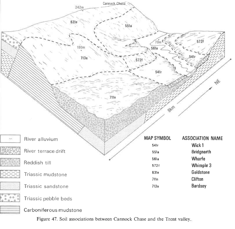
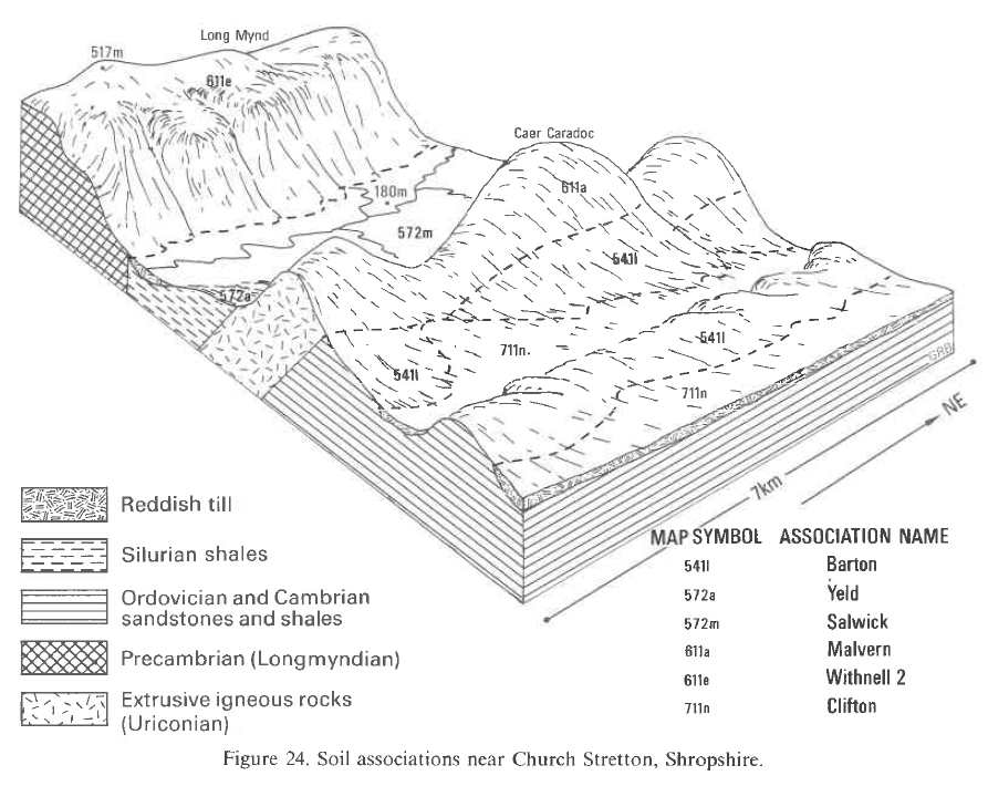
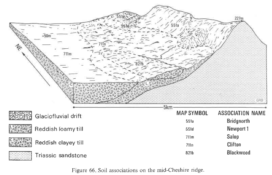
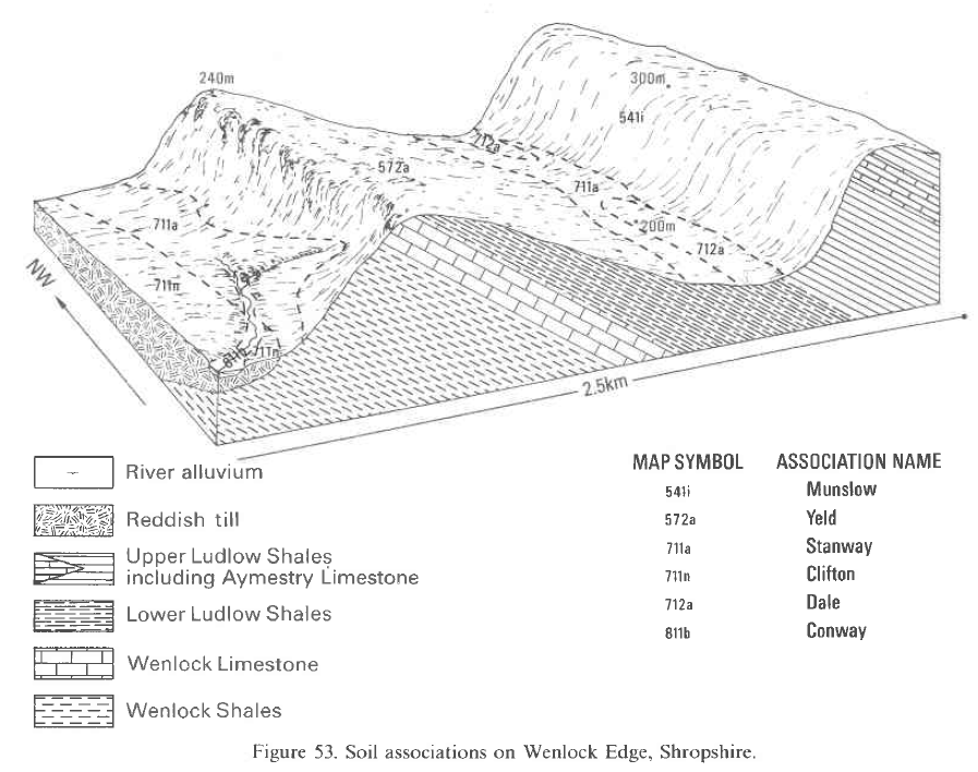
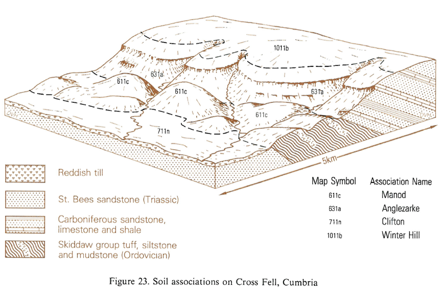
The Clifton association consists of seasonally waterlogged soils developed in reddish fine loamy till and related glaciofluvial deposits. It usually forms gently undulating terrain, but the land is deeply incised by rivers and streams in places. The association is extensive south and west of the Pennines, from south Staffordshire and Clwyd to the Scottish border. East of the Pennines it is restricted to Teesside. The till, mainly of Devensian age, is derived from Permo-Triassic sandstones and mudstones and is non-calcareous or decalcified to at least 80 cm depth. It is generally dense and slowly permeable, but contains occasional pockets of sand and gravel and, in many areas is overlain by coarse loamy glaciofluvial deposits, usually less than 70 cm thick with an irregular lower boundary. Because of the slowly permeable nature of the till, the soils are mainly typical stagnogley soils. Clifton series is developed where the overlying glaciofluvial deposits are absent or relatively thin (less than 40 cm thick) and the Claverley series, formerly classified as a deep sandy loam phase of the Clifton series, is found where this drift is thicker. Fine loamy stagnogleyic argillic brown earths of the Salwick series occur on upper slopes. Coarse loamy ground-water gley soils of the Quorndon series are found mainly in thick glaciofluvial deposits along streams and in hollows. Small areas of Arrow, Wick or Newport soils are also included, usually on isolated sandy or other deep permeable glaciofluvial deposits in hummocky terrain. The association covers approximately 1145 km² mainly on Devensian till in Staffordshire, Shropshire and Cheshire, but also on remnants of older Wolstonian tills fringing the Birmingham plateau and extending southwards into Warwickshire along the Ridgeway as far as Bromsgrove and Redditch. It ranges in altitude from about 15 m O.D. on the Wirrall peninsula to 160 m O.D. in the Pennine foothills east of Macclesfield. The map unit extends northwards from Wolverhampton, Bridgnorth and Wenlock Edge, through north-east Shropshire and central Staffordshire, to the morainic country bordering the Cheshire lowlands from Whitchurch to Macclesfield. It also skirts the north Shropshire lowlands and extends into Cheshire along the Triassic sandstone outcrops of the mid-Cheshire and Wirrall ridges. Occasional Brickfield soils are found between Cheadle and Macclesfield where the reddish till merges into brownish drifts containing Carboniferous-derived material. Similarly, Cegin and Brickfield soils occur along the north Welsh Borderland and Pinder profiles are included between Church Stretton and Shrewsbury where the parent material includes local and Welsh Lower Palaeozoic rocks. In the south, the till is covered extensively by spreads of glaciofluvial outwash so Claverley soils dominate. North of Wolverhampton and west of Bridgnorth, however, the coarse superficial drift becomes progressively less extensive and Claverley soils are less common. Elsewhere in Shropshire and Cheshire there are small patches of Rufford, Salop and to a lesser extent Astley Hall and Flint soils where the till is clayey. Isolated areas of Whimple and Brockhurst or Bromsgrove and Bridgnorth soils occur in central and southern Staffordshire where the till thins over reddish, Triassic or Upper Coal Measures mudstones or sandstones. On the recently reclaimed upland around Chartley Park in central Staffordshire the association includes Lea soils which have profiles similar to the Clifton series, but with humose topsoils resulting from the cultivation and mixing of thin superficial organic layers with the mineral subsoil. Near Birmingham and in Warwickshire on Wolstonian till, Rufford, Salop, Flint and Astley Hall profiles are common.
This association covers 52 km² in Clwyd with a further 16 km² in the Vale of Glamorgan, and occurs from sea level to 130 m O.D. It is extensive south-west of the Dee estuary from Hawarden to Holywell passing over a ridge westwards into the Alun valley near Mold. Small areas occur in the Vale of Clwyd , and in shallow depressions in morainic drift around Cardiff. Clifton and Salop soils are dominant but greyish surface-water gley soils of the Brickfield, Cegin and Greyland series are also present.
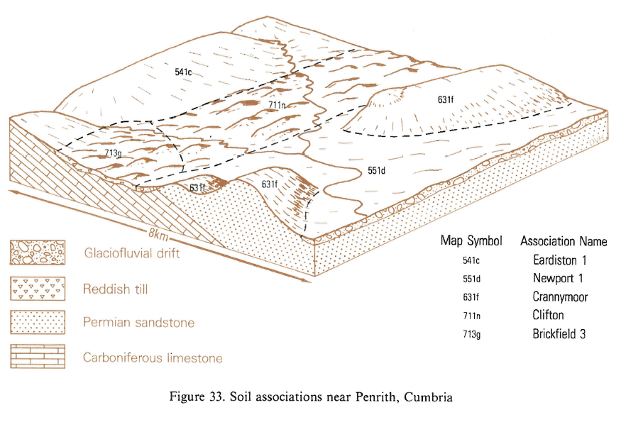
The association covers approximately 196 km², in Cumbria, Durham and North Yorkshire. It is widespread along the Solway coast as far south as Maryport, in the Vale of Eden and around the western fringes of the Lake District. Altitudes range from about 12 m O.D. near the mouths of the Esk and Eden to almost 850 m O.D. in the Eden valley. On the Solway plain, the Lea series, which is similar to the Clifton series, but with a humose or peaty topsoil, is common in wet hollows, the larger of which also include Floriston series. North and east of Carlisle, there are small inclusions of Salop soils where the till is clayey, being mainly derived from underlying Mercia Mudstone. Near Penrith, Salwick soils are common and further south, near King's Meaburn, where the till overlies limestone, the soils are usually calcareous at depth and commonly contain fragments of limestone. Occasional typical stagnogley soils similar to the Clifton series but with limestone bedrock at less than 80 cm depth, are included. East of the Pennines, the map unit occurs in small patches between Stockton-on-Tees, Darlington and Northallerton. Salop, Flint or less commonly Crewe profiles are found where the parent material is clayey. Brickfield and Dunkeswick soils are included locally where the till is brownish and influenced by Carboniferous rocks.
Soil Water Regime
Clifton and Claverley series have slowly permeable subsoils and their upper horizons are seasonally waterlogged (Wetness Class IV). Drainage measures significantly reduce the duration of waterlogging in Clifton profiles (Wetness Class III), but have an even greater effect on Claverley soils. Like the Clifton series, Salwick soils are slowly permeable but, being on slopes, shed more water by surface run-off and their upper horizons do not stay wet for quite as long (Wetness Class III). Quorndon soils suffer from seasonal waterlogging by groundwater for most of the winter (Wetness Class III or IV). Underdrainage is very effective however and normally ensures that the soils stay well drained in all but the wettest seasons (Wetness Class I). In most of the soils, water moves laterally through the topsoil or immediate subsoil (above 40 cm depth) and, in general, they tend to shed excess winter rain.
Cropping and Land Use
The soils of the Clifton association are mainly under cereals and grass. Their major limitation is that of wetness but where drained, the soils produce good yields of common agricultural crops. In the Wolverhampton and Bridgnorth area, where the climate is relatively dry and topsoils are mainly coarse loamy and easily worked, potatoes and sugar beet are frequently included in the rotation. Further west and north, however, root crops are less common because the wetter climate and predominance of fine loamy topsoils make late harvesting difficult. In Cheshire, the soils are traditionally under long-term grassland with only occasional cereal breaks, but a wider range of arable or horticultural crops can be grown with careful management. Around Macclesfield, in the Pennine foothills, where an annual rainfall of 850 mm precludes root crops, there is widespread permanent grassland with some ley grassland and cereals on large farms. Plant roots cannot fully exploit the often compact, coarsely structured subsoils of Clifton, Claverley and Salwick soils and they have small or moderate reserves of profile available water. In the driest areas therefore, potatoes may suffer slightly from drought and grassland tends to scorch in dry summers. Quorndon soils however are non-droughty having larger water reserves and, in places, groundwater available to plant roots. A good tilth can usually be obtained without special machinery or winter frost, but cultivations need to be carefully timed to minimize structural damage and the formation of plough pans, particularly in spring. Once subsoils have become wet in the winter, they remain saturated for most of the season and if cultivations are carried out under these conditions, compaction occurs below the plough sole, forming a pan. This in turn impedes the downward percolation of water, producing additional saturated layers which slake internally causing further compaction. Around Macclesfield, the relatively high rainfall means that there are few opportunities, even for autumn cultivations and here, careful timing is critical. Plough pans are best destroyed by subsoiling which should be a regular requirement for all constituent soils, especially after the late harvesting of root crops. Timing is important, however, and operations should not be carried out when subsoils are wet, as this causes further compaction and structural damage. Although all the soils contain stones, these rarely restrict cultivation or available water. South of Cannock Chase however, many soils have more than 15 per cent stones, which cause excessive wear on machinery and hinder the mechanized harvesting of root crops. In the Wolverhampton, Bridgnorth and Wenlock Edge areas there are occasional large boulders which tend to work towards the surface and can damage farm machinery. Under permanent grassland, organic matter contents tend to be relatively large so that topsoils retain large amounts of water. Because of this and subsoil waterlogging, the soils poach readily in spring and autumn. The risk is particularly severe in north-east Staffordshire and Cheshire if stock are put out before the end of April and kept out after mid-October. Further south and west, the number of safe grazing days is greater, but even in the driest areas, grazing during April or November will involve appreciable poaching risk. The soils generally have a moderate cation exchange capacity and are inherently fertile. Although the parent material is often calcareous, with high percentage base saturation, soils are usually decalcified to below 1 m depth and topsoils need occasional dressings of lime. Amounts of naturally available phosphorus and potassium are small, especially in Quorndon and Claverley soils, but with regular fertilizer applications deficiencies are rare. There is normally a moderate and well balanced supply of trace elements, but manganese deficiency sometimes occurs where liming has raised the pH above neutral.
0711n CLIFTON
Distribution Map
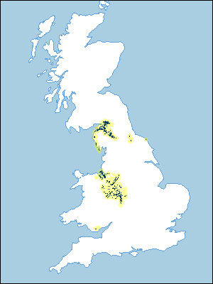 |
Note that the yellow shading represents a buffer to highlight the location of very small areas of the association.
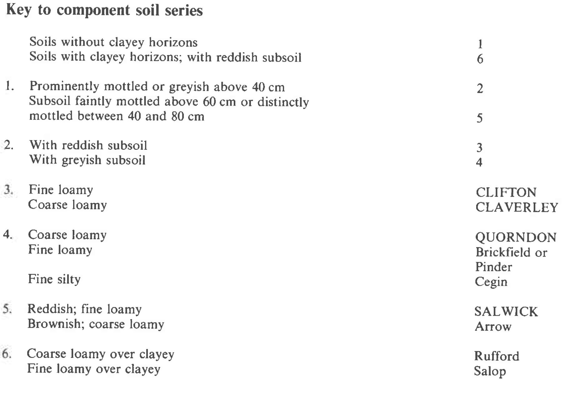
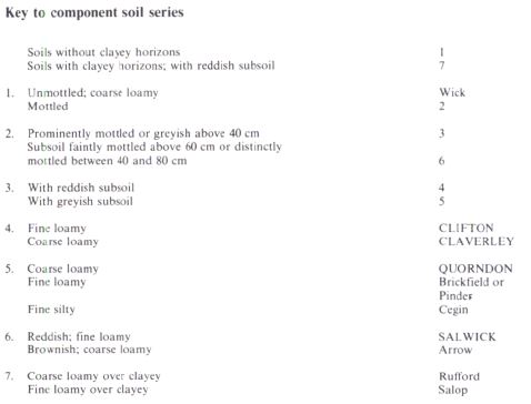
Keys to component soil series
Midlands
 |
Northern Region
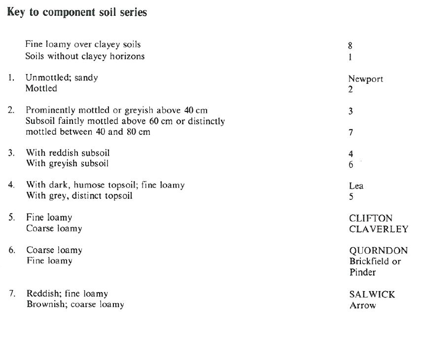 |
Wales
 |
Typical Landscapes
Midlands
 |
Midlands
 |
Midlands
 |
Midlands
 |
Northern Region
 |
Northern Region
 |
All information Copyright, Cranfield University © 2025
Citation: To use information from this web resource in your work, please cite this as follows:
Cranfield University 2025. The Soils Guide. Available: www.landis.org.uk. Cranfield University, UK. Last accessed 25/04/2025
