
Soil Associations
0711p DUNKESWICK
Soil and site characteristics
Slowly permeable seasonally waterlogged fine loamy and fine loamy over clayey soils associated with similar clayey soils.
Geology
Till from Palaeozoic and Mesozoic sandstone and shale
Cropping and Land Use
Grassland in moist lowlands, some arable cropping in drier lowlands.
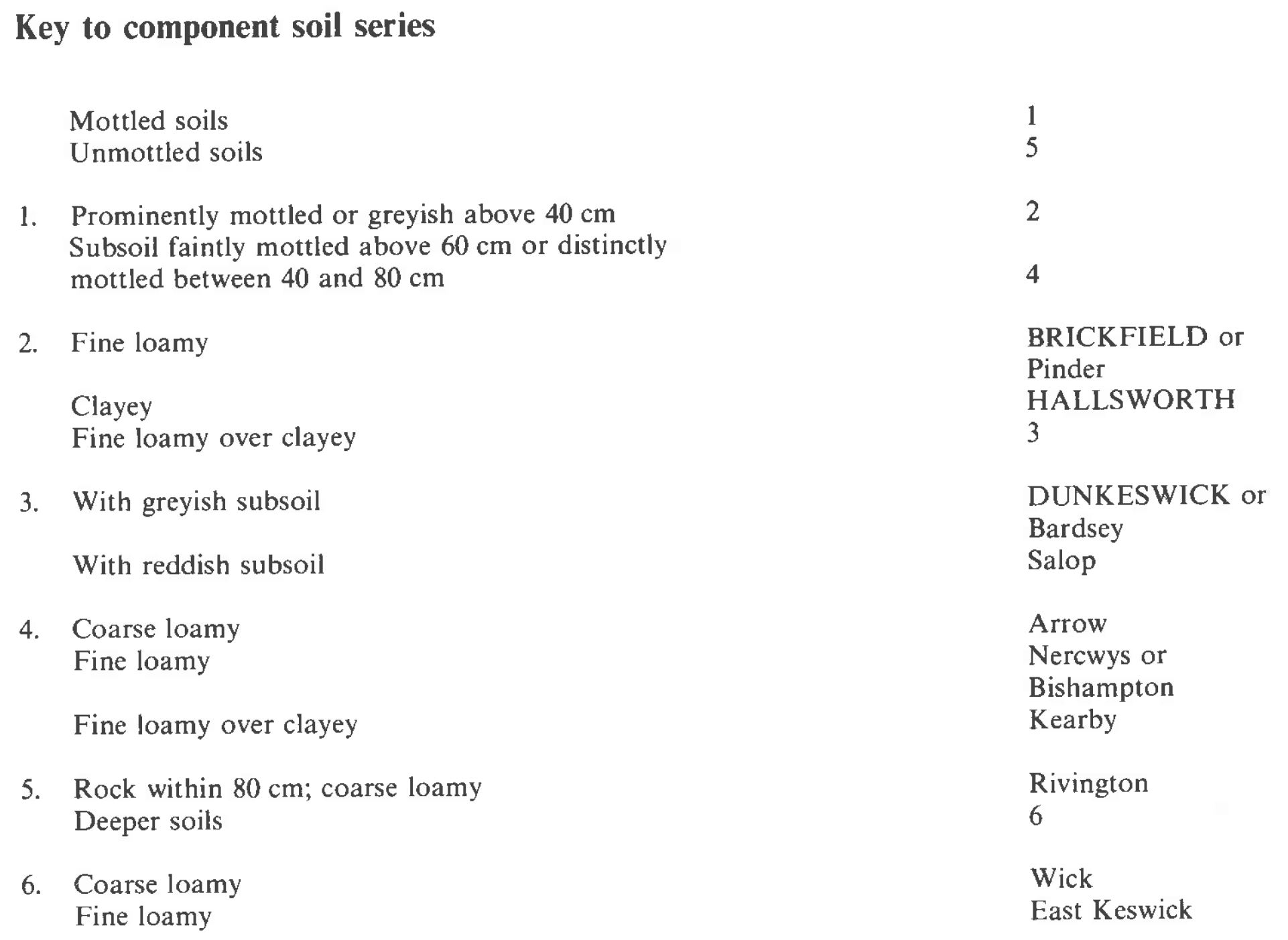
Component soil series
| Subgroup | Series name | Percentage | WRB 2006 link |
|---|---|---|---|
| 7.11 | DUNKESWICK | 55% | Eutric Albic Luvic Stagnosols |
| 7.13 | BRICKFIELD | 25% | Eutric Stagnosols |
| 7.12 | HALLSWORTH | 10% | Clayic Eutric Stagnosols |
Covers 3002 km2 in England and Wales
Soilscapes Classification
| 18 |
Slowly permeable seasonally wet slightly acid but base-rich loamy and clayey soils |
0711p DUNKESWICK
Detailed Description
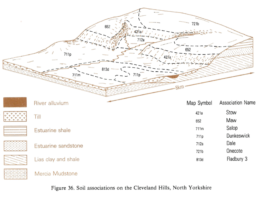
The association is dominated by stagnogley soils in greyish brown drift derived mainly from Carboniferous shales, but often containing Jurassic and Triassic sandstones or occasional limestones. It occurs on gently to moderately sloping land from sea level to about 300 m O.D. The association is most extensive in Northern England but also occurs in parts of the Midlands and South West England. The main soils are the fine loamy over clayey Dunkeswick series, typical stagnogley soils, the predominantly fine loamy Brickfield series, cambic stagnogley soils, and the clayey Hallsworth series, pelo-stagnogley soils. Hallsworth soils are usually found on convex upper slopes, with Brickfield and Dunkeswick on the middle and lower slopes. The association covers 76 km², distributed patchily on the flanks of the Derwent, Dove and Ecclesbourne valleys in Derbyshire and Staffordshire and near Annesley Woodhouse in Nottinghamshire. It is found mainly on gentle upper slopes and hilltops, but in the Ecclesbourne valley it occurs on lower slopes also. Dunkeswick soils generally occupy two-thirds of the area, Brickfield being the second most important series and Hallsworth soils rare. Where the land is above 250 m O.D., Kielder and Wilcocks soils are included, typically in hollows and around flush sites. In places, Kearby soils (Bridges 1966) are found on moderately sloping land, as for example around Shottle, and can occupy up to one-quarter of the area. Local thinning of the till over Carboniferous mudstone gives Bardsey and Ticknall soils. Around Ashbourne, Chaddesden and near Annesley Woodhouse, reddish tills derived mainly from Triassic rocks are interlayered with the greyish till and give rise to discrete inclusions of Salop soils. Pinder soils are included in a small delineation south of Ross-on-Wye.
These soils occupy 46 km² of gently undulating land at altitudes of 60 to 180 m O.D. in the Forest of Dean and a small area west of Vobster in Somerset. The Dunkeswick soils, in stony fine loamy over clayey drift from Carboniferous sandstone and shale, cover approximately half the area. Proportions of other soils vary according to the nature of the drift. In and around the Forest of Dean, Pinder and Loquiers soils are common in stony fine loamy and coarse loamy over clayey drift and Hallsworth soils occur in clayey drift. Small areas of fine silty Bardsey and clayey Dale soils are developed in siltstones, especially east of St Briavels.
This is the second most extensive association in Northern England and occupies about 2550 km², mainly east of the Pennines, between Pontefract and Berwick-Upon-Tweed. The composition is relatively uniform but included throughout are alluvial soils in valleys too small to distinguish separately. In West Yorkshire it occurs in small areas of drift over Coal Measures shales, where the soils are difficult to distinguish from those of the Bardsey series, in shales. Here and elsewhere, soils in Head rather than till are also included. The association flanks the Pennine dales in North Yorkshire and Durham, the North York Moors and the Howardian Hills. The Dunkeswick series covers approximately half of the area, Brickfield and Hallsworth occupying much of the remainder. In the undulating till plain between these uplands varying proportions of the reddish Salop series occur because of the proximity of red Permo-Triassic rocks. Wick and Arrow series, on morainic and glaciofluvial deposits, are also included where these are too small to map separately. In Northumberland, the association occupies small areas because of the more dissected landscape and generally includes more soils over sandstone, such as the Rivington series, as well as the fine loamy Brickfield and Wilcocks series. In places the deep subsoil is slightly calcareous because of included limestone fragments. In many of the profiles soft rotting sandstones are common.
Soil Water Regime
Being slowly permeable, the clayey subsoil impedes percolation and causes rapid run-off of rainwater in winter. Without artificial drainage the soils are seasonally waterlogged for long periods in winter (Wetness Class IV) but well conceived drainage measures can reduce waterlogging significantly (Wetness Class III). The loamy subsurface layer, with its occasional hard or rotted stones, makes mole drainage unsuitable as an after-treatment, and for the best results these soils require permeable fill with regular subsoiling.
Cropping and Land Use
Much of the land is suited only to seasonal pasture and livestock rearing predominates. The soils poach easily and are generally inaccessible for stock and machinery in winter. Although grass is the best use in most areas, large stocking densities cannot be sustained. In dry districts where the field capacity period is less than 175 days, such as near Derby and Annesley Woodhouse, the soils are suitable for arable cropping and intensively managed grassland. The slow permeability and seasonal surface wetness restrict the number of machinery work days, especially in spring. The soil dries out slowly and cultivations must be carefully timed to avoid damage to the soil structure. Cropping is therefore mostly restricted to autumn-sown cereals but harvesting can cause damage in wet seasons.
Most of the agricultural land surrounding the Forest of Dean is in long term grassland, with small areas in ley-arable rotation. The soils poach easily and cultivation can be difficult because of the long periods of subsoil waterlogging which restrict the number of good machinery work days. Corsican pine has been found to be the most successful conifer on these mainly stagnogley soils, which underlie about one third of the Forest of Dean, but Sitka spruce is also widely planted. Norway spruce grows well but suffers from windthrow and its growth is checked by long periods of spring frost. Dunkeswick soils produce good oak timber and beech grows well in mixtures with oak. A more detailed account of forestry and its relation to soils in the Forest of Dean is given by Colborne .
The soils are suitable for forestry, especially where the land is not too exposed, and good yields are obtained from most conifers. Deep drainage is essential to promote root development and thus secure anchorage against the wind at early stages of growth. Kielder Forest, Northumberland, is mainly Norway spruce and Japanese larch with some Douglas fir and beech, the last being remnants of old woodland. Norway spruce was chosen because of its tolerance to frosts which are especially common in valley bottoms. Plantations north of Harrogate are of Scots pine, Sitka spruce and Japanese and European larch, with a small quantity of beech and sycamore for amenity.
0711p DUNKESWICK
Distribution Map
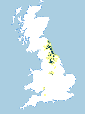 |
Note that the yellow shading represents a buffer to highlight the location of very small areas of the association.
Keys to component soil series
Midlands
 |
Northern Region
 |
Typical Landscapes
Northern Region
 |
All information Copyright, Cranfield University © 2025
Citation: To use information from this web resource in your work, please cite this as follows:
Cranfield University 2025. The Soils Guide. Available: www.landis.org.uk. Cranfield University, UK. Last accessed 25/04/2025
