Soil Associations
0711s BECCLES 2
Soil and site characteristics
Slowly permeable seasonally waterlogged fine and coarse loamy over clayey soils. Some deep sandy soils affected by groundwater.
Geology
Chalky till and glaciofluvial drift
Cropping and Land Use
Cereals and some sugar beet and potatoes; some grassland.
Component soil series
| Subgroup | Series name | Percentage | WRB 2006 link |
|---|---|---|---|
| 7.11 | BECCLES | 60% | Eutric Albic Luvic Stagnosols |
| 7.11 | ALDEBY | 20% | Albic Ruptic Luvic Planosols |
| 8.21 | BLACKWOOD | 15% | Arenic Mollic Gleysols |
Covers 99 km2 in England and Wales
Soilscapes Classification
| 18 |
Slowly permeable seasonally wet slightly acid but base-rich loamy and clayey soils |
0711s BECCLES 2
Detailed Description
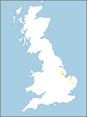
This association, which covers 97 km², consists of Beccles and Aldeby series, typical stagnogley soils, and Blackwood series, sandy gley soils. Beccles series has fine loamy, and Aldeby series coarse loamy topsoil over slowly permeable clayey subsoils with chalk stones, but the Blackwood soils are sandy throughout. The association occurs on flat or gently sloping land in Norfolk and in small areas in north and central Lincolnshire. It is usually found on chalky till with patches of gravel, but in north Lincolnshire it occurs where the till has a thin cover of aeolian material. Included are small areas of Quorndon soils. Brief profile descriptions of the main component series are given below.
In Norfolk the association occurs on crests at 50-70 m O.D. but in Lincolnshire is on lower ground, ranging from 2 m O.D. on the fen margin to 30 m O.D. in mid-Lincolnshire near Market Rasen. It also occurs in the Witham valley south-east of Lincoln. There is some variation in the proportions of component soils. Generally, Beccles series is dominant with significant proportions of Aldeby and Blackwood series, but in Lincolnshire, Blackwood series is relatively inextensive and here there are some Quorndon soils. In Norfolk, Aldeby and Beccles series occur together, Blackwood soils mainly being in discrete patches on the highest ground.
Soil Water Regime
Beccles and Aldeby soils are seasonally waterlogged (Wetness Class III) because of their slowly permeable subsoils, but in Lincolnshire, where perimeter ditches are linked to pumped arterial systems, Blackwood soils are only occasionally waterlogged (Wetness Class II). There are marked year to year differences in the duration of waterlogging. Penetration of excess winter rainfall is generally restricted by clayey subsoils which causes lateral flow at shallow depth. Beccles and Aldeby soils are generally slightly droughty for the main arable crops but the sandy Blackwood soils are generally more droughty and are moderately droughty for potatoes and very droughty for grass in Lincolnshire. In Norfolk under higher rainfall they are slightly droughty for potatoes, moderately droughty for grass and non-droughty for sugar beet.
Cropping and Land Use
The average field capacity period is 120 to 150 days and tends to restrict spring rather than autumn field operations. The main crops are cereals with sugar beet, peas and beans but there is some mixed farming including dairying and beef production. Where irrigation is unavailable, grass growth is limited to spring and early summer so the land is unsuited to intensive production. Poaching risk is slight on Aldeby and Blackwood soils but Beccles soils poach more readily. The yield of direct-drilled winter cereals is similar to that under conventional cultivations but yields of spring crops are likely to be smaller than those sown after traditional ploughing. Available potassium levels are medium in Beccles and Aldeby soils but low in Blackwood soils. Phosphorus status depends on past management. Regular liming is necessary but manganese deficiency commonly occurs on Blackwood and Aldeby soils that have been overlimed. There is some broad-leaved and coniferous woodland in Norfolk.
0711s BECCLES 2
Distribution Map
 |
Note that the yellow shading represents a buffer to highlight the location of very small areas of the association.
Keys to component soil series
Eastern Region
 |
All information Copyright, Cranfield University © 2025
Citation: To use information from this web resource in your work, please cite this as follows:
Cranfield University 2025. The Soils Guide. Available: www.landis.org.uk. Cranfield University, UK. Last accessed 25/04/2025
