Soil Associations
0713e BRICKFIELD 1
Soil and site characteristics
Slowly permeable seasonally waterlogged fine loamy and fine silty soils, some with wet peaty surface horizons.
Geology
Drift from Palaeozoic slaty mudstone and siltstone
Cropping and Land Use
Stock rearing on permanent grassland and wet moorland of moderate and good grazing value.
Component soil series
| Subgroup | Series name | Percentage | WRB 2006 link |
|---|---|---|---|
| 7.13 | BRICKFIELD | 30% | Dystric Stagnosols |
| 7.21 | WILCOCKS | 25% | Umbric Stagnosols |
| 7.13 | GREYLAND | 15% | Dystric Stagnosols |
| 7.13 | CEGIN | 10% | Dystric Stagnosols |
Covers 458 km2 in England and Wales
Soilscapes Classification
| 17 |
Slowly permeable seasonally wet acid loamy and clayey soils |
0713e BRICKFIELD 1
Detailed Description
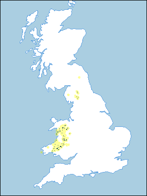
This association consists mainly of fine textured wet soils of the Brickfield, Cegin, Greyland and Wilcocks series and covers 420 km² in Wales with 47 km² in Cumbria. It is most extensive in the western and central parts of mid-Wales on the flanks of valleys and in basins where local drift has accumulated. The drift is largely till with some Head, the stones consisting mainly of mudstone and siltstone and occasionally sandstone and quartz. Developed on gentle slopes, the soils are slowly permeable and waterlogged for long periods in winter, and, especially where the topsoil is humose or peaty, well into the growing season. Most of the land is between 250 and 300 m O.D., but the association ranges from near sea level in Gwynedd to over 400 m O.D. on the slopes of Aran Benllyn. The Brickfield, Cegin and Greyland series are cambic stagnogley soils, and the Wilcocks series consists of stagnohumic gley soils with peaty or, less commonly, humose topsoils. In flushes, valleys and basins where soils are relatively permeable and affected by groundwater, the Freni series is found. At higher altitudes or in basins with little drainage outlet there are peat soils of the Crowdy or Winter Hill series. The proportions of fine loamy Brickfield and fine silty Cegin soils vary from place to place, but Brickfield is dominant in most localities. In some districts Wilcocks series is widespread. Manod, Rheidol and Nefern profiles are generally inextensive, occasionally occurring on higher drier ground in the generally wet landscape. There is usually a distinct break of slope to steeper ground where the association meets the drier Manod association and in places it is marked by spring-lines with wet peaty flushes. Alluvial soils in narrow valleys, too small to separate at the map scale, are mostly typical and humic alluvial gley soils. In parts of mid- and south-west Wales as at Crychell and Fedw-ddu periglacial modification of the drift has resulted in pingo scars (Bradley 1980). These form circular or arcuate ridges - the ramparts of former ice-cored mounds - which usually enclose small areas of Freni and Crowdy soils. The ramparts consist of compact drift on which shallow stagnogleyic rankers of the Eriviat series (Clayden and Hollis 1984) are developed.
In Cumbria the association occurs on the northern footslopes of the Howgill Fells and on part of the Pennine escarpment near Dufton. Cegin soils are dominant throughout, with Wilcocks more common on the Howgill Fells than on the Pennines. On steeper slopes where the drift is thinner, Manod and Denbigh profiles occur. The climate is generally cold, wet and exposed, with accumulated temperatures in the range 825 to 1375 day degrees centigrade and moisture deficits of 40 to 60 mm.
Soil Water Regime
Soil wetness and the cool moist climate make arable use of the land uneconomic, so most is under permanent grass. Some is periodically reseeded but many once-improved grasslands have reverted to rushy pastures. Much of the wettest land is under Molinia which has little value for grazing. An efficient drainage system is essential for grassland production. Liver fluke is a hazard to stock where the land is undrained. Drainage measures in Brickfield and Cegin series probably improve their Wetness Class only from IV or V to III or IV so the soils remain susceptible to poaching and compaction; especially soils of the Wilcocks series with their peaty or humose surface horizons.
Cropping and Land Use
The land is best suited to seasonal grazing in conjunction with adjacent drier ground such as that in the Manod association. There is little forestry, although the land is moderately suited for this use. Surface wetness is a minor limitation for forestry on Brickfield and Cegin soils, but is more serious on Wilcocks series, because the longer periods of waterlogging restrict rooting. This reduces yield and seedling establishment, and makes trees susceptible to windthrow in exposed areas.
0713e BRICKFIELD 1
Distribution Map
 |
Note that the yellow shading represents a buffer to highlight the location of very small areas of the association.
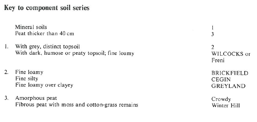
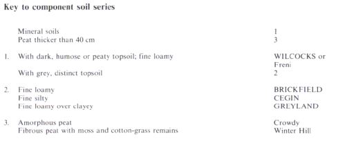
Keys to component soil series
Northern Region
 |
Wales
 |
All information Copyright, Cranfield University © 2025
Citation: To use information from this web resource in your work, please cite this as follows:
Cranfield University 2025. The Soils Guide. Available: www.landis.org.uk. Cranfield University, UK. Last accessed 25/04/2025
