
Soil Associations
0713f BRICKFIELD 2
Soil and site characteristics
Slowly permeable seasonally waterlogged fine loamy soils. Associated with fine loamy soils with only slight waterlogging and some deep well drained fine loamy soils.
Geology
Drift from Palaeozoic and Mesozoic sandstone and shale
Cropping and Land Use
Dairying and stock rearing on permanent or short term grassland; some cereals in drier areas.
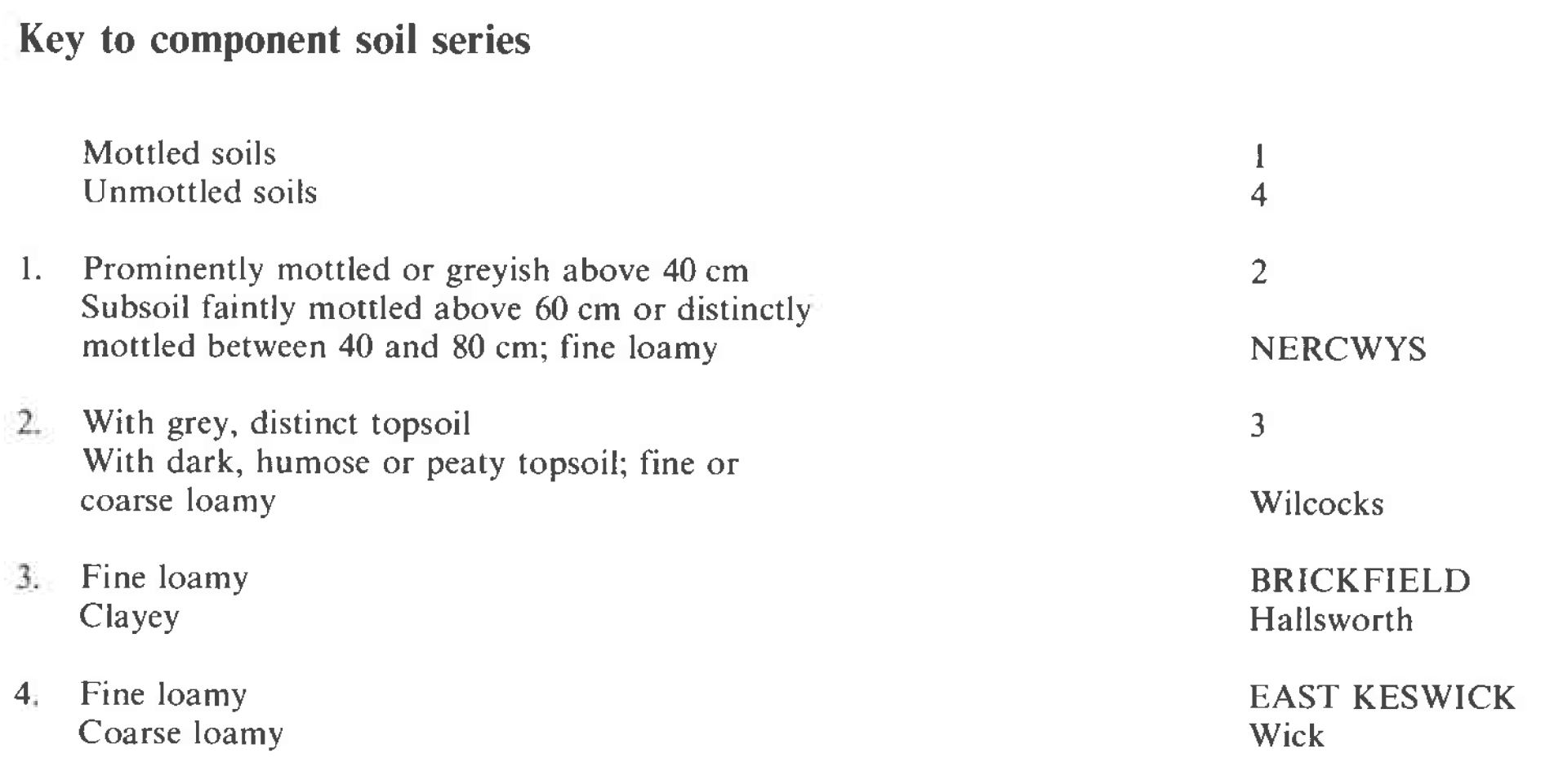
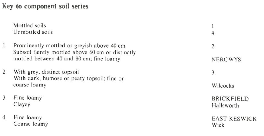
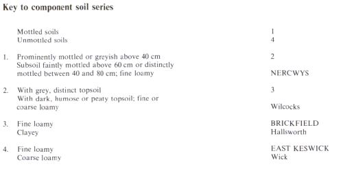
Component soil series
| Subgroup | Series name | Percentage | WRB 2006 link |
|---|---|---|---|
| 7.13 | BRICKFIELD | 40% | Eutric Stagnosols |
| 5.42 | NERCWYS | 20% | Eutric Stagnic Cambisols |
| 5.41 | EAST KESWICK | 15% | Eutric Cambisols |
Covers 1596 km2 in England and Wales
Soilscapes Classification
| 17 |
Slowly permeable seasonally wet acid loamy and clayey soils |
0713f BRICKFIELD 2
Detailed Description
This association consists of tine loamy soils in till or Head mainly derived from Carboniferous shale and sandstone. It extends from Lancashire to the Scottish border and is also found in Wales, Shropshire and Derbyshire, covering a range of country from gently undulating till plains to drumlins interspersed with peaty or alluvial hollows. Elevations are generally 60 to 260 m O.D. The predominant soils are cambic stagnogley soils, Brickfield series, with stagnogleyic and typical brown earths, Nercwys and East Keswick series respectively. The soils occur in drumlin country between Lancaster and Kirkby Lonsdale, in the valleys of the rivers Wenning, Hodder and Ribble, and in the Cliviger valley, south-east of Burnley. Although the drumlins have short and moderately steep sides (10 to 20 degrees), they are mainly covered by the Brickfield series, which is a surface-water gley soil because of the moderately high rainfall (over 1000 mm annually) and the predominance of fine textured slowly permeable subsoils. Better drained soils are restricted to the steepest upper slopes of the drumlins, where there is rapid run-off on to the alluvial gley or peat soils between them. Most drumlins overlie Millstone Grit, which outcrops sporadically. Near, Carnforth, however, they overlie both Carboniferous Limestone and Permo-Triassic rocks, although neither have any discernible effect on profile development. The association is also found in the Amber valley, Derbyshire and to the north of Oswestry. The association is mapped on drift from Carboniferous rocks in both the south Wales and the north Wales coalfields, where the Brickfield series was formerly identified as the Talog series. It generally occurs at a lower elevation and in a more dissected landscape than the soils of the related Wilcocks 1 association. The drier Nercwys and East Keswick soils are found on the steeper slopes and convex hill tops, while the Brickfield series is usually found on gentle slopes. Clayey Hallsworth soils occur locally.
Most soils on the drumlins at the northern fringes of the Lake District are gleyed, and brown earths occur only on the steepest slopes. Between the drumlins are alluvial gley soils or peat soils. In the Craven district of North Yorkshire however, some drumlins have cores of solid limestone and are covered by Nercwys series, while others are occupied by the clayey Hallsworth series. Soils in Craven often have calcareous subsurface horizons. In other areas, the Brickfield series is accompanied by similar soils with reddish colours (Clifton series) or with clay-enriched subsoil, namely, the Pinder series. In Northumberland it often contains igneous stones. With increasing elevation or in wet hollows, Wilcocks soils become more common. The Wick series is found over isolated patches of loamy drift.
Soil Water Regime
Although the Brickfield series has slowly permeable subsurface horizons and is seasonally waterlogged (Wetness Class IV), it usually responds to artificial drainage. The presence of stones can locally make mole drainage difficult. The East Keswick series is well drained (Wetness Class I), whereas the Nercwys series is usually in Wetness Class IV. Brickfield and Nercwys soils quickly become saturated and do not readily absorb winter rainwater, which drains away laterally, mainly within the top 50 cm. These soils are never droughty in normal years.In the relatively dry area of north-east Yorkshire these soils are slightly droughty under grass, but non-droughty under other crops.
Cropping and Land Use
The soils mainly occur where the field capacity period is greater than 225 days, so there are restricted opportunities for cultivation without damaging soils, even after field drainage. Much land is therefore in grassland. Dairying and hill sheep rearing are the traditional enterprises, but calves and store cattle are also reared. The grassland is often permanent, but kale, swedes and mangolds are occasionally grown and direct reseeding is also practised. The most productive land is below 75 m O.D., whereas much above 120 m O.D. is largely unimproved, with rough grazing for sheep. Rush-infestation is common. The land is not generally suited to intensive use, and winter stocking is not advisable because of the risk of poaching due to surface wetness. In the drier parts of Northumberland and North Yorkshire however, where there is less risk of poaching, intensive grazing and some winter use are possible. In the lower ground of Gisburn Forest, near Stocks Reservoir, there are Norway and Sitka spruce plantations. Deep ploughing and open drains are used to remove surplus water and encourage root penetration, so increasing resistance to the wind.
Annual rainfall on this association in Wales ranges from more than 1,600 mm in parts of the south to less than 800 mm in the north-east. In all areas however the soils are mainly under permanent grass or rush-infested rough grazing, and there is risk of severe poaching and liver fluke on undrained soils. Drainage measures, using permeable backfill followed by subsoiling or moling every four years, aid pasture improvement. Continuing care is needed, however, as a moderate poaching risk exists even after drainage. Flooding is another hazard on undrained Brickfield soils. Arable crops are largely restricted to forage, there being a better chance of success in the drier north even though the field capacity period is still more than 200 days. There are only a few days between September and May in most years when soil conditions are suitable for cultivation. Reserves of available moisture are usually adequate to ensure that the soils are non-droughty, although droughtiness can occur where topsoils have become compacted and rooting is restricted. Small areas of the association are used for forestry, Sitka spruce being the preferred species; site preparation involves deep ploughing and open drains to remove surplus water and encourage root penetration, so increasing resistance to the wind.
The association occurs in Thornthwaite Forest and in woodland near Dalton-in-Furness, Cumbria, where Norway spruce and western hemlock are the main species, with larch on sloping ground and ash and oak for amenity; in fact the land is suited to oak. The main limitation to tree growth is waterlogging, and drainage measures are essential to intercept lateral movement of water and promote deep rooting, which is essential if trees are not to be blown over. Potential yields are good in sheltered sites, but ground conditions are often difficult in winter. In some places there has been a marked response to phosphorus fertilizer.
0713f BRICKFIELD 2
Distribution Map
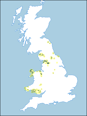 |
Note that the yellow shading represents a buffer to highlight the location of very small areas of the association.
Keys to component soil series
Midlands
 |
Northern Region
 |
Wales
 |
All information Copyright, Cranfield University © 2025
Citation: To use information from this web resource in your work, please cite this as follows:
Cranfield University 2025. The Soils Guide. Available: www.landis.org.uk. Cranfield University, UK. Last accessed 25/04/2025
