Soil Associations
0811a ENBORNE
Soil and site characteristics
Deep stoneless fine loamy and clayey soils variably affected by groundwater. Flat land. Risk of flooding.
Geology
River alluvium
Cropping and Land Use
Permanent grassland with stock rearing where flood risk low.
Component soil series
| Subgroup | Series name | Percentage | WRB 2006 link |
|---|---|---|---|
| 8.11 | ENBORNE | 60% | Fluvic Eutric Gleysols |
| 5.62 | TRENT | 20% | Eutric Fluvic Endogleyic Cambisols |
| 8.13 | FLADBURY | 15% | Clayic Fluvic Eutric Gleysols |
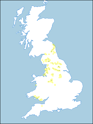
Covers 335 km2 in England and Wales
Soilscapes Classification
| 20 |
Loamy and clayey floodplain soils with naturally high groundwater |
0811a ENBORNE
Detailed Description
The Enborne association consists of stoneless, moderately permeable, fine loamy and clayey alluvial soils on floodplains affected by seasonal flooding and fluctuating groundwater levels, with more permeable soils on levees. It is found throughout Northern England, the Midlands and to a small extent in Wales and South East England, at altitudes ranging from 10 to 120 m O.D. The Enborne series, fine loamy typical alluvial gley soils in non-calcareous riverine alluvium, is widespread. The associated Trent series, fine loamy gleyic brown alluvial soils, is often found on levees. There are also clayey pelo-alluvial gley soils of the Fladbury series. The Enborne association is found mainly in Lancashire, particularly in the Lune, Wyre, Douglas, Lostock, Yarrow and Darwen valleys. The Enborne series is generally predominant but Fladbury soils, formerly mapped as a phase of the Douglas complex, are common on the alluvium in the Douglas valley. In the east Midlands, the main occurrence is along the valley of the river Ryton in north Nottinghamshire, where the Stixwould and Conway series are locally important and a small area of remnant peat, containing profiles of the Sulham series, exists. At Whitewater Common, north-east of Worksop and near Warsop, the association includes calcareous soils where streams from the Magnesian Limestone join those from the Sherwood Sandstone Group. In the western Midlands, the association occurs mainly in the Trent valley between Rugeley and Stoke-on-Trent where the Trent series is dominant. It is also found in the Endon Brook valley, north-east of Stoke, where silty Conway soils are included, and in the Sowe valley, north of Eccleshall, where clayey Fladbury and Compton soils are also present. In all these situations small, low terraces supporting Arrow, Quorndon and Wigton Moor soils, have been included in the association.
The association, which covers 136 km², consists mainly of soils of the Enborne series, with some Trent series. The Fladbury series is less common. The Alun series is a frequent associate alongside the rivers Eden and Lyne in Cumbria, and the Coquet in Northumberland. Along the middle reaches of the river Breamish, near Powburn, and along the river Aln to the west of Alnwick, Northumberland, fine loamy profiles merge upstream into gravelly profiles and downstream into soils of the Arrow series on river terrace drift. On levees at the river bank, soils of the Wharfe series are frequently more common than Trent profiles. Along the rivers Ouse, Aire and Rye, in Yorkshire, Wigton Moor soils occur on low terraces and alluvium overlies gravel locally, giving Kettlebottom soils. Peat underlies the alluvium near Scaleby, Cumbria.
In South East England, the association is only found in the Hamble valley in south Hampshire. The alluvium locally overlies gravel and in places there are seams of calcareous tufa or marl below the alluvium. Non-calcareous fine silty over gravelly humic and typical alluvial gley soils also occur. In the lower reaches of the valley, small areas of unripened clayey saltmarsh soils are found.
Soil Water Regime
Most Enborne soils are seasonally waterlogged (Wetness Class III and IV), but with underdrainage they are less wet (Wetness Class III). Trent soils are occasionally waterlogged (Wetness Class II) but the Fladbury series is waterlogged for long periods in winter (Wetness Class IV). There are large year-to-year differences in winter waterlogging, depending upon rainfall in the respective catchments. The soils become moderately droughty under grass in a normal year in the east Midlands.
Cropping and Land Use
Climate, soil wetness and, in places, the narrowness of the floodplain make the association unsuitable for sustained arable cropping. Nevertheless, arable crops are grown on wide tracts of alluvium in the Douglas valley and to the east of the Pennines, provided drainage measures have been installed and suitable outfalls are maintained. Cultivations need to be carefully timed however. There are sufficient good machinery work days for autumn cultivations and hence, winter cereals are the main crop. There are few such days in spring except in the driest areas. To the west of the Pennines, soils are suited to grassland and permanent pasture is dominant, where the moist climate sustains summer growth, though a moderate poaching risk limits use in winter and early spring.
0811a ENBORNE
Distribution Map
 |
Note that the yellow shading represents a buffer to highlight the location of very small areas of the association.
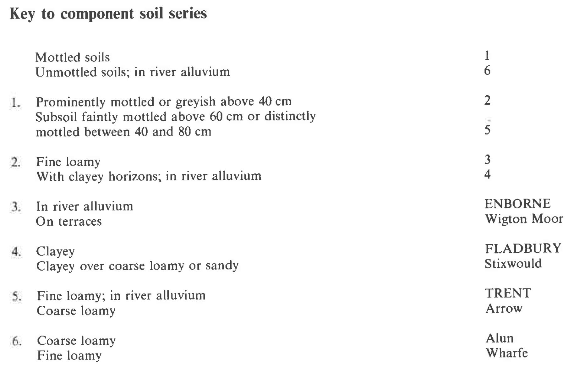
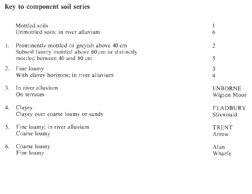
Keys to component soil series
Midlands
 |
Northern Region
 |
All information Copyright, Cranfield University © 2025
Citation: To use information from this web resource in your work, please cite this as follows:
Cranfield University 2025. The Soils Guide. Available: www.landis.org.uk. Cranfield University, UK. Last accessed 25/04/2025
