Soil Associations
0812c AGNEY
Soil and site characteristics
Deep stoneless calcareous fine and coarse silty soils. Groundwater usually controlled by ditches and pumps. Flat land.
Geology
Marine alluvium
Cropping and Land Use
Cereals, sugar beet, potatoes and field vegetables.
Component soil series
| Subgroup | Series name | Percentage | WRB 2006 link |
|---|---|---|---|
| 8.12 | AGNEY | 55% | Fluvic Calcaric Gleysols |
| 8.12 | WISBECH | 30% | Fluvic Calcaric Gleysols |
Covers 274 km2 in England and Wales
Soilscapes Classification
| 21 |
Loamy and clayey soils of coastal flats with naturally high groundwater |
0812c AGNEY
Detailed Description
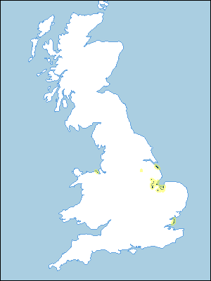
Agney Association consists mainly of calcareous alluvial gley soils belonging to Agney and Wisbech series developed in marine alluvium on flat reclaimed land at 2 to 8 m O.D. near the coast in parts of Humberside, Lincolnshire, Essex and Wales. The soils are stoneless and silty with brownish plough layers over greyish brown mottled horizons with blocky or relic laminar structure.
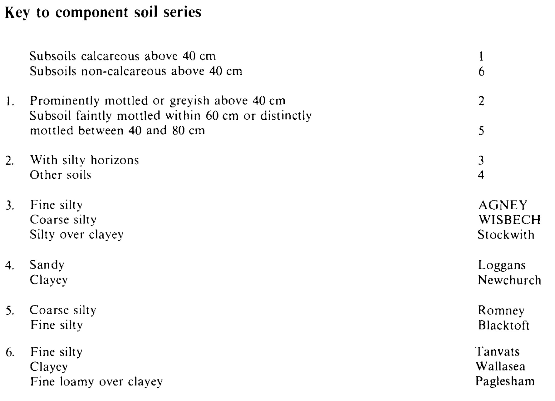
Typically, Agney association has about half Agney and one third Wisbech soils; Blacktoft, Newchurch, Romney, Stockwith, Tanvats and Wallasea, and some Pagleshamand Loggans series also occur. The degree of development of soil structure in Agney and Wisbech series depends upon the time since reclamation. On recently reclaimed land the original laminated sedimentary layers occur directly below the cultivated horizon, but on older sites, blocky soil structure has developed to 50 or 60 cm depth.
In Lincolnshire, where land has been reclaimed since 1970, around the Wash and in a small area near Boston, the association is composed consistently of Agney and Romney or Wisbech soils in a complex pattern. Many Agney soils have coarse silty layers below 50 cm depth. As elsewhere, the lighter Wisbech and Romney soils are on the sites of former creeks. In north-east Lincolnshire near Tetney and Marshchapel, there are low mounds up to 3 m above general marsh level formed by the medieval salt industry. The soils of these salterns are similar to Blacktoft series. Near Donna Nook, the alluvium overlies dune sand and near the coast Loggans series is included. Occasional Wallasea and Newchurch soils are also found.
In Essex the association is mainly on the Dengie peninsula and the seaward side of Foulness and Havengore Islands. On parts of the Dengie peninsula Romney and Newchurch series are common, and near the southern end of the peninsula the association is bounded to the west by shell ridges. On Foulness and Havengore islands there are a few Newchurch soils, and soils with clayey over fine silty layers are common.
The association covers a very small area in Humberside south of Cleethorpes. Generally, Wisbech and Romney soils are on the sites of former creeks, with Agney soils in the intervening areas. There are often low mounds up to 3 m above general marsh level formed by the medieval salt industry, the soils of these salterns being similar to Blacktoft series.
Soil Water Regime
The soils are very porous with numerous root channels and burrows formed under saltmarsh before reclamation. The land is mostly drained by ditches and pumps and the soils are rarely waterlogged (Wetness Class I). Parts of the Dengie peninsula suffer occasional flooding through breaches of the sea defences. The available water reserves of the Agney series are large and the soil is non-droughty for cereals and sugar beet. Shallow-rooting crops such as potatoes may suffer drought. In the dry climate of Essex crops on Agney soils suffer slightly more from droughtiness than in Lincolnshire. There are only minor limitations on grassland growth and utilization in Lincolnshire, but in Essex, droughtiness checks summer growth. Wisbech soils are well suited to grassland as well as other crops, because of their large moisture reserves.
Cropping and Land Use
The soils are easy to cultivate, though the heavier Agney soils are less so than Wisbech soils. The laminated subsoils of recently reclaimed soils compact readily below the plough layer. There are ample days available for cultivation in autumn and spring. The soils are not well suited to direct drilling because of their high silt content and the risk of compaction.
In Lincolnshire cereals, sugar beet and potatoes are grown and the land is used extensively for field vegetables, particularly brassicas. The Agney soils are not ideal for onion crops because sticky topsoils make it difficult to get a clean crop. In Essex arable crops, including cereals, potatoes and some sugar beet are grown. Lucerne and grass are grown locally. Many parts of Foulness Island have rough grazing around military installations.
0812c AGNEY
Distribution Map
 |
Note that the yellow shading represents a buffer to highlight the location of very small areas of the association.
Keys to component soil series
Eastern Region
 |
All information Copyright, Cranfield University © 2025
Citation: To use information from this web resource in your work, please cite this as follows:
Cranfield University 2025. The Soils Guide. Available: www.landis.org.uk. Cranfield University, UK. Last accessed 25/04/2025
